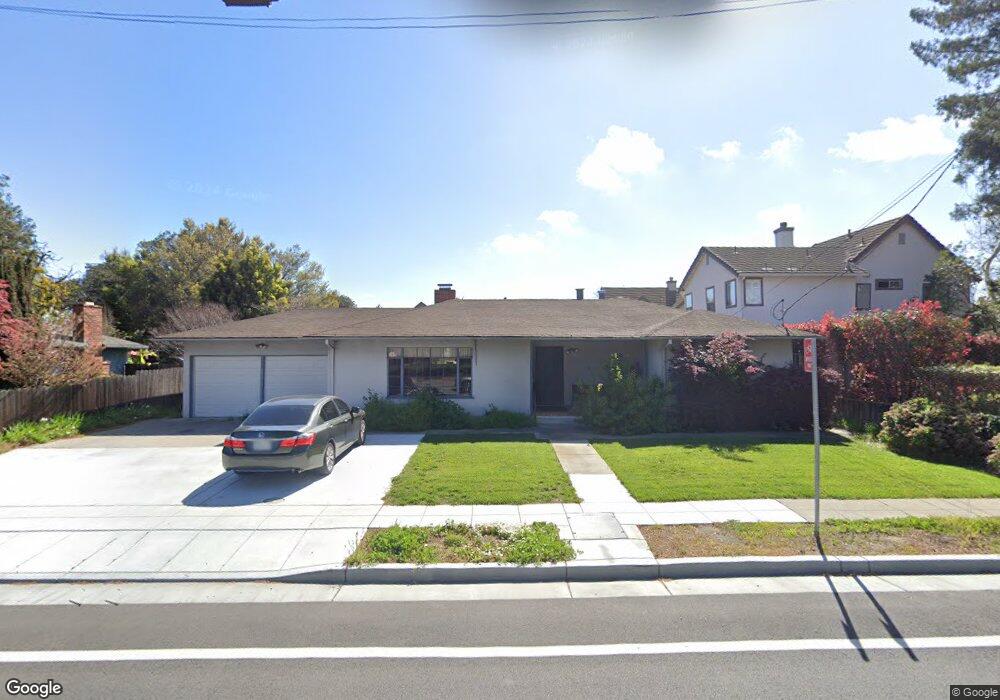
173 N Whisman Rd Mountain View, CA 94043
Whisman NeighborhoodEstimated Value: $1,942,000 - $2,586,000
2
Beds
1
Bath
1,346
Sq Ft
$1,751/Sq Ft
Est. Value
About This Home
This home is located at 173 N Whisman Rd, Mountain View, CA 94043 and is currently estimated at $2,356,216, approximately $1,750 per square foot. 173 N Whisman Rd is a home located in Santa Clara County with nearby schools including Edith Landels Elementary School, Crittenden Middle School, and Mountain View High School.
Ownership History
Date
Name
Owned For
Owner Type
Purchase Details
Closed on
May 26, 2021
Sold by
Johnson Peter E
Bought by
Johnson Peter E and Johnson Trust
Current Estimated Value
Purchase Details
Closed on
Apr 16, 2021
Sold by
Johnson Peter E and Johnson Peter E
Bought by
Johnson Peter E and Johnson Trust
Purchase Details
Closed on
Mar 22, 2021
Sold by
Johnson Peter E and Johnson Family Trust
Bought by
Johnson Peter E
Create a Home Valuation Report for This Property
The Home Valuation Report is an in-depth analysis detailing your home's value as well as a comparison with similar homes in the area
Home Values in the Area
Average Home Value in this Area
Purchase History
We collect this data history from publicly available records. To have your information removed, we recommend requesting removal directly through your county’s website.
| Date | Buyer | Sale Price | Title Company |
|---|---|---|---|
| Johnson Peter E | -- | None Available | |
| Johnson Peter E | -- | None Available | |
| Johnson Peter E | -- | None Available | |
| Johnson Peter E | -- | None Available |
Source: Public Records
Tax History
| Year | Tax Paid | Tax Assessment Tax Assessment Total Assessment is a certain percentage of the fair market value that is determined by local assessors to be the total taxable value of land and additions on the property. | Land | Improvement |
|---|---|---|---|---|
| 2025 | $1,001 | $76,635 | $40,166 | $36,469 |
| 2024 | $1,001 | $75,133 | $39,379 | $35,754 |
| 2023 | $990 | $73,660 | $38,607 | $35,053 |
| 2022 | $984 | $72,216 | $37,850 | $34,366 |
| 2021 | $807 | $70,801 | $37,108 | $33,693 |
| 2020 | $808 | $70,076 | $36,728 | $33,348 |
| 2019 | $773 | $68,703 | $36,008 | $32,695 |
| 2018 | $777 | $67,356 | $35,302 | $32,054 |
| 2017 | $746 | $66,036 | $34,610 | $31,426 |
| 2016 | $716 | $64,742 | $33,932 | $30,810 |
| 2015 | $696 | $63,771 | $33,423 | $30,348 |
| 2014 | $691 | $62,523 | $32,769 | $29,754 |
Source: Public Records
Map
Nearby Homes
- 361 Pacific Dr
- 3702 Pyramid Way
- 3806 Pyramid Way
- 154 Paseo Ct
- 217 Ada Ave Unit 16
- 189 Bedford Loop Unit 82
- 141 Huntington Ct
- 229 Orbit Way
- 365 Shelby Dr
- 118 Minaret Ave
- 209 Infinity Way
- 201 Flynn Ave Unit 16
- 201 Flynn Ave Unit 13
- 334 Circuit Way
- 317 Tyrella Ave
- 100 E Middlefield Rd Unit 3B
- 99 Sherland Ave Unit D
- 451 Chagall St
- 492 Kahlo St
- 325 Sylvan Ave Unit 23
- 185 Emerson Ln
- 187 Emerson Ln
- 183 Emerson Ln
- 184 Espinosa Ln
- 182 Espinosa Ln
- 186 Espinosa Ln
- 184 Emerson Ln
- 186 Emerson Ln
- 182 Emerson Ln
- 181 Emerson Ln
- 180 Espinosa Ln
- 180 Emerson Ln
- 185 Espinosa Ln
- 187 Espinosa Ln
- 183 Espinosa Ln
- 181 Espinosa Ln
- 308 Pacific Dr
- 184 Jenkins Ln
- 182 Jenkins Ln
- 186 Jenkins Ln
Your Personal Tour Guide
Ask me questions while you tour the home.