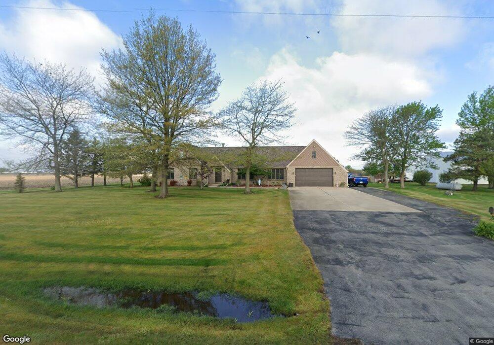
17311 Brisbin Rd Minooka, IL 60447
North Minooka NeighborhoodEstimated Value: $449,000 - $546,000
3
Beds
4
Baths
2,254
Sq Ft
$214/Sq Ft
Est. Value
About This Home
This home is located at 17311 Brisbin Rd, Minooka, IL 60447 and is currently estimated at $481,871, approximately $213 per square foot. 17311 Brisbin Rd is a home located in Kendall County with nearby schools including Jones Elementary School, Minooka Junior High School, and Minooka Intermediate School.
Ownership History
Date
Name
Owned For
Owner Type
Purchase Details
Closed on
Jun 6, 2018
Sold by
Shepherd Daniel T and Shepherd Bernadine M
Bought by
Shepherd Daniel T and Shepherd Bernadine M
Current Estimated Value
Purchase Details
Closed on
Apr 7, 2006
Sold by
Ward Thomas R and Ward Kimberly L
Bought by
Shepherd Daniel and Shepherd Bernadine
Purchase Details
Closed on
Jul 7, 1999
Sold by
Ward Thomas R
Bought by
Ward Thomas R and Ward Kimberly L
Home Financials for this Owner
Home Financials are based on the most recent Mortgage that was taken out on this home.
Original Mortgage
$80,000
Interest Rate
7.4%
Create a Home Valuation Report for This Property
The Home Valuation Report is an in-depth analysis detailing your home's value as well as a comparison with similar homes in the area
Home Values in the Area
Average Home Value in this Area
Purchase History
| Date | Buyer | Sale Price | Title Company |
|---|---|---|---|
| Shepherd Daniel T | -- | Attorney | |
| Shepherd Daniel | $340,000 | None Available | |
| Ward Thomas R | -- | Stewart Title Company |
Source: Public Records
Mortgage History
| Date | Status | Borrower | Loan Amount |
|---|---|---|---|
| Previous Owner | Ward Thomas R | $80,000 |
Source: Public Records
Tax History Compared to Growth
Tax History
| Year | Tax Paid | Tax Assessment Tax Assessment Total Assessment is a certain percentage of the fair market value that is determined by local assessors to be the total taxable value of land and additions on the property. | Land | Improvement |
|---|---|---|---|---|
| 2024 | $7,500 | $117,061 | $14,281 | $102,780 |
| 2023 | $6,136 | $106,207 | $13,427 | $92,780 |
| 2022 | $6,136 | $94,827 | $11,639 | $83,188 |
| 2021 | $5,871 | $90,015 | $11,816 | $78,199 |
| 2020 | $5,603 | $84,673 | $11,114 | $73,559 |
| 2019 | $5,461 | $81,011 | $10,633 | $70,378 |
| 2018 | $5,143 | $77,424 | $10,633 | $66,791 |
| 2017 | $5,035 | $73,348 | $10,633 | $62,715 |
| 2016 | $4,649 | $67,929 | $10,502 | $57,427 |
| 2015 | $4,641 | $67,929 | $10,502 | $57,427 |
| 2014 | -- | $62,164 | $10,502 | $51,662 |
| 2013 | -- | $62,164 | $10,502 | $51,662 |
Source: Public Records
Map
Nearby Homes
- 15781 Brisbin Rd
- 15771 Brisbin Rd
- 2823 Ninovan Ln
- 2811 Ninovan Ln
- 2817 Ninovan Ln
- 2812 Ninovan Ln
- 2813 Ninovan Ln
- 215 Slalom Ct
- 24 Aspen St
- 28 Doral St
- 1133 Coneflower Ct
- 2050 Isabella Ln
- 194 acres W Holt Rd
- 2041 Isabella Ln
- Lot 1 Minooka Ridge & Jones Rd
- 6010-6060 E Minooka Rd
- 2037 Isabella Ln
- 1510 Balboa Dr
- 921 Casey Dr
- 717 Casey Dr
- 17280 Brisbin Rd
- 17160 Brisbin Rd
- 10289 Caton Farm Rd
- 6232 White Willow Rd
- 5681 White Willow Rd
- 6319 White Willow Rd
- 5360 White Willow Rd
- 16700 Brisbin Rd
- 6718 White Willow Rd
- 0000 N Sherrill Rd
- 000 Sherrill Rd
- 3205 E Sherrill Rd
- 6387 E Sherrill Rd
- 16490 Brisbin Rd
- 2665 E Sherrill Rd
- 17765 Grove Rd
- 3545 E Sherrill Rd
- 4930 White Willow Rd
- 3775 E Sherrill Rd
- 17548 Church Rd