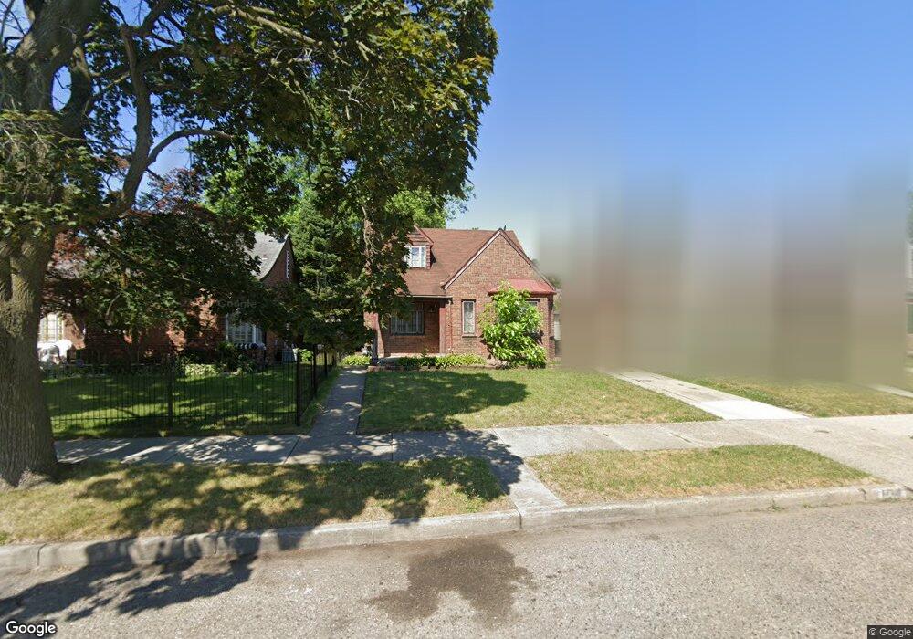
17311 Rutherford St Detroit, MI 48235
College Park NeighborhoodEstimated Value: $93,000 - $116,000
--
Bed
1
Bath
1,028
Sq Ft
$103/Sq Ft
Est. Value
About This Home
This home is located at 17311 Rutherford St, Detroit, MI 48235 and is currently estimated at $106,290, approximately $103 per square foot. 17311 Rutherford St is a home located in Wayne County with nearby schools including John R. King Academic And Performing Arts Academy, Charles L. Spain Elementary-Middle School, and Edward 'Duke' Ellington Conservatory of Music and Art.
Ownership History
Date
Name
Owned For
Owner Type
Purchase Details
Closed on
May 8, 2014
Sold by
Thornton Jannie
Bought by
Thornton Dorio
Current Estimated Value
Purchase Details
Closed on
Nov 7, 2013
Sold by
Wayne County Treasurer
Bought by
Thornton Jannie M
Purchase Details
Closed on
Mar 13, 2013
Sold by
Martin Butler and Martin Mary J
Bought by
Martin Butler and Butler Martin Trust
Create a Home Valuation Report for This Property
The Home Valuation Report is an in-depth analysis detailing your home's value as well as a comparison with similar homes in the area
Home Values in the Area
Average Home Value in this Area
Purchase History
| Date | Buyer | Sale Price | Title Company |
|---|---|---|---|
| Thornton Dorio | -- | None Available | |
| Thornton Jannie M | $8,900 | None Available | |
| Martin Butler | -- | None Available |
Source: Public Records
Tax History Compared to Growth
Tax History
| Year | Tax Paid | Tax Assessment Tax Assessment Total Assessment is a certain percentage of the fair market value that is determined by local assessors to be the total taxable value of land and additions on the property. | Land | Improvement |
|---|---|---|---|---|
| 2025 | $1,278 | $44,000 | $0 | $0 |
| 2024 | $1,278 | $38,500 | $0 | $0 |
| 2023 | $1,241 | $30,800 | $0 | $0 |
| 2022 | $1,322 | $24,300 | $0 | $0 |
| 2021 | $1,287 | $19,400 | $0 | $0 |
| 2020 | $1,286 | $16,800 | $0 | $0 |
| 2019 | $1,267 | $13,300 | $0 | $0 |
| 2018 | $1,113 | $12,000 | $0 | $0 |
| 2017 | $211 | $11,100 | $0 | $0 |
| 2016 | $1,379 | $15,100 | $0 | $0 |
| 2015 | $1,510 | $15,100 | $0 | $0 |
| 2013 | $2,213 | $22,133 | $0 | $0 |
| 2010 | -- | $32,450 | $937 | $31,513 |
Source: Public Records
Map
Nearby Homes
- 17360 Mansfield St
- 17211 Rutherford St
- 7275 W Outer Dr
- 7266 W Outer Dr
- 17130 Mansfield St
- 17196 Murray Hill St
- 17182 Murray Hill St
- 17151 Murray Hill St
- 16873 Mansfield St
- 16845 Prevost St
- 15626 Thatcher St
- 17552 Ferguson St
- 18071 Saint Marys St
- 16771 Forrer St
- 18021 Ferguson St
- 15900 Curtis St
- 18210 Saint Marys St
- 16727 Mansfield St
- 18230 Saint Marys St
- 16866 Greenfield Rd
- 17321 Rutherford St
- 17303 Rutherford St
- 17329 Rutherford St
- 17339 Rutherford St
- 17310 Mansfield St
- 17320 Mansfield St
- 17300 Mansfield St
- 17326 Mansfield St
- 17343 Rutherford St
- 17310 Rutherford St
- 17334 Mansfield St
- 17320 Rutherford St
- 17300 Rutherford St
- 17203 Rutherford St
- 17210 Mansfield St
- 17330 Rutherford St
- 17351 Rutherford St
- 17344 Mansfield St
- 17338 Rutherford St
- 17200 Mansfield St