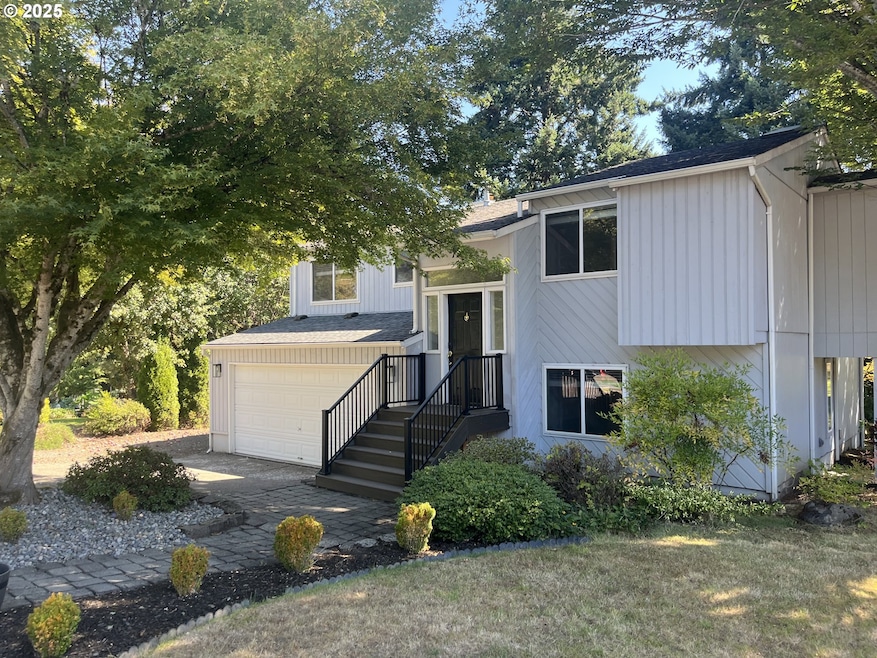
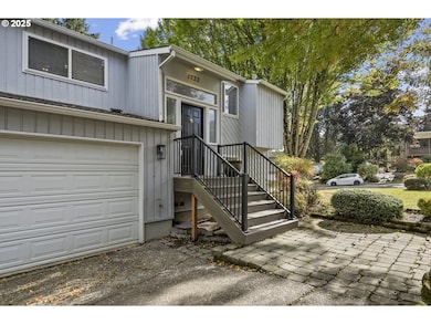
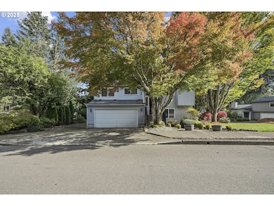

1733 Jamie Cir West Linn, OR 97068
Willamette NeighborhoodEstimated payment $3,681/month
Highlights
- Deck
- Wood Flooring
- Granite Countertops
- Willamette Primary School Rated A-
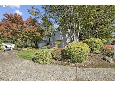
- Corner Lot
- No HOA
About This Home
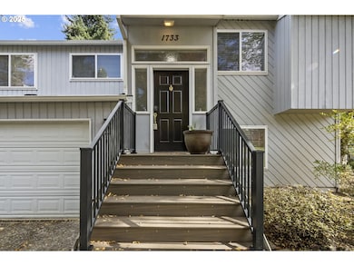
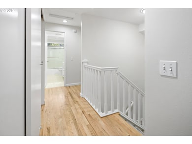
Open Sun 1-3 11/9. Here it is great location with fabulous schools! Nearby food carts, restaurants and shops. So much happening in West Linn, music, boating, farmers markets. This is a fun place to call home! New flooring, paint, light fixtures, furnace, carpeting and decking. 4 bedrooms! Many updates with spacious, corner lot and mature landscaping.
Listing Agent
Premiere Property Group, LLC License #790900504 Listed on: 10/18/2025

Open House Schedule
-
Sunday, December 14, 20251:00 to 3:00 pm12/14/2025 1:00:00 PM +00:0012/14/2025 3:00:00 PM +00:00Stop by and enjoy this two-level West Linn home! New carpet, paint, deck, and furnace. Spacious lot and fabulous schools. Seller awaits your offer!!!Add to Calendar
Home Details
Home Type
- Single Family
Est. Annual Taxes
- $5,161
Year Built
- Built in 1977
Parking
- 2 Car Attached Garage
- Garage Door Opener
Home Design
- Split Level Home
- Wood Siding
Interior Spaces
- 1,646 Sq Ft Home
- 2-Story Property
- Gas Fireplace
- Family Room
- Living Room
- Dining Room
- Wood Flooring
Kitchen
- Dishwasher
- Granite Countertops
- Disposal
Bedrooms and Bathrooms
- 4 Bedrooms
Schools
- Willamette Elementary School
- Athey Creek Middle School
- West Linn High School
Utilities
- Forced Air Heating and Cooling System
- Heating System Uses Gas
Additional Features
- Deck
- Corner Lot
Community Details
- No Home Owners Association
- Willamette Subdivision
Listing and Financial Details
- Assessor Parcel Number 00408829
Map
Home Values in the Area
Average Home Value in this Area
Tax History
| Year | Tax Paid | Tax Assessment Tax Assessment Total Assessment is a certain percentage of the fair market value that is determined by local assessors to be the total taxable value of land and additions on the property. | Land | Improvement |
|---|---|---|---|---|
| 2025 | $5,161 | $267,822 | -- | -- |
| 2024 | $4,968 | $260,022 | -- | -- |
| 2023 | $4,968 | $252,449 | $0 | $0 |
| 2022 | $4,689 | $245,097 | $0 | $0 |
| 2021 | $4,451 | $237,959 | $0 | $0 |
| 2020 | $4,482 | $231,029 | $0 | $0 |
| 2019 | $4,274 | $224,300 | $0 | $0 |
| 2018 | $4,083 | $217,767 | $0 | $0 |
| 2017 | $3,925 | $211,424 | $0 | $0 |
| 2016 | $3,823 | $205,266 | $0 | $0 |
| 2015 | $3,627 | $199,287 | $0 | $0 |
| 2014 | $3,464 | $193,483 | $0 | $0 |
Property History
| Date | Event | Price | List to Sale | Price per Sq Ft |
|---|---|---|---|---|
| 11/07/2025 11/07/25 | Price Changed | $619,900 | -1.4% | $377 / Sq Ft |
| 10/18/2025 10/18/25 | For Sale | $629,000 | -- | $382 / Sq Ft |
Purchase History
| Date | Type | Sale Price | Title Company |
|---|---|---|---|
| Warranty Deed | $382,500 | Wfg Title | |
| Interfamily Deed Transfer | -- | None Available | |
| Interfamily Deed Transfer | -- | -- | |
| Warranty Deed | $128,000 | Transamerica Title Insurance |
Mortgage History
| Date | Status | Loan Amount | Loan Type |
|---|---|---|---|
| Previous Owner | $94,000 | No Value Available |
Source: Regional Multiple Listing Service (RMLS)
MLS Number: 767903453
APN: 00408829
Disclaimer: Certain information contained herein is derived from information provided by parties other than Homes.com. All information provided is deemed reliable, but is not guaranteed to be accurate and should be independently verified.
![]() The content relating to real estate for sale on this web site comes in part from the IDX program of the RMLS™ of Portland, Oregon. Real estate listings held by brokerage firms other than Ten-X are marked with the RMLS™ logo, and detailed information about these properties includes the names of the listing brokers. Listing content is copyright © 2025 RMLS™, Portland, Oregon. Some properties which appear for sale on this web site may subsequently have sold or may no longer be available. All information provided is deemed reliable but is not guaranteed and should be independently verified.
The content relating to real estate for sale on this web site comes in part from the IDX program of the RMLS™ of Portland, Oregon. Real estate listings held by brokerage firms other than Ten-X are marked with the RMLS™ logo, and detailed information about these properties includes the names of the listing brokers. Listing content is copyright © 2025 RMLS™, Portland, Oregon. Some properties which appear for sale on this web site may subsequently have sold or may no longer be available. All information provided is deemed reliable but is not guaranteed and should be independently verified.
- 1925 Hillhouse Dr
- 1931 13th St
- 1721 Dollar St Unit 1721
- 2026 Virginia Ln
- 1791 Blankenship Rd
- 1694 16th St
- 1690 16th St
- 975 Springtree Ln
- 850 Springtree Ln Unit 850
- 880 Springtree Ln Unit 880
- 800 Springtree Ln
- 640 Springtree Ln
- 4650 Summerlinn Way
- 3850 Summerlinn Dr Unit 58
- 25540 Cheryl Dr
- 3565 Summerlinn Dr Unit 64
- 2077 5th Ave
- 1160 Blankenship Rd
- 3395 Summerlinn Dr Unit 24
- 1315 11th St
- 400 Springtree Ln
- 22100 Horizon Dr
- 129 Deerbrook Dr
- 421 5th Ave Unit Primary Home
- 18713 Central Point Rd
- 4001 Robin Place
- 535 Holmes Ln
- 819 10th St
- 775 Cascade St
- 1937 Main St
- 19739 River Rd
- 19725 River Rd
- 19202 SE River Rd
- 470-470 W Gloucester St Unit 430
- 470-470 W Gloucester St Unit 440
- 847 Risley Ave
- 18348 SE River Rd
- 1840 Molalla Ave
- 275 Ipswich St Unit 261A
- 1691 Parrish St Unit Your home away from home