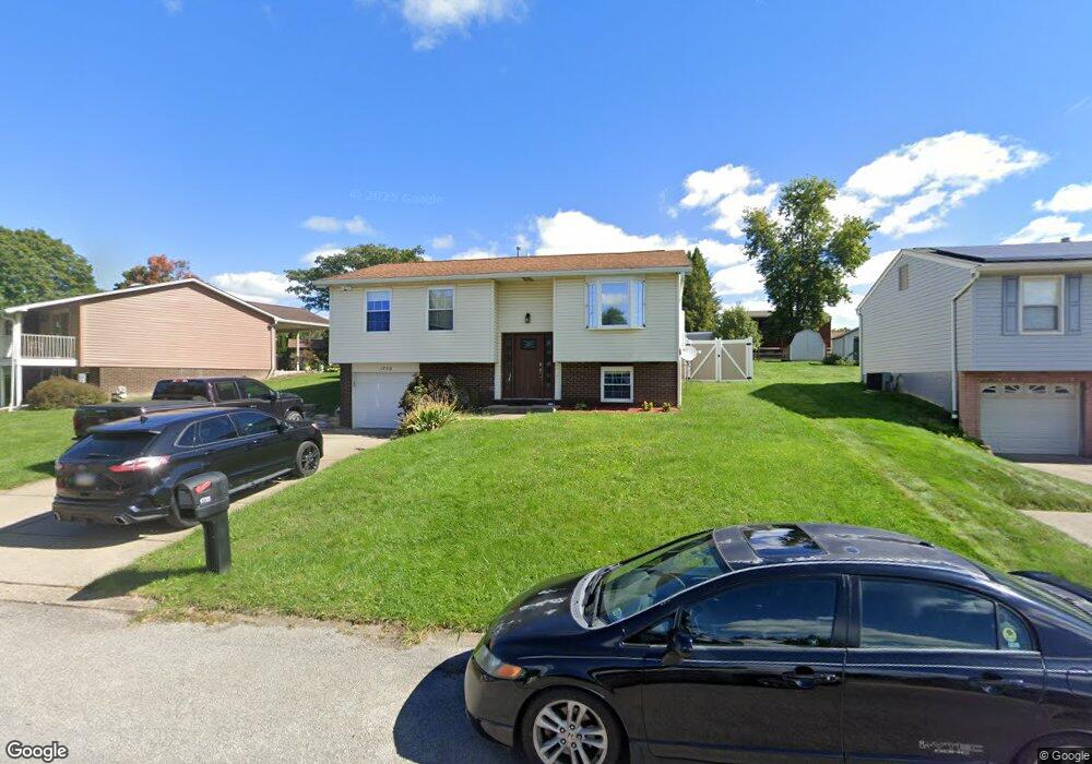
1733 Porter St Conway, PA 15027
Estimated Value: $232,000 - $270,000
3
Beds
1
Bath
1,836
Sq Ft
$136/Sq Ft
Est. Value
About This Home
This home is located at 1733 Porter St, Conway, PA 15027 and is currently estimated at $249,816, approximately $136 per square foot. 1733 Porter St is a home located in Beaver County with nearby schools including Freedom Area Elementary School, Freedom Area Middle School, and Freedom Area Senior High School.
Ownership History
Date
Name
Owned For
Owner Type
Purchase Details
Closed on
Feb 17, 2006
Sold by
Benson Larry K
Bought by
Galderisi Brandon
Current Estimated Value
Home Financials for this Owner
Home Financials are based on the most recent Mortgage that was taken out on this home.
Original Mortgage
$96,550
Interest Rate
6.62%
Mortgage Type
New Conventional
Purchase Details
Closed on
Mar 29, 2001
Sold by
Est Iris G Sheetz
Bought by
Benson Larry K
Create a Home Valuation Report for This Property
The Home Valuation Report is an in-depth analysis detailing your home's value as well as a comparison with similar homes in the area
Home Values in the Area
Average Home Value in this Area
Purchase History
| Date | Buyer | Sale Price | Title Company |
|---|---|---|---|
| Galderisi Brandon | $120,695 | -- | |
| Benson Larry K | $25,000 | -- |
Source: Public Records
Mortgage History
| Date | Status | Borrower | Loan Amount |
|---|---|---|---|
| Previous Owner | Galderisi Brandon | $96,550 |
Source: Public Records
Tax History
| Year | Tax Paid | Tax Assessment Tax Assessment Total Assessment is a certain percentage of the fair market value that is determined by local assessors to be the total taxable value of land and additions on the property. | Land | Improvement |
|---|---|---|---|---|
| 2025 | $701 | $95,500 | $17,100 | $78,400 |
| 2024 | $3,272 | $95,500 | $17,100 | $78,400 |
| 2023 | $3,460 | $28,150 | $3,550 | $24,600 |
| 2022 | $3,361 | $28,150 | $3,550 | $24,600 |
| 2021 | $3,361 | $28,150 | $3,550 | $24,600 |
| 2020 | $3,133 | $28,150 | $3,550 | $24,600 |
| 2019 | $3,133 | $28,150 | $3,550 | $24,600 |
| 2018 | $3,012 | $28,150 | $3,550 | $24,600 |
| 2017 | $3,012 | $28,150 | $3,550 | $24,600 |
| 2016 | $2,747 | $28,150 | $3,550 | $24,600 |
| 2015 | $625 | $28,150 | $3,550 | $24,600 |
| 2014 | $625 | $28,150 | $3,550 | $24,600 |
Source: Public Records
Map
Nearby Homes
- 744 N Gross St
- 616 Snyder St
- 1508 Dupont St
- 1227 Porter St
- 245 Conway Wallrose Rd
- 1203 2nd Ave
- 500 Conway Wallrose Rd
- 1025 Catherine Dr
- 1001 2nd Ave
- 450 Knollwood Cir
- 1530 6th Ave
- 0 Romigh Rd Unit 1748054
- 155 Sproat Ave
- 0 Orchard Ave Unit 1725623
- 1369 5th Ave
- 1365 5th Ave
- 47B River Ridge Ct
- 54B River Ridge Ct
- 154 Shady River Blvd
- 144 Shady River Blvd
Your Personal Tour Guide
Ask me questions while you tour the home.