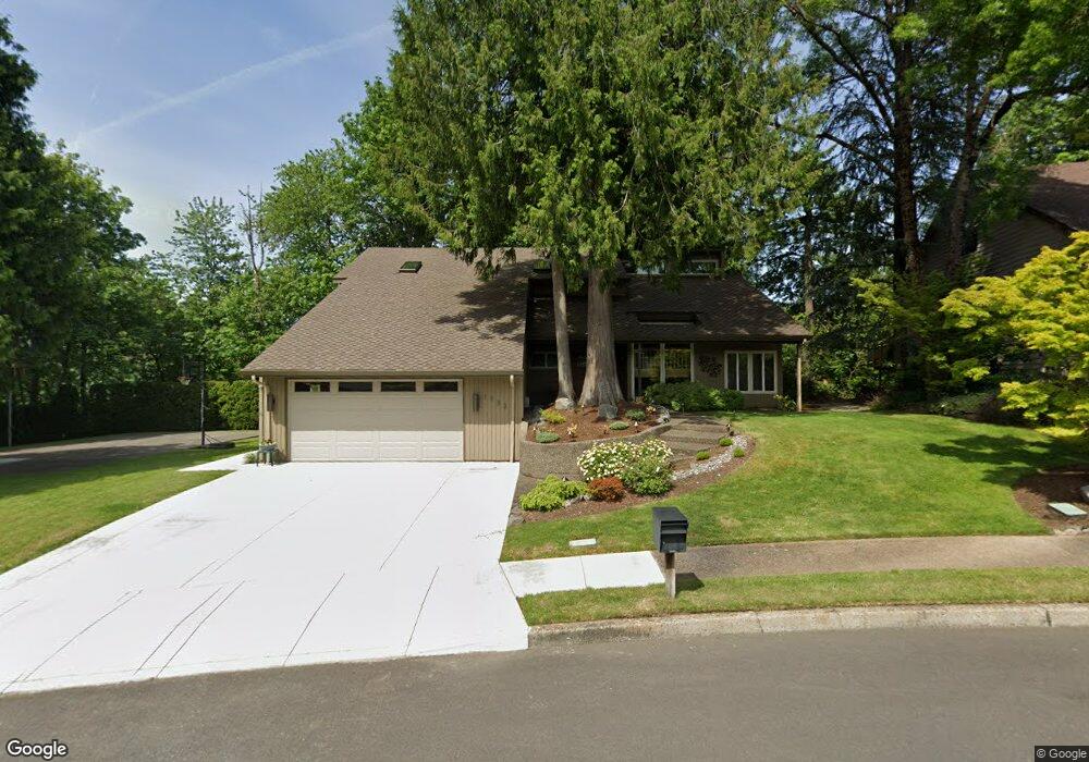
1733 SW 24th Dr Gresham, OR 97080
Southwest Gresham NeighborhoodEstimated Value: $605,000 - $784,000
3
Beds
4
Baths
2,762
Sq Ft
$250/Sq Ft
Est. Value
About This Home
This home is located at 1733 SW 24th Dr, Gresham, OR 97080 and is currently estimated at $690,208, approximately $249 per square foot. 1733 SW 24th Dr is a home located in Multnomah County with nearby schools including Dexter McCarty Middle School, Gresham High School, and Portland Adventist Elementary School.
Ownership History
Date
Name
Owned For
Owner Type
Purchase Details
Closed on
Jun 26, 2017
Sold by
Cumming Janet K
Bought by
Cumming Janet Kay and The Janet Kay Cumming Trust
Current Estimated Value
Purchase Details
Closed on
Dec 4, 2002
Sold by
Cumming Kent
Bought by
Cumming Kent L and Cumming Janet K
Home Financials for this Owner
Home Financials are based on the most recent Mortgage that was taken out on this home.
Original Mortgage
$97,300
Interest Rate
6.28%
Mortgage Type
Purchase Money Mortgage
Create a Home Valuation Report for This Property
The Home Valuation Report is an in-depth analysis detailing your home's value as well as a comparison with similar homes in the area
Home Values in the Area
Average Home Value in this Area
Purchase History
| Date | Buyer | Sale Price | Title Company |
|---|---|---|---|
| Cumming Janet Kay | -- | None Available | |
| Cumming Kent L | -- | Chicago Title |
Source: Public Records
Mortgage History
| Date | Status | Borrower | Loan Amount |
|---|---|---|---|
| Closed | Cumming Kent L | $97,300 |
Source: Public Records
Tax History
| Year | Tax Paid | Tax Assessment Tax Assessment Total Assessment is a certain percentage of the fair market value that is determined by local assessors to be the total taxable value of land and additions on the property. | Land | Improvement |
|---|---|---|---|---|
| 2025 | $9,278 | $455,930 | -- | -- |
| 2024 | $8,881 | $442,660 | -- | -- |
| 2023 | $8,092 | $429,770 | $0 | $0 |
| 2022 | $7,865 | $417,260 | $0 | $0 |
| 2021 | $7,667 | $405,110 | $0 | $0 |
| 2020 | $7,214 | $393,320 | $0 | $0 |
| 2019 | $7,025 | $381,870 | $0 | $0 |
| 2018 | $6,699 | $370,750 | $0 | $0 |
| 2017 | $6,427 | $359,960 | $0 | $0 |
| 2016 | $5,667 | $349,480 | $0 | $0 |
Source: Public Records
Map
Nearby Homes
- 1441 SW 23rd Ct
- 1421 SW Binford Lake Pkwy
- 2520 SW Towle Ave
- 1645 SW 27th St
- 2294 SW Wallula Ln
- 1333 SW 19th Dr
- 2160 SW 26th St
- 1278 SW 27th Ct
- 3120 SW Orchard Place
- 1320 SW 31st St
- 1960 SW 13th Ct
- 0 SW Battaglia Ave
- 1963 SW Myers Place
- 1175 SW Chastain Dr
- 2715 SW 31st St
- 3079 SW 22nd St
- 2398 SW Tegart Ave
- 3506 SW Battaglia Ave
- 3512 SW Battaglia Ave
- 3536 SW Battaglia Ave
- 1748 SW Binford Lake Pkwy
- 1686 SW Binford Lake Pkwy
- 1677 SW 24th Dr
- 1782 SW Binford Lake Pkwy
- 2413 SW Orchard Ave
- 1849 SW 24th Dr
- 1662 SW Binford Lake Pkwy
- 1842 SW 24th Dr
- 1659 SW 24th Dr
- 1832 SW Binford Lake Pkwy
- 1654 SW Binford Lake Pkwy
- 1832 SW Binford Lake Pw
- 2436 SW Orchard Ave
- 2425 SW Orchard Ave
- 1877 SW 24th Dr
- 1747 SW Binford Lake Pkwy
- 2257 SW Towle Ave
- 2299 SW Towle Ave
- 2232 SW Willowbrook Ave
- 1591 SW 24th Dr
Your Personal Tour Guide
Ask me questions while you tour the home.