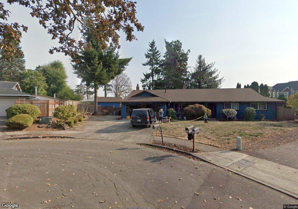
17340 Timothy Way Gladstone, OR 97027
Estimated Value: $507,878 - $570,000
3
Beds
2
Baths
1,568
Sq Ft
$341/Sq Ft
Est. Value
About This Home
This home is located at 17340 Timothy Way, Gladstone, OR 97027 and is currently estimated at $535,220, approximately $341 per square foot. 17340 Timothy Way is a home located in Clackamas County with nearby schools including John Wetten Elementary School, Walter L Kraxberger Middle School, and Gladstone High School.
Ownership History
Date
Name
Owned For
Owner Type
Purchase Details
Closed on
Aug 7, 2001
Sold by
Johnson Maurice and Nienstadt Carlene
Bought by
Brown David A and Brown Nancy G
Current Estimated Value
Home Financials for this Owner
Home Financials are based on the most recent Mortgage that was taken out on this home.
Original Mortgage
$132,400
Outstanding Balance
$50,875
Interest Rate
7.1%
Estimated Equity
$484,345
Create a Home Valuation Report for This Property
The Home Valuation Report is an in-depth analysis detailing your home's value as well as a comparison with similar homes in the area
Home Values in the Area
Average Home Value in this Area
Purchase History
| Date | Buyer | Sale Price | Title Company |
|---|---|---|---|
| Brown David A | $165,500 | First American |
Source: Public Records
Mortgage History
| Date | Status | Borrower | Loan Amount |
|---|---|---|---|
| Open | Brown David A | $132,400 |
Source: Public Records
Tax History
| Year | Tax Paid | Tax Assessment Tax Assessment Total Assessment is a certain percentage of the fair market value that is determined by local assessors to be the total taxable value of land and additions on the property. | Land | Improvement |
|---|---|---|---|---|
| 2025 | $5,862 | $290,952 | -- | -- |
| 2024 | $5,700 | $282,478 | -- | -- |
| 2023 | $5,700 | $274,251 | $0 | $0 |
| 2022 | $5,301 | $266,264 | $0 | $0 |
| 2021 | $5,106 | $258,509 | $0 | $0 |
| 2020 | $4,984 | $250,980 | $0 | $0 |
| 2019 | $4,926 | $243,670 | $0 | $0 |
| 2018 | $4,747 | $236,573 | $0 | $0 |
| 2017 | $4,605 | $229,683 | $0 | $0 |
| 2016 | $4,453 | $222,993 | $0 | $0 |
Source: Public Records
Map
Nearby Homes
- 7655 Ridgewood Dr
- 17788 Webster Rd
- 17928 Webster Rd
- 17110 Parkers Dr
- 16981 Stanhelma Dr
- 7175 Ridgegate Dr
- 17900 Monticello Dr
- 17520 SE 82nd Dr
- 16981 SE 80th Place
- 17915 Monticello Dr
- 8370 SE Poppy St
- 17125 SE 82nd Dr Unit 62
- 16510 SE 81st Ave
- 780 E Kenmore St
- 6830 Glen Echo Ave
- 16232 SE Lillian Ct
- 8630 SE Frontier Ct Unit 40
- 16260 SE 80th Ave
- 16261 SE 79th Ave
- 1065 Columbia Ave
- 17330 Timothy Way
- 17344 Timothy Way
- 17345 Timothy Way
- 17595 Kirkwood St
- 17350 Timothy Way
- 17621 Kirkwood St
- 17335 Timothy Way
- 17555 Kirkwood St
- 17320 Timothy Way
- 7580 Springhill Dr
- 17685 Kirkwood St
- 7590 Springhill Dr
- 8122 Cox Ln
- 7610 Charolais Ct
- 7585 Springhill Ct
- 7600 Springhill Dr
- 17310 Timothy Way
- 7595 Springhill Ct
- 17697 Kirkwood St
- 17547 Kirkwood St
Your Personal Tour Guide
Ask me questions while you tour the home.