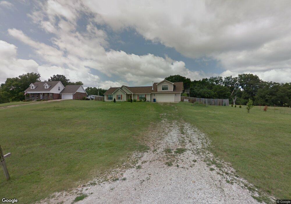
1737 Clark St Pea Ridge, AR 72751
Estimated Value: $394,000 - $471,000
3
Beds
2
Baths
2,320
Sq Ft
$184/Sq Ft
Est. Value
About This Home
This home is located at 1737 Clark St, Pea Ridge, AR 72751 and is currently estimated at $427,540, approximately $184 per square foot. 1737 Clark St is a home located in Benton County with nearby schools including Pea Ridge Intermediate School, Pea Ridge Primary School, and Pea Ridge Junior High School.
Ownership History
Date
Name
Owned For
Owner Type
Purchase Details
Closed on
Nov 1, 2010
Sold by
Federal National Mortgage Association
Bought by
Anderson Anthony S and Anderson Alisa F
Current Estimated Value
Home Financials for this Owner
Home Financials are based on the most recent Mortgage that was taken out on this home.
Original Mortgage
$121,153
Outstanding Balance
$79,826
Interest Rate
4.32%
Estimated Equity
$347,714
Purchase Details
Closed on
Aug 5, 2010
Sold by
Stanley Rick and Stanley Amy L
Bought by
Arvest Mortgage Company
Purchase Details
Closed on
Jul 29, 2010
Sold by
Arvest Mortgage Company
Bought by
Federal National Mortgage Association
Purchase Details
Closed on
Jul 12, 2004
Bought by
Stanley
Create a Home Valuation Report for This Property
The Home Valuation Report is an in-depth analysis detailing your home's value as well as a comparison with similar homes in the area
Home Values in the Area
Average Home Value in this Area
Purchase History
| Date | Buyer | Sale Price | Title Company |
|---|---|---|---|
| Anderson Anthony S | -- | None Available | |
| Arvest Mortgage Company | $110,000 | None Available | |
| Federal National Mortgage Association | -- | None Available | |
| Stanley | -- | -- |
Source: Public Records
Mortgage History
| Date | Status | Borrower | Loan Amount |
|---|---|---|---|
| Open | Anderson Anthony S | $121,153 |
Source: Public Records
Tax History Compared to Growth
Tax History
| Year | Tax Paid | Tax Assessment Tax Assessment Total Assessment is a certain percentage of the fair market value that is determined by local assessors to be the total taxable value of land and additions on the property. | Land | Improvement |
|---|---|---|---|---|
| 2025 | $2,736 | $74,704 | $11,300 | $63,404 |
| 2024 | $2,679 | $74,704 | $11,300 | $63,404 |
| 2023 | $2,552 | $54,770 | $4,290 | $50,480 |
| 2022 | $2,173 | $54,770 | $4,290 | $50,480 |
| 2021 | $2,035 | $54,770 | $4,290 | $50,480 |
| 2020 | $1,996 | $39,000 | $1,700 | $37,300 |
| 2019 | $1,907 | $39,000 | $1,700 | $37,300 |
| 2018 | $1,837 | $39,000 | $1,700 | $37,300 |
| 2017 | $1,959 | $39,000 | $1,700 | $37,300 |
| 2016 | $1,959 | $39,000 | $1,700 | $37,300 |
| 2015 | $1,780 | $31,290 | $3,330 | $27,960 |
| 2014 | $1,780 | $31,290 | $3,330 | $27,960 |
Source: Public Records
Map
Nearby Homes
- 195 W Pickens Rd
- 400 W Pickens Rd
- 264 Mcintosh St
- 446 W Pickens Rd
- 287 Mcintosh St
- 2288 Hayden Rd
- 1821 Woodhause Cir
- 2320 Barnes Cir
- 2018 Hayden Rd
- 117 Van Dorn St
- 1600 Christman St
- 1893 Hayden Rd
- 296 Van Dorn St
- 2350 Brooks Cir
- 1717 Cuppett Cir
- 1701 Cuppett Cir
- 1703 Cuppett Cir
- 1715 Cuppett Cir
- 1051 Asboth St
- 1305 Joyce St