


1738 University Ave W Saint Paul, MN 55104
Union Park NeighborhoodEstimated payment $5,943/month
Highlights
- Corner Lot
- No HOA
- 2-minute walk to Dickerman Park
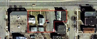
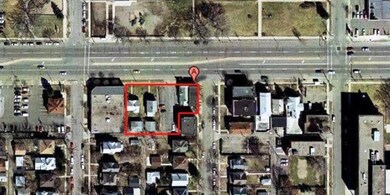
About This Lot
Unleash Your Vision in St. Paul’s Hottest Redevelopment Hub! Six prime parcels all conjoining (Pid#'s are
332923420006, 332923420008, 332923420009, 332923420010, 332923420011, 332923420012), spanning 0.46 acres,
perfectly perched along the vibrant Green Line Light Rail. Zoned T4+ for maximum development flexibility,
this is your canvas for innovation! Just a stone’s throw from Allianz Field, Fairview Ave and Penn Ave
Stations, the University of Minnesota Campus, and the bustling Midway district—all within a mile. Seize
this electrifying opportunity for transit-oriented brilliance!
Property currently consists of 2 mixed use commercial buildings, 1 duplex, 1 single family, and parking
lot. Monthly rent: $1800 (1744 University Single Family home), $2000 (1738 University Duplex, total for
both units), $1150 (471 Herschel lower unit commercial space), $950 (1728 University upper residential
unit), $1000 (1730 University upper residential unit ), (1 vacancy is lower commercial unit of 1730
University) = $6,900 per month.
Property Details
Property Type
- Land
Est. Annual Taxes
- $14,708
Lot Details
- Lot Dimensions are 184x70x44x51x140x121
- Corner Lot
Community Details
- No Home Owners Association
- Howard Park Subdivision
Listing and Financial Details
- Assessor Parcel Number 332923420011
Map
Home Values in the Area
Average Home Value in this Area
Tax History
| Year | Tax Paid | Tax Assessment Tax Assessment Total Assessment is a certain percentage of the fair market value that is determined by local assessors to be the total taxable value of land and additions on the property. | Land | Improvement |
|---|---|---|---|---|
| 2025 | $3,622 | $163,800 | $26,200 | $137,600 |
| 2023 | $3,622 | $156,000 | $26,200 | $129,800 |
| 2022 | $3,170 | $145,800 | $26,200 | $119,600 |
| 2021 | $3,402 | $137,500 | $26,200 | $111,300 |
| 2020 | $3,188 | $141,800 | $17,500 | $124,300 |
| 2019 | $2,816 | $127,500 | $17,500 | $110,000 |
| 2018 | $2,878 | $112,400 | $17,500 | $94,900 |
| 2017 | $2,608 | $120,200 | $17,500 | $102,700 |
| 2016 | $2,664 | $0 | $0 | $0 |
| 2015 | $2,690 | $103,600 | $45,400 | $58,200 |
| 2014 | $2,684 | $0 | $0 | $0 |
Property History
| Date | Event | Price | List to Sale | Price per Sq Ft |
|---|---|---|---|---|
| 09/30/2025 09/30/25 | For Sale | $895,000 | -- | -- |
Source: NorthstarMLS
MLS Number: 6797783
APN: 33-29-23-42-0011
Disclaimer: Certain information contained herein is derived from information provided by parties other than Homes.com. All information provided is deemed reliable, but is not guaranteed to be accurate and should be independently verified.
![]() Based on information submitted to the MLS GRID. All data is obtained from various sources and may not have been verified by broker or MLS GRID. Supplied Open House Information is subject to change without notice. All information should be independently reviewed and verified for accuracy. Properties may or may not be listed by the office/agent presenting the information. Some IDX listings have been excluded from this website.
Based on information submitted to the MLS GRID. All data is obtained from various sources and may not have been verified by broker or MLS GRID. Supplied Open House Information is subject to change without notice. All information should be independently reviewed and verified for accuracy. Properties may or may not be listed by the office/agent presenting the information. Some IDX listings have been excluded from this website.
The Digital Millennium Copyright Act of 1998, 17 U.S.C. § 512 (the “DMCA”) provides recourse for copyright owners who believe that material appearing on the Internet infringes their rights under U.S. copyright law. If you believe in good faith that any content or material made available in connection with our website or services infringes your copyright, you (or your agent) may send us a notice requesting that the content or material be removed, or access to it blocked.
Notices must be sent in writing by email to DMCAnotice@MLSGrid.com.
The DMCA requires that your notice of alleged copyright infringement include the following information:
(1) description of the copyrighted work that is the subject of claimed infringement;
(2) description of the alleged infringing content and information sufficient to permit us to locate the content;
(3) contact information for you, including your address, telephone number and email address;
(4) a statement by you that you have a good faith belief that the content in the manner complained of is not authorized by the copyright owner, or its agent, or by the operation of any law;
(5) a statement by you, signed under penalty of perjury, that the information in the notification is accurate and that you have the authority to enforce the copyrights that are claimed to be infringed; and
(6) a physical or electronic signature of the copyright owner or a person authorized to act on the copyright owner’s behalf. Failure to include all of the above information may result in the delay of the processing of your complaint.
- 406 Beacon Ave
- 442 Pierce St N
- 429 Fry St
- 423 Fry St
- 389 Fairview Ave N
- 451 Lynnhurst Ave E
- 382 Fry St
- 1897 Feronia Ave
- 389 Roy St N
- 610 Fairview Ave N
- 1784 Lafond Ave
- 1698 Lafond Ave
- 1611 Edmund Ave
- 1606 Concordia Ave
- 1611 Carroll Ave
- 682 Fairview Ave N
- 1501 Sherburne Ave
- 266 Fry St
- 1756 Minnehaha Ave W
- 1764 Minnehaha Ave W
- 382 Wheeler St N Unit 2
- 565 Aldine St
- 1648 Charles Ave
- 500-508 Fry St
- 1765-1769 Carroll Ave
- 455 Snelling Ave
- 610 Fairview Ave N
- 1601 Charles Ave
- 427 Snelling Ave N
- 322 Pierce St N
- 1928 Feronia Ave Unit 3
- 1575 University Ave W
- 441 Lynnhurst Ave W
- 1862 Roblyn Ave
- 1862 Roblyn Ave
- 1620 Concordia Ave
- 1759 Iglehart Ave
- 1606 Concordia Ave
- 1609 Lafond Ave
- 1597 Lafond Ave
