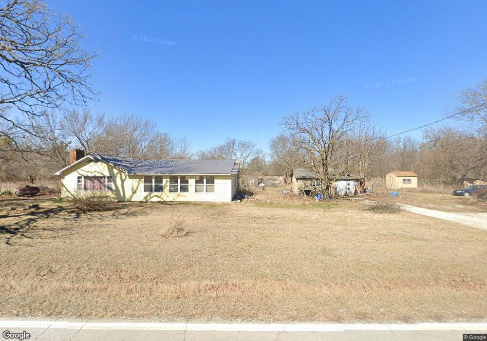
17384 Hwy Mm Unit A Neosho, MO 64850
Estimated Value: $133,237 - $241,000
3
Beds
--
Bath
1,424
Sq Ft
$126/Sq Ft
Est. Value
About This Home
This home is located at 17384 Hwy Mm Unit A, Neosho, MO 64850 and is currently estimated at $178,809, approximately $125 per square foot. 17384 Hwy Mm Unit A is a home located in Newton County with nearby schools including Neosho High School.
Ownership History
Date
Name
Owned For
Owner Type
Purchase Details
Closed on
Mar 6, 2024
Sold by
Donoho Daniel Lee and Donoho Linda
Bought by
Reinke Timothy
Current Estimated Value
Home Financials for this Owner
Home Financials are based on the most recent Mortgage that was taken out on this home.
Original Mortgage
$74,000
Outstanding Balance
$72,783
Interest Rate
6.69%
Mortgage Type
New Conventional
Estimated Equity
$106,026
Purchase Details
Closed on
Feb 21, 2024
Sold by
Donoho Daniel Lee and Donoho Linda
Bought by
Texmo Llc
Home Financials for this Owner
Home Financials are based on the most recent Mortgage that was taken out on this home.
Original Mortgage
$74,000
Outstanding Balance
$72,783
Interest Rate
6.69%
Mortgage Type
New Conventional
Estimated Equity
$106,026
Create a Home Valuation Report for This Property
The Home Valuation Report is an in-depth analysis detailing your home's value as well as a comparison with similar homes in the area
Home Values in the Area
Average Home Value in this Area
Purchase History
| Date | Buyer | Sale Price | Title Company |
|---|---|---|---|
| Reinke Timothy | -- | None Listed On Document | |
| Texmo Llc | -- | None Listed On Document |
Source: Public Records
Mortgage History
| Date | Status | Borrower | Loan Amount |
|---|---|---|---|
| Open | Reinke Timothy | $74,000 | |
| Closed | Texmo Llc | $151,000 |
Source: Public Records
Tax History Compared to Growth
Tax History
| Year | Tax Paid | Tax Assessment Tax Assessment Total Assessment is a certain percentage of the fair market value that is determined by local assessors to be the total taxable value of land and additions on the property. | Land | Improvement |
|---|---|---|---|---|
| 2024 | $675 | $10,350 | -- | -- |
| 2023 | $675 | $12,520 | $5,264 | $7,256 |
| 2022 | $675 | $11,930 | -- | -- |
| 2021 | $642 | $11,930 | $0 | $0 |
| 2020 | $612 | $11,440 | $0 | $0 |
| 2019 | $557 | $11,440 | $0 | $0 |
| 2018 | $737 | $11,490 | $0 | $0 |
| 2017 | $549 | $11,490 | $0 | $0 |
| 2016 | $549 | $11,190 | $0 | $0 |
| 2015 | -- | $11,190 | $0 | $0 |
| 2014 | -- | $10,940 | $0 | $0 |
Source: Public Records
Map
Nearby Homes
- 0000 State Highway Mm
- 000 State Highway Mm
- 8687 Newt Dr
- 16574 Highway Mm
- 16xxx Highway Mm
- 29288 Norway Rd
- 5516 Panda Rd
- Tbd Jasmine Dr
- 407 S Jefferson St
- 534 Bacon Ridge Rd
- 202 N Jefferson St
- 105 N Morgan St
- 203 Locust St
- 404 Maple St
- 404 N Main St
- 13805 Hickory Dr
- 000 Jasmine Dr
- 646 N Random Rd
- 11335 Ozark Rd
- 17384 Highway Mm Unit A
- 17384 Highway Mm Unit C
- 17384 Highway Mm Unit B
- 17384 Highway Mm
- 17384 Hwy Mm Unit B
- 17384 Hwy Mm
- 17384 Highway Mm
- 17449 Highway Mm
- 17448 Highway Mm
- 0 Tbd Highway Mm Unit 216203
- 0 Highway Mm
- 17534 Highway Mm
- 17578 Highway Mm
- 17634 Highway Mm
- 17163 Highway Mm
- 17739 Highway Mm
- 17803 Highway Mm
- 8831 Nighthawk Rd
- 17856 Highway Mm
- 17041 Highway Mm