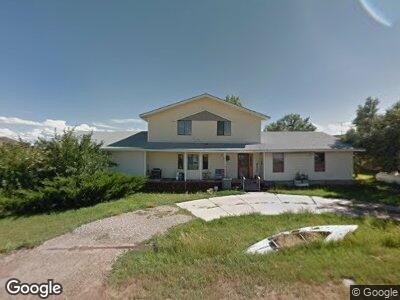
174 Meadow View St Evanston, WY 82930
Estimated Value: $390,946 - $554,000
4
Beds
2
Baths
2,322
Sq Ft
$191/Sq Ft
Est. Value
About This Home
This home is located at 174 Meadow View St, Evanston, WY 82930 and is currently estimated at $443,987, approximately $191 per square foot. 174 Meadow View St is a home located in Uinta County with nearby schools including Evanston High School.
Ownership History
Date
Name
Owned For
Owner Type
Purchase Details
Closed on
Dec 15, 2008
Sold by
The Migroup Inc
Bought by
Frame Alexander B and Frame Rebecca
Current Estimated Value
Home Financials for this Owner
Home Financials are based on the most recent Mortgage that was taken out on this home.
Original Mortgage
$215,160
Interest Rate
6.15%
Mortgage Type
FHA
Purchase Details
Closed on
Aug 2, 2005
Sold by
May Ernest R and May Carol J
Bought by
Stogner Mare A and Stogner Carey R
Home Financials for this Owner
Home Financials are based on the most recent Mortgage that was taken out on this home.
Original Mortgage
$156,750
Interest Rate
5.55%
Mortgage Type
New Conventional
Create a Home Valuation Report for This Property
The Home Valuation Report is an in-depth analysis detailing your home's value as well as a comparison with similar homes in the area
Home Values in the Area
Average Home Value in this Area
Purchase History
| Date | Buyer | Sale Price | Title Company |
|---|---|---|---|
| Frame Alexander B | -- | None Available | |
| Stogner Mare A | -- | None Available | |
| Stogner Marc A | -- | None Available |
Source: Public Records
Mortgage History
| Date | Status | Borrower | Loan Amount |
|---|---|---|---|
| Open | Frame Alexander B | $197,598 | |
| Closed | Frame Alexander B | $215,160 | |
| Previous Owner | Stogner Marc A | $30,000 | |
| Previous Owner | Stogner Marc A | $156,750 | |
| Previous Owner | May Ernest R | $119,000 |
Source: Public Records
Tax History Compared to Growth
Tax History
| Year | Tax Paid | Tax Assessment Tax Assessment Total Assessment is a certain percentage of the fair market value that is determined by local assessors to be the total taxable value of land and additions on the property. | Land | Improvement |
|---|---|---|---|---|
| 2024 | $1,859 | $29,528 | $2,135 | $27,393 |
| 2023 | $1,792 | $28,601 | $2,249 | $26,352 |
| 2022 | $1,572 | $24,922 | $2,015 | $22,907 |
| 2021 | $1,405 | $22,418 | $2,265 | $20,153 |
| 2020 | $1,223 | $19,524 | $2,265 | $17,259 |
| 2019 | $1,487 | $23,795 | $2,265 | $21,530 |
| 2018 | $0 | $18,384 | $2,265 | $16,119 |
| 2017 | $1,127 | $18,053 | $2,206 | $15,847 |
| 2016 | $992 | $15,864 | $2,206 | $13,658 |
| 2015 | -- | $16,118 | $2,049 | $14,069 |
| 2014 | -- | $16,235 | $2,049 | $14,186 |
Source: Public Records
Map
Nearby Homes
- 1363 Almy Road 105
- 247 Loop Rd
- 246 Loop Rd
- 301 Mustang
- 519 County Rd
- 154 2nd Ave
- 190 Mountain Rd
- 300 N Deer Mountain Rd
- 148 Benjamin Franklin St
- 334 N Deer Mountain Rd
- 100 Colonial Ave
- 509 County Rd
- 1617 W Center St
- 432 15th St
- 222 Roosevelt Ave
- 1348 Center St
- 113 Sandstone Dr
- 117 Sandstone Dr
- 725 12th St
- Lot 73 High Point Ranch
- 174 Meadow View St
- 152 Meadow View St
- 151 Meadow View St
- 30 Village Dr
- 177 Meadow View St
- 130 Meadow View St
- 52 Village Dr
- 102 Meadow View St
- 75 Village Dr
- 58 Country Way
- 94 Meadow View St
- 74 Country Way
- 104 Village Dr
- 126 Village Dr
- 118 Country Way
- 15 Country Way
- 15 Country Way Unit Almy Rd 105
- 126 Country Way
- 61 Country Way
- 79 Country Way