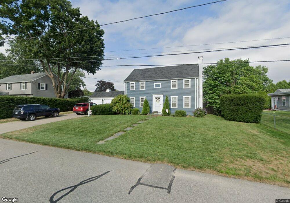
174 Merrymount Dr Warwick, RI 02888
Palace Garden NeighborhoodEstimated Value: $509,910 - $662,000
3
Beds
2
Baths
1,736
Sq Ft
$327/Sq Ft
Est. Value
About This Home
This home is located at 174 Merrymount Dr, Warwick, RI 02888 and is currently estimated at $568,228, approximately $327 per square foot. 174 Merrymount Dr is a home located in Kent County with nearby schools including St. Peter School and Saint Paul School.
Ownership History
Date
Name
Owned For
Owner Type
Purchase Details
Closed on
Sep 8, 2017
Sold by
Chapman Kristine B and Bishop William S
Bought by
Ryan Matthew C and Sullivan-Ryan Lindsay V
Current Estimated Value
Home Financials for this Owner
Home Financials are based on the most recent Mortgage that was taken out on this home.
Original Mortgage
$237,500
Outstanding Balance
$196,528
Interest Rate
3.92%
Mortgage Type
New Conventional
Estimated Equity
$371,700
Create a Home Valuation Report for This Property
The Home Valuation Report is an in-depth analysis detailing your home's value as well as a comparison with similar homes in the area
Home Values in the Area
Average Home Value in this Area
Purchase History
| Date | Buyer | Sale Price | Title Company |
|---|---|---|---|
| Ryan Matthew C | $250,000 | -- |
Source: Public Records
Mortgage History
| Date | Status | Borrower | Loan Amount |
|---|---|---|---|
| Open | Ryan Matthew C | $237,500 |
Source: Public Records
Tax History
| Year | Tax Paid | Tax Assessment Tax Assessment Total Assessment is a certain percentage of the fair market value that is determined by local assessors to be the total taxable value of land and additions on the property. | Land | Improvement |
|---|---|---|---|---|
| 2025 | $5,550 | $437,000 | $138,600 | $298,400 |
| 2024 | $5,525 | $381,800 | $120,500 | $261,300 |
| 2023 | $5,418 | $381,800 | $120,500 | $261,300 |
| 2022 | $5,289 | $282,400 | $77,300 | $205,100 |
| 2021 | $5,289 | $282,400 | $77,300 | $205,100 |
| 2020 | $5,051 | $269,700 | $77,300 | $192,400 |
| 2019 | $5,051 | $269,700 | $77,300 | $192,400 |
| 2018 | $4,025 | $219,400 | $70,600 | $148,800 |
| 2017 | $4,441 | $219,400 | $70,600 | $148,800 |
| 2016 | $4,441 | $219,400 | $70,600 | $148,800 |
| 2015 | $4,872 | $234,800 | $84,200 | $150,600 |
| 2014 | $4,710 | $234,800 | $84,200 | $150,600 |
| 2013 | $4,647 | $234,800 | $84,200 | $150,600 |
Source: Public Records
Map
Nearby Homes
- 15 Shadbush Rd
- 179 Lane 4
- 375 Namquid Dr
- 40 Lane 1
- 68 Lane 5
- 48 Lane 2
- 52 Dahlia St
- 80 Twin Oak Dr
- 72 W Shore Rd Unit 104
- 72 W Shore Rd Unit 3
- 34 N Country Club Dr
- 1020 Warwick Ave
- 408 Fair St
- 63 Ramblewood Dr
- 20 Commodore Ave
- 63 Benbridge Ave
- 55 Dixie Ave
- 56 Errol St
- 15 Christopher Rhodes Way
- 6 Christopher Rhodes Way
- 400 Algonquin Dr
- 164 Merrymount Dr
- 61 Crowfield Dr
- 164 Merry Mount Dr
- 175 Merry Mount Dr
- 175 Merrymount Dr
- 53 Crowfield Dr
- 165 Merrymount Dr
- 410 Algonquin Dr
- 154 Merrymount Dr
- 380 Algonquin Dr
- 153 Merry Mount Dr
- 43 Crowfield Dr
- 153 Merrymount Dr
- 64 Crowfield Dr
- 409 Algonquin Dr
- 422 Spring Green Rd
- 424 Algonquin Dr
- 432 Spring Green Rd
- 399 Algonquin Dr
Your Personal Tour Guide
Ask me questions while you tour the home.