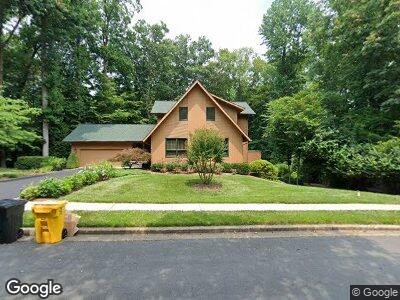
1741 Point no Point Dr Annapolis, MD 21401
Parole NeighborhoodEstimated Value: $882,951 - $1,242,000
--
Bed
3
Baths
2,481
Sq Ft
$408/Sq Ft
Est. Value
About This Home
This home is located at 1741 Point no Point Dr, Annapolis, MD 21401 and is currently estimated at $1,013,488, approximately $408 per square foot. 1741 Point no Point Dr is a home located in Anne Arundel County with nearby schools including Rolling Knolls Elementary School, Wiley H. Bates Middle School, and Annapolis High School.
Ownership History
Date
Name
Owned For
Owner Type
Purchase Details
Closed on
Oct 27, 2023
Sold by
Adams Leslie M and Adams Patricia G
Bought by
Leslie Maynard Adams Revocable Trust and Adams
Current Estimated Value
Purchase Details
Closed on
Dec 21, 1983
Bought by
Adams Leslie M and Adams Patricia G
Home Financials for this Owner
Home Financials are based on the most recent Mortgage that was taken out on this home.
Original Mortgage
$155,250
Interest Rate
13.42%
Create a Home Valuation Report for This Property
The Home Valuation Report is an in-depth analysis detailing your home's value as well as a comparison with similar homes in the area
Home Values in the Area
Average Home Value in this Area
Purchase History
| Date | Buyer | Sale Price | Title Company |
|---|---|---|---|
| Leslie Maynard Adams Revocable Trust | -- | None Listed On Document | |
| Adams Leslie M | $172,500 | -- |
Source: Public Records
Mortgage History
| Date | Status | Borrower | Loan Amount |
|---|---|---|---|
| Previous Owner | Adams Patricia G | $225,000 | |
| Previous Owner | Adams Patricia G | $100,000 | |
| Previous Owner | Adams Patricia G | $100,000 | |
| Previous Owner | Adams Leslie M | $179,999 | |
| Previous Owner | Adams Leslie M | $155,250 |
Source: Public Records
Tax History Compared to Growth
Tax History
| Year | Tax Paid | Tax Assessment Tax Assessment Total Assessment is a certain percentage of the fair market value that is determined by local assessors to be the total taxable value of land and additions on the property. | Land | Improvement |
|---|---|---|---|---|
| 2024 | $6,618 | $755,433 | $0 | $0 |
| 2023 | $6,396 | $682,367 | $0 | $0 |
| 2022 | $5,944 | $609,300 | $339,400 | $269,900 |
| 2021 | $11,672 | $596,533 | $0 | $0 |
| 2020 | $5,692 | $583,767 | $0 | $0 |
| 2019 | $5,592 | $571,000 | $266,400 | $304,600 |
| 2018 | $5,790 | $571,000 | $266,400 | $304,600 |
| 2017 | $5,283 | $571,000 | $0 | $0 |
| 2016 | -- | $596,700 | $0 | $0 |
| 2015 | -- | $596,700 | $0 | $0 |
| 2014 | -- | $596,700 | $0 | $0 |
Source: Public Records
Map
Nearby Homes
- 110 Lancaster Ct
- 1486 Downham Market
- 1735 Broadlee Trail
- 319 Epping Way
- 327 Riverview Trail
- 515 Corbin Pkwy
- 55 Harbour Heights Dr
- 91 Harbour Heights Dr
- 336 Severn Rd
- 856 St Edmonds Place
- 2175 Glencrest Cir
- 631 Admiral Dr Unit 303
- 2063 Old Admiral Ct
- 2065 Old Admiral Ct
- 2000 Phillips Terrace Unit 12
- 2073 Old Admiral Ct
- 524 Ridge Rd
- 621 Admiral Dr Unit 207
- 2565 Housley Rd
- 806 Coachway
- 1741 Point no Point Dr
- 1745 Point no Point Dr
- 1744 Point no Point Dr
- 529 Saltworks Ct
- 1740 Point no Point Dr
- 1748 Point no Point Dr
- 1737 Point no Point Dr
- 528 Saltworks Ct
- 532 Saltworks Ct
- 1736 Point no Point Dr
- 525 Saltworks Ct
- 1749 Point no Point Dr
- 1752 Point no Point Dr
- 524 Saltworks Ct
- 1733 Point no Point Dr
- 541 Choptank Cove Ct
- 545 Choptank Cove Ct
- 549 Choptank Cove Ct
- 553 Choptank Cove Ct
- 1753 Point no Point Dr