
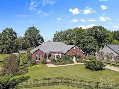


17427 Purser Dr Locust, NC 28097
Estimated payment $2,668/month
Highlights
- Open Floorplan
- Ranch Style House
- Covered Patio or Porch
- Locust Elementary School Rated A-
- No HOA
- Laundry Room
About This Home
Beautiful well maintained full Brick ranch! Gardeners Paradise! Ornamental trees, flowers, shrubs, and raised bed gardens in the back yard. Come home and enjoy your completely fenced property and private backyard oasis just minutes from town. Spacious kitchen with stainless steel appliances and living area with connected second complete living area with full kitchen and bathroom,bedroom and living room with separate entrance.Newer HVAC and water heater. Three spacious storage sheds, one of the sheds is 10 x 20 with two lofts a workbench and fully wired.Enough room to store all of your tools and toys. Don’t miss your chance to own a slice of paradise!
Listing Agent
Realty One Group Revolution Brokerage Email: matthewmyersyourrealtor@gmail.com License #220910 Listed on: 09/30/2025

Home Details
Home Type
- Single Family
Year Built
- Built in 2007
Lot Details
- 0.61 Acre Lot
- Back and Front Yard Fenced
Parking
- Driveway
Home Design
- Ranch Style House
- Four Sided Brick Exterior Elevation
Interior Spaces
- 2,409 Sq Ft Home
- Open Floorplan
- Gas Log Fireplace
- Living Room with Fireplace
- Crawl Space
- Permanent Attic Stairs
Kitchen
- Electric Oven
- Electric Range
- Range Hood
- Dishwasher
Bedrooms and Bathrooms
- 4 Main Level Bedrooms
- Split Bedroom Floorplan
- 3 Full Bathrooms
Laundry
- Laundry Room
- Dryer
Outdoor Features
- Covered Patio or Porch
Utilities
- Central Air
- Air Filtration System
- Vented Exhaust Fan
- Heat Pump System
- Electric Water Heater
- Septic Tank
- Cable TV Available
Community Details
- No Home Owners Association
- Ridgecrest Acres Subdivision
Listing and Financial Details
- Assessor Parcel Number 5597-03-33-1076
Map
Home Values in the Area
Average Home Value in this Area
Tax History
| Year | Tax Paid | Tax Assessment Tax Assessment Total Assessment is a certain percentage of the fair market value that is determined by local assessors to be the total taxable value of land and additions on the property. | Land | Improvement |
|---|---|---|---|---|
| 2025 | $2,178 | $330,065 | $42,500 | $287,565 |
| 2024 | $3,536 | $252,184 | $22,500 | $229,684 |
| 2023 | $2,613 | $252,184 | $22,500 | $229,684 |
| 2022 | $1,793 | $248,976 | $22,500 | $226,476 |
| 2021 | $1,793 | $248,976 | $22,500 | $226,476 |
| 2020 | $1,718 | $222,534 | $18,000 | $204,534 |
| 2019 | $1,736 | $222,534 | $18,000 | $204,534 |
| 2018 | $282 | $222,534 | $18,000 | $204,534 |
| 2017 | $1,736 | $222,534 | $18,000 | $204,534 |
| 2016 | $1,644 | $216,298 | $18,000 | $198,298 |
| 2015 | $1,661 | $216,298 | $18,000 | $198,298 |
| 2014 | $1,653 | $216,298 | $18,000 | $198,298 |
Property History
| Date | Event | Price | List to Sale | Price per Sq Ft |
|---|---|---|---|---|
| 02/18/2026 02/18/26 | Pending | -- | -- | -- |
| 11/11/2025 11/11/25 | Price Changed | $482,650 | -2.5% | $200 / Sq Ft |
| 10/06/2025 10/06/25 | Price Changed | $495,000 | -3.9% | $205 / Sq Ft |
| 09/30/2025 09/30/25 | For Sale | $515,000 | -- | $214 / Sq Ft |
Purchase History
| Date | Type | Sale Price | Title Company |
|---|---|---|---|
| Warranty Deed | $120,000 | None Available | |
| Warranty Deed | $240,000 | None Available | |
| Warranty Deed | $23,000 | None Available |
Mortgage History
| Date | Status | Loan Amount | Loan Type |
|---|---|---|---|
| Open | $15,000 | Credit Line Revolving |
Source: Canopy MLS (Canopy Realtor® Association)
MLS Number: 4307736
APN: 5597-03-33-1076
Disclaimer: Certain information contained herein is derived from information provided by parties other than Homes.com. All information provided is deemed reliable, but is not guaranteed to be accurate and should be independently verified.
![]() All data is obtained from various sources and may not have been verified by broker or MLS GRID. Supplied Open House Information is subject to change without notice. All information should be independently reviewed and verified for accuracy. Properties may or may not be listed by the office/agent presenting the information. Some IDX listings have been excluded from this website.
All data is obtained from various sources and may not have been verified by broker or MLS GRID. Supplied Open House Information is subject to change without notice. All information should be independently reviewed and verified for accuracy. Properties may or may not be listed by the office/agent presenting the information. Some IDX listings have been excluded from this website.
Based on information submitted to the MLS GRID
- Parcel 2 Birdhouse Ln
- Parcel 1 Birdhouse Ln
- 24910 Birdhouse Ln Unit 1
- 16659 Five Point Rd
- 00 Millingport Rd Unit 1
- 20313 Running Creek Church Rd
- 21080 Running Creek Dr
- 21072 Running Creek Dr
- 21064 Running Creek Dr
- 20289 Running Creek Church Rd
- 21056 Running Creek Dr
- 20420 Ridgecrest Rd
- 21048 Running Creek Dr
- 137 Soft Breeze Bend Unit 283b
- 155 Soft Breeze Bend Unit 286b
- Red Cedar Plan at Running Creek
- Rainier Plan at Running Creek
- Elliott Plan at Running Creek
- Roosevelt Plan at Running Creek
- 13271 Austin Rd
Ask me questions while you tour the home.