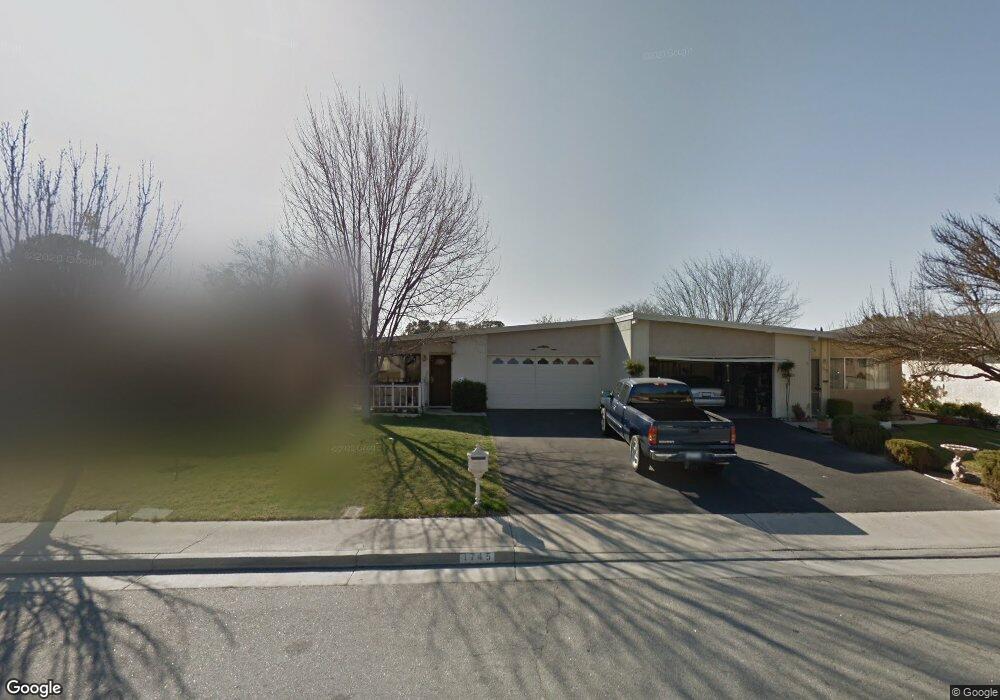
1745 Shepherd Dr Paso Robles, CA 93446
Estimated Value: $432,000 - $448,000
About This Home
This home is located at 1745 Shepherd Dr, Paso Robles, CA 93446 and is currently estimated at $438,193, approximately $486 per square foot. 1745 Shepherd Dr is a home located in San Luis Obispo County with nearby schools including Virginia Peterson Elementary School, Daniel Lewis Middle School, and Paso Robles High School.
Ownership History
We collect this data history from publicly available records. To have your information removed, we recommend requesting removal directly through your county’s website.
Purchase Details
Home Financials for this Owner
Home Financials are based on the most recent Mortgage that was taken out on this home.Purchase Details
Purchase Details
Home Financials for this Owner
Home Financials are based on the most recent Mortgage that was taken out on this home.Purchase History
We collect this data history from publicly available records. To have your information removed, we recommend requesting removal directly through your county’s website.
| Date | Buyer | Sale Price | Title Company |
|---|---|---|---|
| $230,000 | Cuesta Title | ||
| -- | Cuesta Title Company | ||
| $105,000 | First American Title Ins Co |
Mortgage History
We collect this data history from publicly available records. To have your information removed, we recommend requesting removal directly through your county’s website.
| Date | Status | Borrower | Loan Amount |
|---|---|---|---|
| Open | $184,000 | ||
| Previous Owner | $84,000 |
Tax History
We collect this data history from publicly available records. To have your information removed, we recommend requesting removal directly through your county’s website.
| Year | Tax Paid | Tax Assessment Tax Assessment Total Assessment is a certain percentage of the fair market value that is determined by local assessors to be the total taxable value of land and additions on the property. | Land | Improvement |
|---|---|---|---|---|
| 2025 | $3,281 | $308,138 | $154,069 | $154,069 |
| 2024 | $3,226 | $302,098 | $151,049 | $151,049 |
| 2023 | $3,226 | $296,176 | $148,088 | $148,088 |
| 2022 | $3,176 | $290,370 | $145,185 | $145,185 |
| 2021 | $3,120 | $284,678 | $142,339 | $142,339 |
| 2020 | $3,156 | $281,760 | $140,880 | $140,880 |
| 2019 | $3,111 | $276,236 | $138,118 | $138,118 |
| 2018 | $3,069 | $270,820 | $135,410 | $135,410 |
| 2017 | $2,885 | $265,510 | $132,755 | $132,755 |
| 2016 | $2,576 | $237,000 | $120,000 | $117,000 |
| 2015 | $2,451 | $223,000 | $110,000 | $113,000 |
| 2014 | $2,359 | $218,000 | $110,000 | $108,000 |
Map
- 1740 Westfield Rd
- 618 Queenanne Rd
- 503 Turtle Creek Rd
- 805 Turtle Creek Rd
- 1843 Ponderosa Ln
- 1945 Fieldstone Cir
- 902 Larable Ct
- 2385 Larkfield Place
- 5185 Airport Rd
- 309 Camino Lobo
- 358 Via Ramona
- 1934 Tulipwood Dr
- 1032 Scott St
- 903 Running Stag Way
- 1199 Jaden Ln
- 3725 Rosado Rd
- 2468 Falcon Dr
- 3731 Rosado Rd
- 1218 Olive Hill Rd
- 1171 Mazzini Rd
- 1736 Westfield Rd
- 1734 Westfield Rd
- 1802 Westfield Rd
- 1732 Westfield Rd
- 1763 Shepherd Dr
- 1757 Shepherd Dr
- 1761 Shepherd Dr
- 1804 Westfield Rd
- 1755 Shepherd Dr
- 1730 Westfield Rd
- 1751 Shepherd Dr
- 1805 Shepherd Dr
- 1808 Westfield Rd
- 1739 Westfield Rd
- 1749 Shepherd Dr
- 1735 Westfield Rd
- 1801 Westfield Rd
- 1807 Shepherd Dr
- 1728 Westfield Rd
- 1803 Westfield Rd
Ask me questions while you tour the home.