Estimated Value: $422,889 - $475,000
3
Beds
2
Baths
1,190
Sq Ft
$384/Sq Ft
Est. Value
About This Home
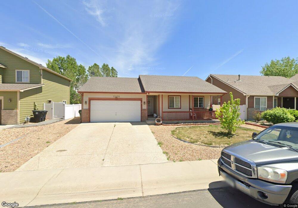
This home is located at 17450 Margil Rd, Mead, CO 80542 and is currently estimated at $456,472, approximately $383 per square foot. 17450 Margil Rd is a home located in Weld County with nearby schools including Mead Elementary School, Mead Middle School, and Mead High School.
Ownership History
Date
Name
Owned For
Owner Type
Purchase Details
Closed on
Nov 13, 2014
Sold by
Redmon Johnny
Bought by
Redmon Johnny and Redmon Judy
Current Estimated Value
Purchase Details
Closed on
May 28, 2009
Sold by
Garland Mark D and Garland Tabitha L
Bought by
Redmon Johnny
Home Financials for this Owner
Home Financials are based on the most recent Mortgage that was taken out on this home.
Original Mortgage
$182,631
Outstanding Balance
$115,327
Interest Rate
4.76%
Mortgage Type
FHA
Estimated Equity
$341,145
Purchase Details
Closed on
Jul 27, 2004
Sold by
J & J Construction Northern Colorado Llc
Bought by
Garland Mark D and Garland Tabitha L
Home Financials for this Owner
Home Financials are based on the most recent Mortgage that was taken out on this home.
Original Mortgage
$167,530
Interest Rate
6.3%
Mortgage Type
Unknown
Create a Home Valuation Report for This Property
The Home Valuation Report is an in-depth analysis detailing your home's value as well as a comparison with similar homes in the area
Home Values in the Area
Average Home Value in this Area
Purchase History
| Date | Buyer | Sale Price | Title Company |
|---|---|---|---|
| Redmon Johnny | -- | Land Title Guarantee Company | |
| Redmon Johnny | $186,000 | Land Title Guarantee Company | |
| Garland Mark D | $186,145 | -- |
Source: Public Records
Mortgage History
| Date | Status | Borrower | Loan Amount |
|---|---|---|---|
| Open | Redmon Johnny | $182,631 | |
| Previous Owner | Garland Mark D | $167,530 |
Source: Public Records
Tax History Compared to Growth
Tax History
| Year | Tax Paid | Tax Assessment Tax Assessment Total Assessment is a certain percentage of the fair market value that is determined by local assessors to be the total taxable value of land and additions on the property. | Land | Improvement |
|---|---|---|---|---|
| 2025 | $2,142 | $25,770 | $8,630 | $17,140 |
| 2024 | $2,142 | $25,770 | $8,630 | $17,140 |
| 2023 | $2,065 | $24,040 | $4,940 | $19,100 |
| 2022 | $2,274 | $21,300 | $5,070 | $16,230 |
| 2021 | $2,317 | $21,910 | $5,220 | $16,690 |
| 2020 | $2,927 | $21,300 | $4,500 | $16,800 |
| 2019 | $2,231 | $21,300 | $4,500 | $16,800 |
| 2018 | $1,858 | $17,930 | $3,460 | $14,470 |
| 2017 | $2,600 | $17,930 | $3,460 | $14,470 |
| 2016 | $1,597 | $15,900 | $3,180 | $12,720 |
| 2015 | $1,549 | $15,900 | $3,180 | $12,720 |
| 2014 | $1,213 | $12,290 | $3,180 | $9,110 |
Source: Public Records
Map
Nearby Homes
- 3757 Settler Ridge Dr
- 17635 Silver Fox Ct
- 3796 Vale View Ln
- 102 Cattail Ct
- 215 Willow Dr
- 4326 County Road 38
- 16835 Mckay Dr
- 16870 Mckay Dr
- Silverton Plan at Highlands Preserve
- Jefferson Plan at Highlands Preserve
- Keystone II Plan at Highlands Preserve
- Minturn Plan at Highlands Preserve
- Lakewood II Plan at Highlands Preserve
- Jansen Plan at Highlands Preserve
- Gunnison Plan at Highlands Preserve
- Jackson Plan at Highlands Preserve
- 3425 Ballinger Cir
- 17790 County Road 7
- 16836 Roberts St
- 16860 Mckay Dr
- 17438 Margil Rd
- 17462 Margil Rd
- 17426 Margil Rd
- 3753 Homestead Dr
- 3775 Homestead Dr
- 3791 Homestead Dr
- 17414 Margil Rd
- 17475 Margil Rd
- 17463 Margil Rd
- 17451 Margil Rd
- 17487 Margil Rd
- 17474 Margil Rd
- 17402 Margil Rd
- 3821 Homestead Dr
- 17447 Margil Rd
- 17499 Margil Rd
- 17350 Margil Rd
- 17439 Margil Rd
- 17486 Margil Rd
- 3835 Homestead Dr