Estimated Value: $494,000 - $530,000
4
Beds
3
Baths
1,576
Sq Ft
$325/Sq Ft
Est. Value
About This Home
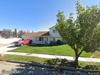
This home is located at 1746 N 1900 W, Lehi, UT 84043 and is currently estimated at $512,672, approximately $325 per square foot. 1746 N 1900 W is a home located in Utah County with nearby schools including North Point Elementary School, Willowcreek Middle School, and Lehi High School.
Ownership History
Date
Name
Owned For
Owner Type
Purchase Details
Closed on
Nov 21, 2003
Sold by
Fannie Mae
Bought by
Erling Dawn K
Current Estimated Value
Home Financials for this Owner
Home Financials are based on the most recent Mortgage that was taken out on this home.
Original Mortgage
$106,400
Interest Rate
5.89%
Mortgage Type
Purchase Money Mortgage
Purchase Details
Closed on
Sep 12, 2003
Sold by
Citimortgage Inc
Bought by
Federal National Mortgage Association
Purchase Details
Closed on
Aug 21, 2003
Sold by
Rodgers Paul D
Bought by
Citimortgage Inc
Purchase Details
Closed on
Mar 22, 2001
Sold by
Rodgers Paul D and Rodgers Wendy
Bought by
Loveless Phillip B and Loveless Myrna L
Home Financials for this Owner
Home Financials are based on the most recent Mortgage that was taken out on this home.
Original Mortgage
$150,000
Interest Rate
7.06%
Mortgage Type
Seller Take Back
Purchase Details
Closed on
Mar 24, 2000
Sold by
Rodgers Paul D
Bought by
Rodgers Paul D and Rodgers Wendy
Home Financials for this Owner
Home Financials are based on the most recent Mortgage that was taken out on this home.
Original Mortgage
$137,000
Interest Rate
8.38%
Purchase Details
Closed on
Feb 14, 2000
Sold by
Rodgers Paul D
Bought by
Rodgers Paul D and Rodgers Wendy
Home Financials for this Owner
Home Financials are based on the most recent Mortgage that was taken out on this home.
Original Mortgage
$137,000
Interest Rate
8.38%
Purchase Details
Closed on
Feb 26, 1999
Sold by
Rodgers Paul D
Bought by
Rodgers Paul D and Rodgers Wendy
Home Financials for this Owner
Home Financials are based on the most recent Mortgage that was taken out on this home.
Original Mortgage
$118,800
Interest Rate
9.12%
Purchase Details
Closed on
Feb 4, 1999
Sold by
Stuart Charles J
Bought by
Rodgers Paul D
Home Financials for this Owner
Home Financials are based on the most recent Mortgage that was taken out on this home.
Original Mortgage
$118,800
Interest Rate
9.12%
Purchase Details
Closed on
Jan 12, 1999
Sold by
Salisbury Development Lc
Bought by
Stuart Charles J
Home Financials for this Owner
Home Financials are based on the most recent Mortgage that was taken out on this home.
Original Mortgage
$118,800
Interest Rate
9.12%
Create a Home Valuation Report for This Property
The Home Valuation Report is an in-depth analysis detailing your home's value as well as a comparison with similar homes in the area
Home Values in the Area
Average Home Value in this Area
Purchase History
| Date | Buyer | Sale Price | Title Company |
|---|---|---|---|
| Erling Dawn K | -- | Empire Land Title Company | |
| Federal National Mortgage Association | -- | Mountain West Title Co | |
| Citimortgage Inc | $132,822 | Mountain West Title Co | |
| Loveless Phillip B | -- | Fidelity Land & Title | |
| Rodgers Paul D | -- | Fidelity Land & Title | |
| Rodgers Paul D | -- | Fidelity Land & Title | |
| Rodgers Paul D | -- | Fidelity Land & Title | |
| Rodgers Paul D | -- | Fidelity Land & Title | |
| Rodgers Paul D | -- | Fidelity Land & Title | |
| Rodgers Paul D | -- | Fidelity Land & Title | |
| Stuart Charles J | -- | Fidelity Land & Title |
Source: Public Records
Mortgage History
| Date | Status | Borrower | Loan Amount |
|---|---|---|---|
| Open | Erling Dawn K | $260,000 | |
| Closed | Erling Dawn K | $173,800 | |
| Closed | Erling Dawn K | $164,326 | |
| Closed | Erling Dawn K | $132,500 | |
| Closed | Erling Dawn K | $29,000 | |
| Closed | Erling Dawn K | $106,400 | |
| Previous Owner | Loveless Phillip B | $150,000 | |
| Previous Owner | Rodgers Paul D | $137,000 | |
| Previous Owner | Rodgers Paul D | $136,500 | |
| Previous Owner | Rodgers Paul D | $118,800 | |
| Closed | Erling Dawn K | $26,600 |
Source: Public Records
Tax History Compared to Growth
Tax History
| Year | Tax Paid | Tax Assessment Tax Assessment Total Assessment is a certain percentage of the fair market value that is determined by local assessors to be the total taxable value of land and additions on the property. | Land | Improvement |
|---|---|---|---|---|
| 2024 | $2,018 | $236,115 | $0 | $0 |
| 2023 | $1,840 | $233,805 | $0 | $0 |
| 2022 | $2,031 | $250,195 | $0 | $0 |
| 2021 | $1,795 | $334,300 | $119,900 | $214,400 |
| 2020 | $1,692 | $311,400 | $111,000 | $200,400 |
| 2019 | $1,491 | $285,400 | $111,000 | $174,400 |
| 2018 | $1,410 | $255,000 | $99,000 | $156,000 |
| 2017 | $1,364 | $131,175 | $0 | $0 |
| 2016 | $1,285 | $114,675 | $0 | $0 |
| 2015 | $1,282 | $108,625 | $0 | $0 |
| 2014 | $1,178 | $99,165 | $0 | $0 |
Source: Public Records
Map
Nearby Homes
- 1992 N 2090 St W
- 1971 N 2090 St W
- 2014 N 2090 St W
- 1972 2160 St W
- 2015 N 2090 St W
- 1972 N 2160 St W
- 1994 N 2160 St W
- 2016 N 2160 St W
- 2246 W 2000 St N
- 2240 W 2000 St N
- 1460 N 1700 W Unit 101
- 1700 N 2340 W
- 1919 N 2280 St W
- 1919 N 2280 St W
- 1919 N 2280 St W
- 1919 N 2280 St W
- 1659 W Boxwood Dr Unit 109
- 1685 W 1500 N Unit 102
- 1627 W Boxwood Dr Unit 110
- 1898 W Pointe Meadow Loop