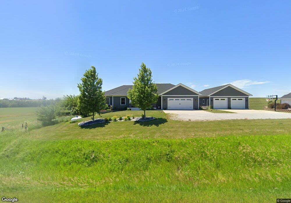
1747 Baker Ave West Branch, IA 52358
Estimated Value: $426,000 - $773,142
5
Beds
2
Baths
2,217
Sq Ft
$279/Sq Ft
Est. Value
About This Home
This home is located at 1747 Baker Ave, West Branch, IA 52358 and is currently estimated at $618,786, approximately $279 per square foot. 1747 Baker Ave is a home with nearby schools including Hoover Elementary School, West Branch Middle School, and West Branch High School.
Ownership History
Date
Name
Owned For
Owner Type
Purchase Details
Closed on
Jul 16, 2021
Sold by
Michelle Gardner Mindy and Michelle Michael Lee
Bought by
Heintz Brett H and Heintz Shannon J
Current Estimated Value
Home Financials for this Owner
Home Financials are based on the most recent Mortgage that was taken out on this home.
Original Mortgage
$504,000
Outstanding Balance
$375,042
Interest Rate
2.2%
Mortgage Type
New Conventional
Estimated Equity
$243,744
Purchase Details
Closed on
Aug 20, 2008
Sold by
Reichert Jeffrey D and Reichert Joann
Bought by
Stout Kevin P and Stout Marisa E
Create a Home Valuation Report for This Property
The Home Valuation Report is an in-depth analysis detailing your home's value as well as a comparison with similar homes in the area
Home Values in the Area
Average Home Value in this Area
Purchase History
| Date | Buyer | Sale Price | Title Company |
|---|---|---|---|
| Heintz Brett H | $630,000 | None Listed On Document | |
| Stout Kevin P | $33,000 | None Available |
Source: Public Records
Mortgage History
| Date | Status | Borrower | Loan Amount |
|---|---|---|---|
| Open | Heintz Brett H | $504,000 |
Source: Public Records
Tax History Compared to Growth
Tax History
| Year | Tax Paid | Tax Assessment Tax Assessment Total Assessment is a certain percentage of the fair market value that is determined by local assessors to be the total taxable value of land and additions on the property. | Land | Improvement |
|---|---|---|---|---|
| 2025 | $9,034 | $682,680 | $111,600 | $571,080 |
| 2024 | $9,034 | $721,410 | $96,900 | $624,510 |
| 2023 | $8,498 | $692,210 | $96,900 | $595,310 |
| 2022 | $7,152 | $589,890 | $69,190 | $520,700 |
| 2021 | $6,840 | $523,920 | $69,190 | $454,730 |
| 2020 | $6,654 | $465,700 | $61,500 | $404,200 |
| 2019 | $5,556 | $434,970 | $61,500 | $404,200 |
| 2018 | $5,206 | $416,490 | $0 | $0 |
| 2017 | $5,206 | $175,750 | $0 | $0 |
| 2016 | $32 | $2,250 | $0 | $0 |
| 2015 | $32 | $2,250 | $0 | $0 |
| 2014 | $32 | $2,250 | $0 | $0 |
Source: Public Records
Map
Nearby Homes
- 12 Bradley Ln Unit AB12
- 27 Bradley Ln Unit AC27
- 63 Eisenhower St Unit GB63
- 33 Lou Henry Ln Unit AM33
- 35 Lou Henry Ln Unit AM35
- 3 Grant St Unit GR3
- 521 N 4th St Unit Louise Court Condos
- 557 N 4th St
- 121 Northridge Dr Unit 121-139
- 110 Northside Dr
- 0 340th St NE Unit 2507765
- 426 N 1st St
- T.B.D. 275th St
- 4 Lazy Brook Dr
- 2 Lazy Brook Dr
- 1 Ember Ln
- 609 W Orange St
- Lot 17 Meadows Subdivision Part 5
- 611 Riley Ln
- 122 acres m/l Cedar Johnson Rd
- 1745 Baker Ave
- 1743 Baker Ave
- 0 Hwy 30 Unit 2803189
- 1748 Baker Ave
- 0 Baker Ave
- 1754 Baker Ave
- 1758 Baker Ave
- 1766 Baker Ave
- 1764 Baker Ave
- 1760 Baker Ave
- 1762 Baker Ave
- 1723 Baker Ave
- 1784 Baker Ave
- 1786 Baker Ave
- 1788 Baker Ave
- 1716 Baker Ave
- 3 Bradley Ln Unit AA3
- 8 Bradley Ln Unit AA8
- 31 Bradley Ln
- 30 Bradley Ln Unit AD30