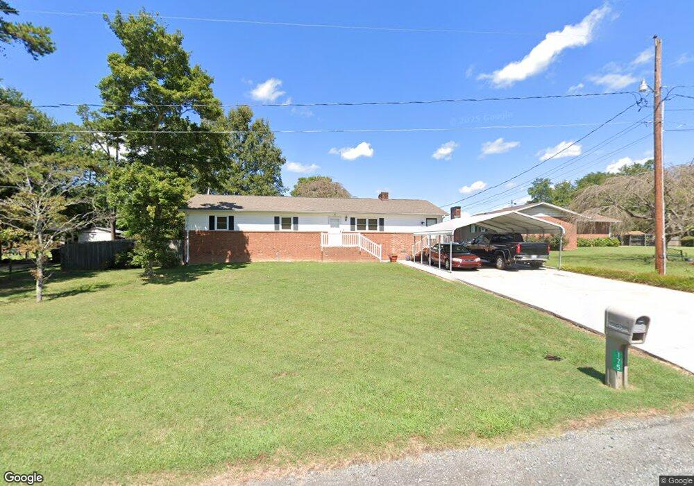
175 E Thomas Dr Thomasville, NC 27360
Estimated Value: $227,639 - $280,000
3
Beds
2
Baths
1,908
Sq Ft
$127/Sq Ft
Est. Value
About This Home
This home is located at 175 E Thomas Dr, Thomasville, NC 27360 and is currently estimated at $243,160, approximately $127 per square foot. 175 E Thomas Dr is a home located in Davidson County with nearby schools including Pilot Elementary School, E. Lawson Brown Middle School, and East Davidson High School.
Ownership History
Date
Name
Owned For
Owner Type
Purchase Details
Closed on
Dec 14, 2020
Sold by
Childress Joe Don
Bought by
Childress Brian Glenn
Current Estimated Value
Purchase Details
Closed on
Mar 20, 2000
Sold by
Homan Nancy Marie
Bought by
Childress Joe D
Purchase Details
Closed on
Jul 1, 1991
Purchase Details
Closed on
Feb 1, 1990
Purchase Details
Closed on
May 1, 1983
Purchase Details
Closed on
Mar 1, 1979
Create a Home Valuation Report for This Property
The Home Valuation Report is an in-depth analysis detailing your home's value as well as a comparison with similar homes in the area
Home Values in the Area
Average Home Value in this Area
Purchase History
| Date | Buyer | Sale Price | Title Company |
|---|---|---|---|
| Childress Brian Glenn | -- | None Available | |
| Childress Brian Glenn | -- | None Listed On Document | |
| Childress Joe D | $98,000 | -- | |
| -- | $75,500 | -- | |
| -- | $65,000 | -- | |
| -- | $45,000 | -- | |
| -- | $37,500 | -- |
Source: Public Records
Tax History
| Year | Tax Paid | Tax Assessment Tax Assessment Total Assessment is a certain percentage of the fair market value that is determined by local assessors to be the total taxable value of land and additions on the property. | Land | Improvement |
|---|---|---|---|---|
| 2025 | $840 | $132,160 | $0 | $0 |
| 2024 | $840 | $132,160 | $0 | $0 |
| 2023 | $814 | $132,160 | $0 | $0 |
| 2022 | $814 | $132,160 | $0 | $0 |
| 2021 | $814 | $132,160 | $0 | $0 |
| 2020 | $673 | $109,320 | $0 | $0 |
| 2019 | $683 | $109,320 | $0 | $0 |
| 2018 | $683 | $109,320 | $0 | $0 |
| 2017 | $683 | $109,320 | $0 | $0 |
| 2016 | $683 | $109,320 | $0 | $0 |
| 2015 | $683 | $109,320 | $0 | $0 |
| 2014 | $751 | $120,120 | $0 | $0 |
Source: Public Records
Map
Nearby Homes
- 3622 Lower Lake Rd
- 189 Panther Ln
- 189 Panther Ln Unit 94-97
- 827 Shell Rd
- 1125 Hillcrest Dr
- 0 Hillcrest Dr Unit 90 CAR4240649
- 170 Garrett Ln
- 328 Conrad Cir
- 596 Colleen Dr
- 6919 E Holly Grove Rd
- 186 Holland Ln
- 164 Holland Ln
- 380 Cedarland Dr
- 205 Bethlehem Ave
- 104 Black Ave
- 311 Pebble Dr
- 113 Circle Dr
- 115 Circle Dr
- 5285 E Holly Grove Rd
- 5285 E Holly Grove Rd Unit 43
- 191 E Thomas Dr
- 153 E Thomas Dr
- 209 E Thomas Dr
- 4640 Lower Lake Rd
- 4614 Lower Lake Rd
- 4594 Lower Lake Rd
- 216 E Thomas Dr
- 235 E Thomas Dr
- 4538 Lower Lake Rd
- 251 E Thomas Dr
- 248 E Thomas Dr
- 4601 Lower Lake Rd
- 4645 Lower Lake Rd
- 2802 Upper Lake Rd
- 2678 Upper Lake Rd
- 4533 Lower Lake Rd
- 2841 Upper Lake Rd
- 153 West Thomas Dr
- 2906 Upper Lake Rd
- 2877 Upper Lake Rd
Your Personal Tour Guide
Ask me questions while you tour the home.