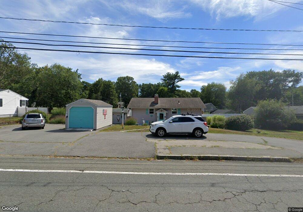
175 Schoosett St Pembroke, MA 02359
Estimated Value: $550,801 - $565,000
--
Bed
2
Baths
1,152
Sq Ft
$484/Sq Ft
Est. Value
About This Home
This home is located at 175 Schoosett St, Pembroke, MA 02359 and is currently estimated at $557,200, approximately $483 per square foot. 175 Schoosett St is a home located in Plymouth County with nearby schools including Pembroke High School, Cadence Academy Preschool - Hanover, and Cardinal Cushing Centers.
Ownership History
Date
Name
Owned For
Owner Type
Purchase Details
Closed on
Jun 14, 2023
Sold by
Gallo William A and Gallo Diane E
Bought by
Diane & William Gallo Ret and Gallo
Current Estimated Value
Purchase Details
Closed on
Jun 23, 1975
Bought by
Gallo William A and Gallo Diane E
Create a Home Valuation Report for This Property
The Home Valuation Report is an in-depth analysis detailing your home's value as well as a comparison with similar homes in the area
Home Values in the Area
Average Home Value in this Area
Purchase History
| Date | Buyer | Sale Price | Title Company |
|---|---|---|---|
| Diane & William Gallo Ret | -- | None Available | |
| Gallo William A | -- | -- |
Source: Public Records
Mortgage History
| Date | Status | Borrower | Loan Amount |
|---|---|---|---|
| Previous Owner | Gallo William A | $42,000 | |
| Previous Owner | Gallo William A | $50,000 | |
| Previous Owner | Gallo William A | $38,000 |
Source: Public Records
Tax History Compared to Growth
Tax History
| Year | Tax Paid | Tax Assessment Tax Assessment Total Assessment is a certain percentage of the fair market value that is determined by local assessors to be the total taxable value of land and additions on the property. | Land | Improvement |
|---|---|---|---|---|
| 2025 | $5,909 | $491,600 | $273,200 | $218,400 |
| 2024 | $5,587 | $464,400 | $247,500 | $216,900 |
| 2023 | $5,552 | $436,500 | $235,300 | $201,200 |
| 2022 | $5,115 | $361,500 | $194,000 | $167,500 |
| 2021 | $4,889 | $335,300 | $181,500 | $153,800 |
| 2020 | $4,798 | $331,100 | $177,500 | $153,600 |
| 2019 | $4,719 | $323,200 | $173,300 | $149,900 |
| 2018 | $4,428 | $297,400 | $165,900 | $131,500 |
| 2017 | $4,314 | $285,700 | $154,200 | $131,500 |
| 2016 | $4,106 | $269,100 | $142,200 | $126,900 |
| 2015 | $3,769 | $255,700 | $134,300 | $121,400 |
Source: Public Records
Map
Nearby Homes
- 46 Lorna Ave
- 218 Schoosett St
- 172 Washington St
- 55 Shipyard Ln
- 133 Brigantine Cir
- 261 Washington St
- 15 Kings Terrace
- 28 Old Shipyard Ln
- 33 Barker Square Dr Unit 33
- 20 Meadow Brook Rd
- 21 Union St
- 31 Hillcrest Dr
- 21 Chowdermarch St
- 66 Hemlock Dr
- 5 Royal Dane Dr Unit 46
- 16 Broad Oak Way
- 10 Royal Dane Dr Unit 88
- 26 Church St
- 15 Bagnell Dr Unit 15
- 180 Elm St
- 179 Schoosett St
- 171 Schoosett St
- 23 Burr Ave
- 19 Burr Ave
- 51 Lorna Ave
- 183 Schoosett St
- 166 Schoosett St Unit Top Floor
- 166 Schoosett St Unit 1-C
- 166 Schoosett St Unit 1-A
- 166 Schoosett St Unit 2-A
- 166 Schoosett St Unit 1 & U:1A
- 166 Schoosett St Unit LL
- 166 Schoosett St Unit Apartment
- 166 Schoosett St
- 166 Schoosett St Unit Upper
- 13 Burr Ave
- 167 Schoosett St
- 56 Lorna Ave
- 22 Burr Ave
- 47 Lorna Ave