Estimated Value: $399,980 - $475,000
3
Beds
2
Baths
1,732
Sq Ft
$248/Sq Ft
Est. Value
About This Home
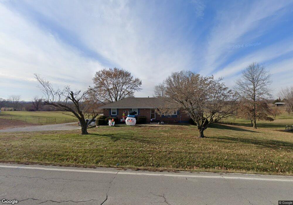
This home is located at 17510 State Route 33, Holt, MO 64048 and is currently estimated at $429,495, approximately $247 per square foot. 17510 State Route 33 is a home located in Clay County with nearby schools including Kearney Junior High School, Kearney High School, and Northern Hills Christian Academy.
Ownership History
Date
Name
Owned For
Owner Type
Purchase Details
Closed on
Jun 29, 1998
Sold by
Taff Dale and Taff Vera D
Bought by
Hoover Gerald Eugene and Hoover Janice Kay
Current Estimated Value
Home Financials for this Owner
Home Financials are based on the most recent Mortgage that was taken out on this home.
Original Mortgage
$70,000
Outstanding Balance
$13,705
Interest Rate
6.5%
Mortgage Type
Seller Take Back
Estimated Equity
$415,790
Create a Home Valuation Report for This Property
The Home Valuation Report is an in-depth analysis detailing your home's value as well as a comparison with similar homes in the area
Home Values in the Area
Average Home Value in this Area
Purchase History
| Date | Buyer | Sale Price | Title Company |
|---|---|---|---|
| Hoover Gerald Eugene | -- | -- | |
| Taff Richard Dale | -- | -- | |
| Harmon James K | -- | -- | |
| Harmon James K | -- | -- |
Source: Public Records
Mortgage History
| Date | Status | Borrower | Loan Amount |
|---|---|---|---|
| Open | Harmon James K | $70,000 |
Source: Public Records
Tax History
| Year | Tax Paid | Tax Assessment Tax Assessment Total Assessment is a certain percentage of the fair market value that is determined by local assessors to be the total taxable value of land and additions on the property. | Land | Improvement |
|---|---|---|---|---|
| 2025 | $2,603 | $47,290 | -- | -- |
| 2024 | $2,603 | $41,150 | -- | -- |
| 2023 | $2,594 | $41,150 | $0 | $0 |
| 2022 | $2,206 | $33,900 | $0 | $0 |
| 2021 | $2,159 | $33,896 | $5,225 | $28,671 |
| 2020 | $2,235 | $31,880 | $0 | $0 |
| 2019 | $2,222 | $31,880 | $0 | $0 |
Source: Public Records
Map
Nearby Homes
- 17504 State Route 33
- 16816 Landmark Loop
- 17102 Barr Ave
- Tract 2 Nation Rd
- 0 Lot 5 Arnold Park Lot N A Unit HMS2572371
- 0 Lot 3 Arnold Park Lot N A Unit HMS2572330
- 18208 Crestview Dr
- 15420 NE 162nd St
- Tbd Northeast 188th St
- 15016 NE 186th St
- TBD 188th Street N A
- 1200 W 10th Ave
- 102 W Lawrence St
- 911 Crestridge Dr
- 9900 NE 172nd St
- 803 Englewood Dr
- 706 Crestridge Dr
- 601 Crestridge Dr
- 972 W Innovation Dr
- 201 S Marimack Dr
- 17503 State Route 33
- 17522 State Route 33
- 17418 State Route 33
- 17415 State Route 33
- 17608 State Route 33
- 17215 NE 176th St
- 17402 State Route 33
- 17216 NE 176th St
- 17706 State Route 33
- 17602 NE 176th St
- 17323 Landmark Dr
- 17720 Missouri 33
- 17406 NE 176th St
- 17313 State Route 33
- 17315 State Route 33
- 17717 State Route 33
- 17705 Loop Rd
- 17720 State Route 33
- 17711 Loop Rd
- 17704 Thompson Rd
Your Personal Tour Guide
Ask me questions while you tour the home.