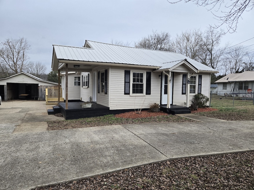
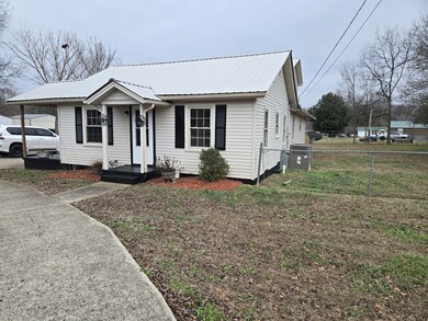
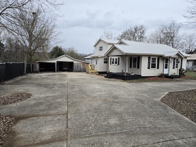
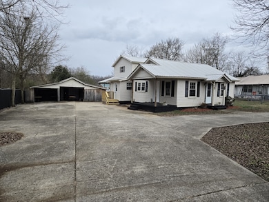
1755 W Trace Creek Rd Waverly, TN 37185
Estimated payment $1,356/month
Highlights
- Deck
- No HOA
- Eat-In Kitchen
- Separate Formal Living Room
- Covered Patio or Porch
- Walk-In Closet
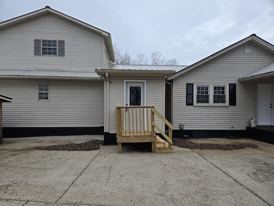
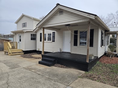
About This Home
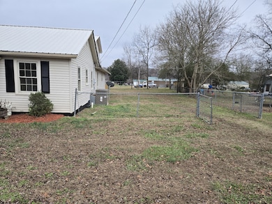
Nice 3/4 Bedroom Home with 3 Full Baths situated on a Level Lot. Renovated with up grades. Home has 3 BR but could have a 4th if your family needed. One Large Bedroom is upstairs with Large Closets and Full Bath. One Bedroom down Stairs has an extra 8x8 Room that would make a great sitting area or office. Large 16x24 Covered Deck on the back of the home along with a fenced side and back yard and concrete drive. Blacked-out privacy fence Nice home for the family. Contact Us for your showing.
Listing Agent
Neighborhood Realtors Brokerage Phone: 9312963131 License # 225679 Listed on: 12/02/2025
Home Details
Home Type
- Single Family
Est. Annual Taxes
- $549
Year Built
- Built in 1949
Lot Details
- 0.37 Acre Lot
- Lot Dimensions are 100x165
- Back Yard Fenced
- Level Lot
- Cleared Lot
Parking
- 2 Car Garage
Home Design
- Metal Roof
- Vinyl Siding
Interior Spaces
- 1,716 Sq Ft Home
- Property has 2 Levels
- Ceiling Fan
- Entrance Foyer
- Separate Formal Living Room
- Interior Storage Closet
- Washer and Electric Dryer Hookup
- Crawl Space
- Eat-In Kitchen
Flooring
- Carpet
- Laminate
Bedrooms and Bathrooms
- 4 Bedrooms | 3 Main Level Bedrooms
- Walk-In Closet
- 3 Full Bathrooms
Outdoor Features
- Deck
- Covered Patio or Porch
Schools
- Waverly Elementary School
- Waverly Jr High Middle School
- Waverly Central High School
Utilities
- Central Heating and Cooling System
Community Details
- No Home Owners Association
Listing and Financial Details
- Assessor Parcel Number 065 03200 000
Map
Home Values in the Area
Average Home Value in this Area
Tax History
| Year | Tax Paid | Tax Assessment Tax Assessment Total Assessment is a certain percentage of the fair market value that is determined by local assessors to be the total taxable value of land and additions on the property. | Land | Improvement |
|---|---|---|---|---|
| 2025 | $549 | $29,850 | $0 | $0 |
| 2024 | $549 | $29,850 | $1,250 | $28,600 |
| 2023 | $549 | $29,850 | $1,250 | $28,600 |
| 2022 | $476 | $21,850 | $2,275 | $19,575 |
| 2021 | $476 | $21,850 | $2,275 | $19,575 |
| 2020 | $476 | $21,850 | $2,275 | $19,575 |
| 2019 | $355 | $17,450 | $2,250 | $15,200 |
| 2018 | $355 | $17,450 | $2,250 | $15,200 |
| 2017 | $355 | $17,450 | $2,250 | $15,200 |
| 2016 | $338 | $15,350 | $2,250 | $13,100 |
| 2015 | $338 | $15,350 | $2,250 | $13,100 |
| 2014 | $337 | $15,339 | $0 | $0 |
Property History
| Date | Event | Price | List to Sale | Price per Sq Ft |
|---|---|---|---|---|
| 12/02/2025 12/02/25 | For Sale | $249,900 | -- | $146 / Sq Ft |
Purchase History
| Date | Type | Sale Price | Title Company |
|---|---|---|---|
| Deed | -- | -- | |
| Deed | $26,100 | -- | |
| Deed | $45,788 | -- | |
| Deed | $69,000 | -- | |
| Warranty Deed | $7,000 | -- | |
| Deed | -- | -- | |
| Deed | -- | -- | |
| Deed | -- | -- |
Source: Realtracs
MLS Number: 3056777
APN: 065-032.00
Disclaimer: Certain information contained herein is derived from information provided by parties other than Homes.com. All information provided is deemed reliable, but is not guaranteed to be accurate and should be independently verified.
![]() Based on information submitted to the MLS GRID. All data is obtained from various sources and may not have been verified by broker or MLS GRID. Supplied Open House Information is subject to change without notice. All information should be independently reviewed and verified for accuracy. Properties may or may not be listed by the office/agent presenting the information. Some IDX listings have been excluded from this website.
Based on information submitted to the MLS GRID. All data is obtained from various sources and may not have been verified by broker or MLS GRID. Supplied Open House Information is subject to change without notice. All information should be independently reviewed and verified for accuracy. Properties may or may not be listed by the office/agent presenting the information. Some IDX listings have been excluded from this website.
The Digital Millennium Copyright Act of 1998, 17 U.S.C. § 512 (the “DMCA”) provides recourse for copyright owners who believe that material appearing on the Internet infringes their rights under U.S. copyright law. If you believe in good faith that any content or material made available in connection with our website or services infringes your copyright, you (or your agent) may send us a notice requesting that the content or material be removed, or access to it blocked.
Notices must be sent in writing by email to DMCAnotice@MLSGrid.com.
The DMCA requires that your notice of alleged copyright infringement include the following information:
(1) description of the copyrighted work that is the subject of claimed infringement;
(2) description of the alleged infringing content and information sufficient to permit us to locate the content;
(3) contact information for you, including your address, telephone number and email address;
(4) a statement by you that you have a good faith belief that the content in the manner complained of is not authorized by the copyright owner, or its agent, or by the operation of any law;
(5) a statement by you, signed under penalty of perjury, that the information in the notification is accurate and that you have the authority to enforce the copyrights that are claimed to be infringed; and
(6) a physical or electronic signature of the copyright owner or a person authorized to act on the copyright owner’s behalf. Failure to include all of the above information may result in the delay of the processing of your complaint.
- 200 Brown Town Rd
- 106 Dupont Ave
- 1 Main St W
- 112 Sherwood Dr
- 107 W End Dr
- 113 Friel Dr
- 565 Landfill Rd
- 202 Bowen Heights Dr
- 437 W Main St
- 206 Collier Ave
- 152 Baker Ridge Rd
- 0 W Trace Creek Rd
- 2151 Bakerville Rd
- 381 Baker Ridge Rd
- 541 Clydeton Rd
- 1260 Clydeton Rd
- 221 Carroll Ave
- 191 Forks River Rd
- 1865 Clydeton Rd
- 314 N Maple Ave
- 204 S Clydeton Rd Unit E 1-8
- 80 Ridge Rd Unit D
- 80 Ridge Rd Unit C
- 80 Ridge Rd Unit A
- 80 Ridge Rd Unit B
- 0 Acorn Village Ln
- 542 Ashe Ave Unit 2
- 542 Ashe Ave Unit 7
- 218 Mike St
- 118 Stigall St
- 174 Schools Dr
- 200-202 3rd St Unit 200
- 732 Lucas Rd
- 301 Madison Ridge Blvd
- 1106 Redmon Cir
- 155 Covington Ln
- 212.5 W End Ave Unit A
- 174 Green Park Dr
- 150 Autumn Way
- 3845 Wickham Rd
