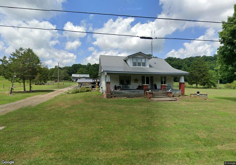
17559 State Route 41 West Union, OH 45693
Estimated Value: $223,000 - $333,835
3
Beds
1
Bath
1,728
Sq Ft
$153/Sq Ft
Est. Value
About This Home
This home is located at 17559 State Route 41, West Union, OH 45693 and is currently estimated at $263,945, approximately $152 per square foot. 17559 State Route 41 is a home located in Adams County with nearby schools including West Union Elementary School and West Union High School.
Ownership History
Date
Name
Owned For
Owner Type
Purchase Details
Closed on
Feb 26, 2024
Sold by
Mccann Kenneth R
Bought by
Mccann Kenneth R and Mccann Judith A
Current Estimated Value
Purchase Details
Closed on
May 14, 2003
Sold by
Mccann Charlotte R
Bought by
Mccann Charlotte R
Purchase Details
Closed on
Aug 27, 1998
Sold by
Dryden Ray S
Bought by
Mccann Charlotte R
Purchase Details
Closed on
Aug 26, 1998
Sold by
Mccann Charlotte R
Bought by
Mccann Charlotte R
Purchase Details
Closed on
Jan 1, 1990
Bought by
Dryden Ray S
Create a Home Valuation Report for This Property
The Home Valuation Report is an in-depth analysis detailing your home's value as well as a comparison with similar homes in the area
Home Values in the Area
Average Home Value in this Area
Purchase History
| Date | Buyer | Sale Price | Title Company |
|---|---|---|---|
| Mccann Kenneth R | -- | None Listed On Document | |
| Mccann Kenneth R | -- | None Listed On Document | |
| Mccann Charlotte R | -- | -- | |
| Mccann Charlotte R | $44,000 | -- | |
| Mccann Charlotte R | -- | -- | |
| Dryden Ray S | -- | -- |
Source: Public Records
Tax History Compared to Growth
Tax History
| Year | Tax Paid | Tax Assessment Tax Assessment Total Assessment is a certain percentage of the fair market value that is determined by local assessors to be the total taxable value of land and additions on the property. | Land | Improvement |
|---|---|---|---|---|
| 2024 | $447 | $79,030 | $60,830 | $18,200 |
| 2023 | $921 | $79,030 | $60,830 | $18,200 |
| 2022 | $928 | $62,760 | $47,290 | $15,470 |
| 2021 | $820 | $62,760 | $47,290 | $15,470 |
| 2020 | $838 | $62,760 | $47,290 | $15,470 |
| 2019 | $838 | $62,760 | $47,290 | $15,470 |
| 2018 | $933 | $54,570 | $41,130 | $13,440 |
| 2017 | $917 | $54,570 | $41,130 | $13,440 |
| 2016 | $458 | $54,570 | $41,130 | $13,440 |
| 2015 | $835 | $49,010 | $37,630 | $11,380 |
| 2014 | $836 | $49,010 | $37,630 | $11,380 |
Source: Public Records
Map
Nearby Homes
- 363 Crystal Rd
- 19004 State Route 41
- 292 Larry Baynum Rd
- 210 Walt Alsgood Rd
- 3460 Logans Ln
- 0 Paradise Valley Rd Unit 1852764
- 13465 State Route 41
- 108 Chirsdon Ln
- 668 Fawcett Rd
- 0 State Route 41 Unit 1830107
- 3551 Unity Rd
- 4016 Unity Rd
- 1011 Hafer Rd
- 1064 Hafer Rd
- 831 Tom Brown Rd
- 260 Randy St
- 216 Kurt St
- 1478 Robinson Hollow Rd
- 125 Robinette Rd
- 917 Logans Ln
- 17435 State Route 41
- 5 Cooper Rd
- 4 Cooper Rd
- 0 Cooper Rd
- 17253 State Route 41
- 380 Cooper Rd
- 393 Cooper Rd
- 17178 State Route 41
- 17145 State Route 41
- 1455 Crystal Rd
- 1261 Crystal Ln
- 1261 Crystal Rd
- 334 Crystal Rd
- 107 Crystal Rd
- 380 Cave Run Rd
- 107 Crystal Ln
- 0 Crystal Rd
- 595 Cooper Rd
- 1075 Cooper Rd
- A Cooper Rd