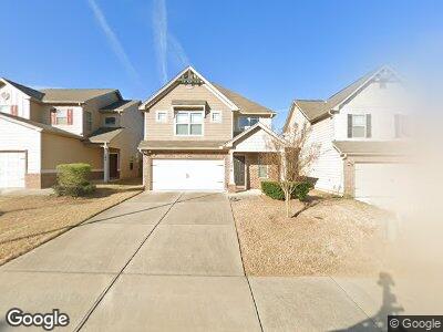
176 Leland Ln McDonough, GA 30253
Estimated Value: $310,191 - $327,000
3
Beds
3
Baths
1,920
Sq Ft
$166/Sq Ft
Est. Value
About This Home
This home is located at 176 Leland Ln, McDonough, GA 30253 and is currently estimated at $318,048, approximately $165 per square foot. 176 Leland Ln is a home located in Henry County with nearby schools including Walnut Creek Elementary School, Union Grove Middle School, and Union Grove High School.
Ownership History
Date
Name
Owned For
Owner Type
Purchase Details
Closed on
Apr 23, 2018
Sold by
Heritage Property Holdings
Bought by
Heritage Construction & Develo
Current Estimated Value
Purchase Details
Closed on
Jan 31, 2017
Sold by
Heritage Const & Dev Llc
Bought by
Monroe Kimberly
Home Financials for this Owner
Home Financials are based on the most recent Mortgage that was taken out on this home.
Original Mortgage
$166,920
Interest Rate
4.25%
Mortgage Type
FHA
Create a Home Valuation Report for This Property
The Home Valuation Report is an in-depth analysis detailing your home's value as well as a comparison with similar homes in the area
Home Values in the Area
Average Home Value in this Area
Purchase History
| Date | Buyer | Sale Price | Title Company |
|---|---|---|---|
| Heritage Construction & Develo | $132,000 | -- | |
| Monroe Kimberly | $170,000 | -- |
Source: Public Records
Mortgage History
| Date | Status | Borrower | Loan Amount |
|---|---|---|---|
| Open | Monroe Kimberly | $232,702 | |
| Closed | Monroe Kimberly | $12,230 | |
| Previous Owner | Monroe Kimberly | $166,920 |
Source: Public Records
Tax History Compared to Growth
Tax History
| Year | Tax Paid | Tax Assessment Tax Assessment Total Assessment is a certain percentage of the fair market value that is determined by local assessors to be the total taxable value of land and additions on the property. | Land | Improvement |
|---|---|---|---|---|
| 2024 | $3,985 | $131,760 | $20,000 | $111,760 |
| 2023 | $3,750 | $142,080 | $18,000 | $124,080 |
| 2022 | $3,337 | $103,960 | $16,000 | $87,960 |
| 2021 | $2,746 | $79,680 | $16,000 | $63,680 |
| 2020 | $2,684 | $76,880 | $16,000 | $60,880 |
| 2019 | $2,670 | $74,120 | $14,000 | $60,120 |
| 2018 | $2,486 | $68,000 | $13,600 | $54,400 |
| 2016 | $194 | $4,800 | $4,800 | $0 |
Source: Public Records
Map
Nearby Homes
- 0 Ivey Edwards Ln Unit 10409448
- 0 Ivey Edwards Ln Unit 10246400
- 705 Chase Ln
- 1051 Foxchase Dr
- 208 Rankin Cir
- 236 Rankin Cir
- 221 Huntington Dr
- 210 Huntington Dr
- 220 Cabriolet Trail
- 3081 Regal Dr
- 308 Rankin Cir
- 3041 Regal Dr
- 128 Brookhaven Ln
- 161 Cabriolet Trail
- 401 Cabriolet Ct
- 227 River Trace Ct
- 8240 Knollbrook Ln
- 2049 Town Square Dr
- 500 Katherines Cove
- 740 Azalea Ave
- 176 Leland Ln Unit 20
- 176 Leland Ln
- 180 Leland Ln Unit 21
- 180 Leland Ln
- 172 Leland Ln Unit 19
- 172 Leland Ln
- 172 Leland Ln
- 172 Leland Ln Unit 19
- 172 Leland Ln
- 184 Leland Ln Unit 22
- 168 Leland Ln Unit 18
- 188 Leland Ln Unit 23
- 188 Leland Ln Unit 43
- 188 Leland Ln
- 164 Leland Ln Unit 17
- 160 Leland Ln Unit 16
- 160 Leland Ln
- 192 Leland Ln
- 192 Leland Ln Unit 24
- 175 Leland Ln Unit 40