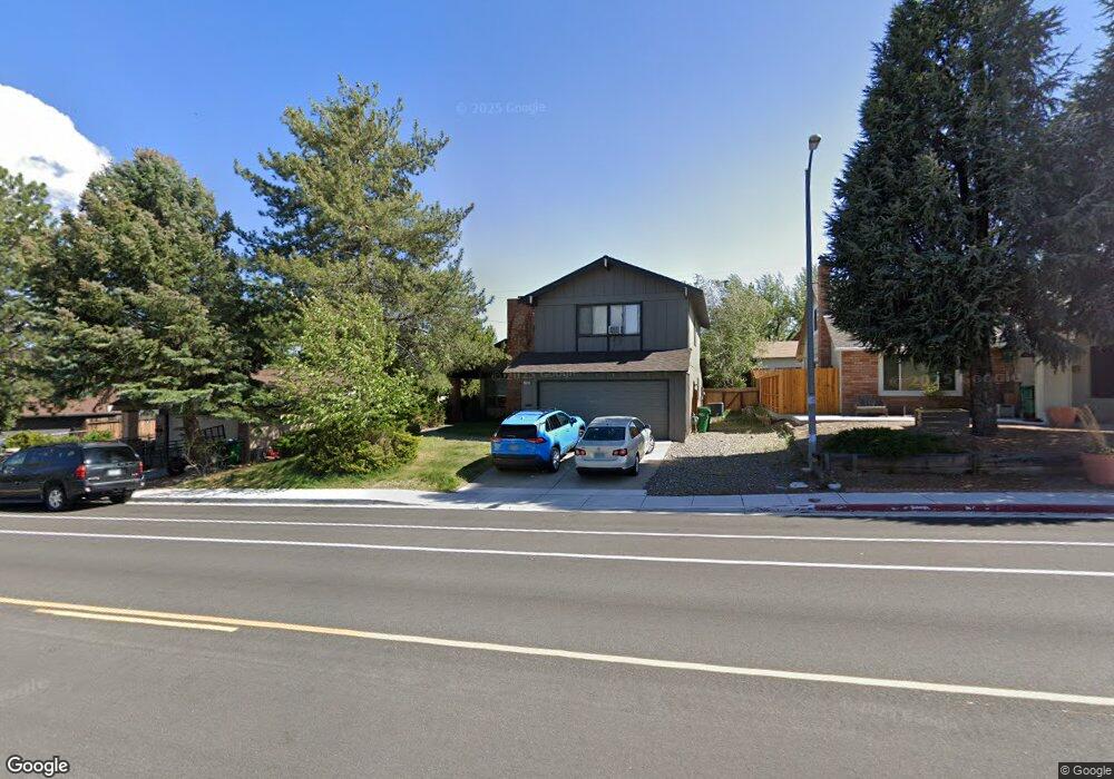
1760 Kings Row Reno, NV 89503
Kings Row NeighborhoodEstimated Value: $503,578 - $555,000
4
Beds
3
Baths
1,986
Sq Ft
$265/Sq Ft
Est. Value
About This Home
This home is located at 1760 Kings Row, Reno, NV 89503 and is currently estimated at $527,145, approximately $265 per square foot. 1760 Kings Row is a home located in Washoe County with nearby schools including Elmcrest Elementary School, Archie Clayton Pre-AP Academy, and Robert McQueen High School.
Ownership History
Date
Name
Owned For
Owner Type
Purchase Details
Closed on
Jul 10, 2020
Sold by
Fune Dawn and Hill Dawn Marie
Bought by
Fune Todd and Fune Dawn
Current Estimated Value
Home Financials for this Owner
Home Financials are based on the most recent Mortgage that was taken out on this home.
Original Mortgage
$234,500
Outstanding Balance
$207,939
Interest Rate
3.1%
Mortgage Type
New Conventional
Estimated Equity
$319,206
Purchase Details
Closed on
Oct 10, 2002
Sold by
Hill Dawn M
Bought by
Timko Elsie J
Create a Home Valuation Report for This Property
The Home Valuation Report is an in-depth analysis detailing your home's value as well as a comparison with similar homes in the area
Home Values in the Area
Average Home Value in this Area
Purchase History
| Date | Buyer | Sale Price | Title Company |
|---|---|---|---|
| Fune Todd | -- | Ticor Title Reno | |
| Timko Elsie J | $39,000 | -- |
Source: Public Records
Mortgage History
| Date | Status | Borrower | Loan Amount |
|---|---|---|---|
| Open | Fune Todd | $234,500 |
Source: Public Records
Tax History Compared to Growth
Tax History
| Year | Tax Paid | Tax Assessment Tax Assessment Total Assessment is a certain percentage of the fair market value that is determined by local assessors to be the total taxable value of land and additions on the property. | Land | Improvement |
|---|---|---|---|---|
| 2025 | $1,757 | $63,769 | $35,816 | $27,953 |
| 2024 | $1,757 | $61,283 | $33,737 | $27,546 |
| 2023 | $1,127 | $62,349 | $35,280 | $27,069 |
| 2022 | $1,509 | $51,672 | $28,350 | $23,322 |
| 2021 | $1,466 | $43,058 | $19,121 | $23,937 |
| 2020 | $1,422 | $43,066 | $17,987 | $25,079 |
| 2019 | $2,313 | $43,127 | $18,270 | $24,857 |
| 2018 | $2,320 | $37,933 | $13,010 | $24,923 |
| 2017 | $2,282 | $37,820 | $12,269 | $25,551 |
| 2016 | $2,110 | $37,399 | $10,773 | $26,626 |
| 2015 | $2,109 | $36,304 | $9,144 | $27,160 |
| 2014 | $2,102 | $34,726 | $8,146 | $26,580 |
| 2013 | -- | $32,459 | $5,819 | $26,640 |
Source: Public Records
Map
Nearby Homes
- 1540 King Edward Dr
- 1855 Prince Way
- 1670 Majestic Dr
- 1765 Harold Dr
- 1845 Wesley Dr
- 1600 Majestic Dr
- 1375 Wesley Dr
- 1510 Majestic Dr Unit one
- 1415 Kings Row
- 895 Stoker Ave
- 1702 Grandview Ave
- 880 Ruby Ave
- 2120 Keystone Ave
- 1480 Grandview Ave
- 1217 Keystone Ave
- 1535 Van Ness Ave
- 840 Brookfield Dr
- 2718 Powder Dr
- 1801 Carlin St
- 1970 W 6th St
- 1780 Kings Row
- 1740 Kings Row
- 1835 Prince Way
- 1800 Kings Row
- 1720 Kings Row
- 1815 Prince Way
- 1765 Kings Row
- 1895 Prince Way
- 1785 Kings Row
- 1820 Kings Row
- 1795 Kings Row
- 1145 McDonald Dr
- 1055 McDonald Dr
- 1195 McDonald Dr
- 1400 Severn Dr
- 1815 Kings Row
- 1840 Prince Way
- 1915 Prince Way
- 1915 Prince Way Unit Way
- 1800 Prior Rd