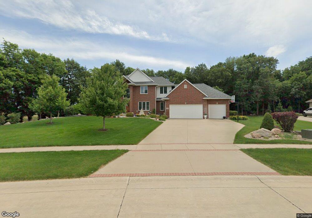
1760 Maple St Robins, IA 52328
Estimated Value: $536,000 - $839,000
5
Beds
5
Baths
5,010
Sq Ft
$143/Sq Ft
Est. Value
About This Home
This home is located at 1760 Maple St, Robins, IA 52328 and is currently estimated at $715,156, approximately $142 per square foot. 1760 Maple St is a home located in Linn County with nearby schools including Echo Hill Elementary School, Oak Ridge School, and Linn-Mar High School.
Ownership History
Date
Name
Owned For
Owner Type
Purchase Details
Closed on
Jan 13, 2010
Sold by
Koopmann Tim and Koopmann Michelle
Bought by
Trachta Dennis W and Trachta Connie A
Current Estimated Value
Home Financials for this Owner
Home Financials are based on the most recent Mortgage that was taken out on this home.
Original Mortgage
$417,000
Interest Rate
4.87%
Mortgage Type
New Conventional
Purchase Details
Closed on
Jan 3, 2002
Sold by
R J Development Llc
Bought by
Koopmann Tim and Koopmann Michelle
Create a Home Valuation Report for This Property
The Home Valuation Report is an in-depth analysis detailing your home's value as well as a comparison with similar homes in the area
Home Values in the Area
Average Home Value in this Area
Purchase History
| Date | Buyer | Sale Price | Title Company |
|---|---|---|---|
| Trachta Dennis W | $586,500 | None Available | |
| Koopmann Tim | $65,000 | -- |
Source: Public Records
Mortgage History
| Date | Status | Borrower | Loan Amount |
|---|---|---|---|
| Closed | Trachta Dennis W | $417,000 |
Source: Public Records
Tax History
| Year | Tax Paid | Tax Assessment Tax Assessment Total Assessment is a certain percentage of the fair market value that is determined by local assessors to be the total taxable value of land and additions on the property. | Land | Improvement |
|---|---|---|---|---|
| 2025 | $11,628 | $755,100 | $109,700 | $645,400 |
| 2024 | $9,512 | $772,900 | $109,700 | $663,200 |
| 2023 | $9,512 | $772,900 | $109,700 | $663,200 |
| 2022 | $9,872 | $568,300 | $109,700 | $458,600 |
| 2021 | $11,234 | $568,300 | $109,700 | $458,600 |
| 2020 | $11,234 | $602,700 | $109,700 | $493,000 |
| 2019 | $10,910 | $587,200 | $109,700 | $477,500 |
| 2018 | $10,518 | $587,200 | $109,700 | $477,500 |
| 2017 | $10,572 | $578,100 | $109,700 | $468,400 |
| 2016 | $10,572 | $577,000 | $109,700 | $467,300 |
| 2015 | $10,602 | $577,000 | $109,700 | $467,300 |
| 2014 | $10,442 | $577,000 | $109,700 | $467,300 |
| 2013 | $10,060 | $577,000 | $109,700 | $467,300 |
Source: Public Records
Map
Nearby Homes
- 0 Maple St
- 9124 Grand Oaks Dr NE
- 5466 Silver Ridge Rd
- 8932 Norway Dr NE
- 8926 Norway Dr NE
- 804 Palmyra Dr NE
- 207 Meadows Field Dr NE
- 165 Timber Ln
- 222 Mccarran Ave NE
- 226 Mccarran Ave NE
- 8806 Zeppelin Ave
- 1399 Echo Ridge Ln
- 219 Mccarran Ave NE
- 8800 Zeppelin Ave
- 5321 Silver Rock Dr
- 8608 Flatbush Ct NE
- 5557 Silver Rock Dr
- 233 Mccarran Ave NE
- 218 Mccarran Ave NE
- 1359 Cedar Springs Dr
Your Personal Tour Guide
Ask me questions while you tour the home.