
Seller's Agent in 2025
Mary Reilly
Windermere RE Lane County
(541) 484-2022
3 in this area
56 Total Sales
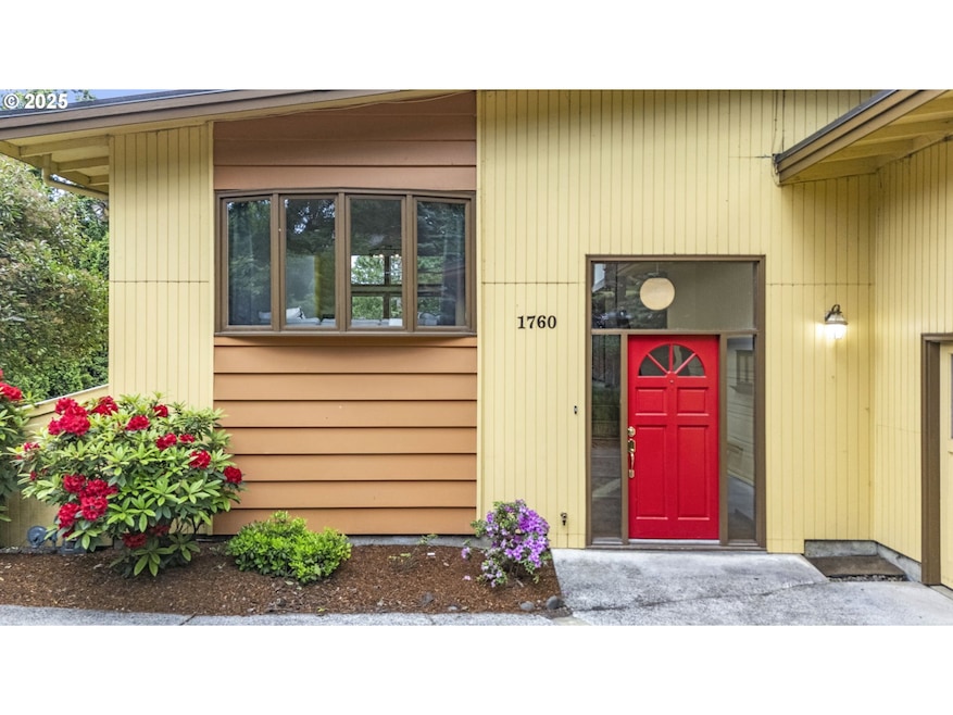

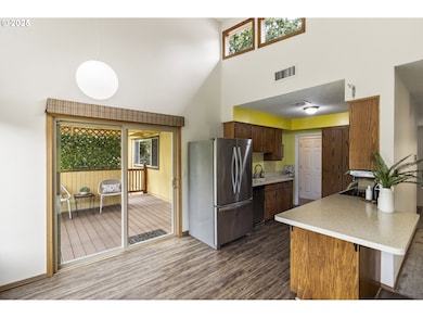
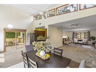
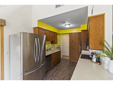
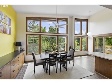
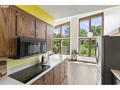
This mid-century modern split-level home seamlessly blends classic design with modern convenience. Featuring four bedrooms and two baths, it offers a spacious and functional layout. Upstairs, large windows with motorized blinds (installed in 2023) fill the space with natural light, showcasing stunning views of Blanton Heights. The dining room includes a built-in buffet, complemented by newly installed luxury vinyl plank flooring in the dining and kitchen areas for both style and durability. A patio off the kitchen provides a private space for morning coffee or casual meals. Downstairs, a spacious second living room creates a cozy retreat, complete with a gas fireplace for added warmth and ambiance. This inviting space leads directly to a backyard patio, perfect for outdoor entertainment or quiet relaxation. A hot tub enhances the backyard’s appeal, surrounded by beautiful landscaping on a low-traffic, dead-end street. Underground utilities not only enhance the visual appeal of the neighborhood but also reduce the risk of power outages.
Last Agent to Sell the Property
Windermere RE Lane County Brokerage Phone: 541-912-4140 License #201236146 Listed on: 05/30/2025
| Date | Type | Sale Price | Title Company |
|---|---|---|---|
| Warranty Deed | $543,500 | Western Title | |
| Warranty Deed | $275,000 | Western Title & Escrow | |
| Warranty Deed | $190,000 | Western Pioneer Title Co |
| Date | Status | Loan Amount | Loan Type |
|---|---|---|---|
| Open | $516,325 | New Conventional | |
| Previous Owner | $220,000 | New Conventional | |
| Previous Owner | $174,591 | No Value Available |
| Date | Event | Price | List to Sale | Price per Sq Ft |
|---|---|---|---|---|
| 08/15/2025 08/15/25 | Sold | $534,500 | -2.8% | $233 / Sq Ft |
| 07/24/2025 07/24/25 | Pending | -- | -- | -- |
| 07/07/2025 07/07/25 | Price Changed | $550,000 | -3.5% | $240 / Sq Ft |
| 06/23/2025 06/23/25 | Price Changed | $570,000 | -1.7% | $249 / Sq Ft |
| 05/30/2025 05/30/25 | For Sale | $580,000 | -- | $253 / Sq Ft |
| Year | Tax Paid | Tax Assessment Tax Assessment Total Assessment is a certain percentage of the fair market value that is determined by local assessors to be the total taxable value of land and additions on the property. | Land | Improvement |
|---|---|---|---|---|
| 2025 | $6,752 | $346,548 | -- | -- |
| 2024 | $6,668 | $336,455 | -- | -- |
| 2023 | $6,668 | $326,656 | -- | -- |
| 2022 | $6,247 | $317,142 | $0 | $0 |
| 2021 | $5,867 | $307,905 | $0 | $0 |
| 2020 | $5,888 | $298,937 | $0 | $0 |
| 2019 | $5,640 | $290,231 | $0 | $0 |
| 2018 | $5,264 | $273,571 | $0 | $0 |
| 2017 | $4,936 | $273,571 | $0 | $0 |
| 2016 | $4,788 | $265,603 | $0 | $0 |
| 2015 | $4,632 | $257,867 | $0 | $0 |
| 2014 | $4,530 | $250,356 | $0 | $0 |
Seller's Agent in 2025
Mary Reilly
Windermere RE Lane County
(541) 484-2022
3 in this area
56 Total Sales
Buyer's Agent in 2025
Hannah Clotere
ICON Real Estate Group
(541) 543-9345
6 in this area
64 Total Sales
Source: Regional Multiple Listing Service (RMLS)
MLS Number: 617904882
APN: 0729598
Disclaimer: Certain information contained herein is derived from information provided by parties other than Homes.com. All information provided is deemed reliable, but is not guaranteed to be accurate and should be independently verified.
![]() The content relating to real estate for sale on this web site comes in part from the IDX program of the RMLS™ of Portland, Oregon. Real estate listings held by brokerage firms other than Ten-X are marked with the RMLS™ logo, and detailed information about these properties includes the names of the listing brokers. Listing content is copyright © 2026 RMLS™, Portland, Oregon. Some properties which appear for sale on this web site may subsequently have sold or may no longer be available. All information provided is deemed reliable but is not guaranteed and should be independently verified.
The content relating to real estate for sale on this web site comes in part from the IDX program of the RMLS™ of Portland, Oregon. Real estate listings held by brokerage firms other than Ten-X are marked with the RMLS™ logo, and detailed information about these properties includes the names of the listing brokers. Listing content is copyright © 2026 RMLS™, Portland, Oregon. Some properties which appear for sale on this web site may subsequently have sold or may no longer be available. All information provided is deemed reliable but is not guaranteed and should be independently verified.
Ask me questions while you tour the home.