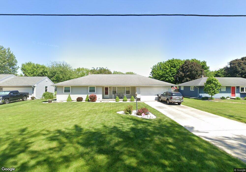
1763 Buchanan Rd Fremont, OH 43420
Estimated Value: $213,000 - $253,000
3
Beds
3
Baths
1,778
Sq Ft
$134/Sq Ft
Est. Value
About This Home
This home is located at 1763 Buchanan Rd, Fremont, OH 43420 and is currently estimated at $238,551, approximately $134 per square foot. 1763 Buchanan Rd is a home located in Sandusky County with nearby schools including Fremont Ross High School, Sacred Heart School, and Bishop Hoffman Catholic School - This is St Joe's School now.
Ownership History
Date
Name
Owned For
Owner Type
Purchase Details
Closed on
Mar 18, 2017
Sold by
Nye Robert J
Bought by
Nye Robert J and Grundy Laressa R
Current Estimated Value
Purchase Details
Closed on
Feb 1, 2011
Sold by
Huber Kristie L
Bought by
Nye Robert J
Home Financials for this Owner
Home Financials are based on the most recent Mortgage that was taken out on this home.
Original Mortgage
$117,616
Outstanding Balance
$80,711
Interest Rate
4.84%
Mortgage Type
FHA
Estimated Equity
$157,840
Purchase Details
Closed on
May 16, 2007
Sold by
Decker Florence M
Bought by
Decker Florence M and Florence M Decker Living Trust
Create a Home Valuation Report for This Property
The Home Valuation Report is an in-depth analysis detailing your home's value as well as a comparison with similar homes in the area
Home Values in the Area
Average Home Value in this Area
Purchase History
| Date | Buyer | Sale Price | Title Company |
|---|---|---|---|
| Nye Robert J | -- | Attorney | |
| Nye Robert J | $118,500 | First American Title | |
| Decker Florence M | -- | Attorney |
Source: Public Records
Mortgage History
| Date | Status | Borrower | Loan Amount |
|---|---|---|---|
| Open | Nye Robert J | $117,616 |
Source: Public Records
Tax History Compared to Growth
Tax History
| Year | Tax Paid | Tax Assessment Tax Assessment Total Assessment is a certain percentage of the fair market value that is determined by local assessors to be the total taxable value of land and additions on the property. | Land | Improvement |
|---|---|---|---|---|
| 2024 | $2,491 | $63,880 | $10,500 | $53,380 |
| 2023 | $2,491 | $53,240 | $8,750 | $44,490 |
| 2022 | $2,218 | $53,240 | $8,750 | $44,490 |
| 2021 | $2,285 | $53,240 | $8,750 | $44,490 |
| 2020 | $2,068 | $47,180 | $8,750 | $38,430 |
| 2019 | $2,066 | $47,180 | $8,750 | $38,430 |
| 2018 | $1,846 | $47,180 | $8,750 | $38,430 |
| 2017 | $1,681 | $39,200 | $8,750 | $30,450 |
| 2016 | $1,473 | $39,200 | $8,750 | $30,450 |
| 2015 | $1,449 | $39,200 | $8,750 | $30,450 |
| 2014 | $1,465 | $37,980 | $8,580 | $29,400 |
| 2013 | $1,433 | $37,980 | $8,580 | $29,400 |
Source: Public Records
Map
Nearby Homes
- 933 E Cole Rd
- 18 Katlyn Dr
- 1826 Morrison Rd
- 1832 Myrtle St
- 1970 Morrison Rd
- 1818 Finley Dr
- 135 Briarwood Cir
- 350 Conner Dr
- 41 Brookview Dr
- 600 S Buchanan St
- 64 River Run Dr Unit J
- 64 River Run Dr
- 0 S Buchanan St
- 546 Oaklawn Ave
- 800 Lawndale Dr
- 10 Meadowbrook Ln
- 10 Meadowbrook Dr
- 906 Amsden Blvd
- 905 Twinn St
- 1013 Whittlesey St
- 1763 S Buchanan St
- 1771 S Buchanan St
- 1757 S Buchanan St
- 1777 S Buchanan St
- 1751 S Buchanan St
- 1762 S Buchanan St
- 1770 Oak Dr
- 1762 Oak Dr
- 1772 S Buchanan St
- 1043 Richard Dr
- 1721 S Buchanan St
- 1752 Oak Dr
- 1776 Oak Dr
- 1720 Oak Dr
- 1807 S Buchanan Rd
- 1715 Buchanan Rd
- 1715 S Buchanan St
- 1044 Richard Dr
- 1115 E Cole Rd
- 1033 Richard Dr