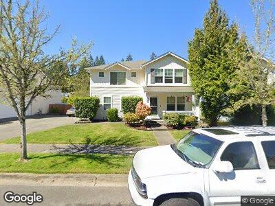
1763 Burnside Ave Dupont, WA 98327
Estimated Value: $620,202 - $650,000
3
Beds
3
Baths
2,425
Sq Ft
$262/Sq Ft
Est. Value
About This Home
This home is located at 1763 Burnside Ave, Dupont, WA 98327 and is currently estimated at $635,301, approximately $261 per square foot. 1763 Burnside Ave is a home located in Pierce County with nearby schools including Chloe Clark Elementary School, Saltars Point Elementary School, and Pioneer Middle School.
Ownership History
Date
Name
Owned For
Owner Type
Purchase Details
Closed on
Apr 30, 2008
Sold by
Davis Earl D and Davis Cynthia C
Bought by
Drca Nenad and Drca Anna
Current Estimated Value
Home Financials for this Owner
Home Financials are based on the most recent Mortgage that was taken out on this home.
Original Mortgage
$310,000
Interest Rate
5.81%
Mortgage Type
VA
Purchase Details
Closed on
Dec 16, 2002
Sold by
The Quadrant Corp
Bought by
Davis Earl D and Davis Cynthia C
Home Financials for this Owner
Home Financials are based on the most recent Mortgage that was taken out on this home.
Original Mortgage
$125,000
Interest Rate
6.03%
Create a Home Valuation Report for This Property
The Home Valuation Report is an in-depth analysis detailing your home's value as well as a comparison with similar homes in the area
Home Values in the Area
Average Home Value in this Area
Purchase History
| Date | Buyer | Sale Price | Title Company |
|---|---|---|---|
| Drca Nenad | $310,000 | Fidelity National Title Insu | |
| Davis Earl D | $219,911 | Chicago Title |
Source: Public Records
Mortgage History
| Date | Status | Borrower | Loan Amount |
|---|---|---|---|
| Open | Drca Nenad | $306,000 | |
| Closed | Drca Nenad | $310,000 | |
| Previous Owner | Davis Earl D | $150,000 | |
| Previous Owner | Davis Earl D | $30,000 | |
| Previous Owner | Davis Earl D | $125,000 |
Source: Public Records
Tax History Compared to Growth
Tax History
| Year | Tax Paid | Tax Assessment Tax Assessment Total Assessment is a certain percentage of the fair market value that is determined by local assessors to be the total taxable value of land and additions on the property. | Land | Improvement |
|---|---|---|---|---|
| 2024 | $4,152 | $540,400 | $221,500 | $318,900 |
| 2023 | $4,152 | $516,000 | $213,600 | $302,400 |
| 2022 | $4,131 | $525,200 | $213,600 | $311,600 |
| 2021 | $3,924 | $389,800 | $135,700 | $254,100 |
| 2019 | $3,510 | $354,900 | $113,100 | $241,800 |
| 2018 | $3,766 | $343,300 | $113,100 | $230,200 |
| 2017 | $3,381 | $322,700 | $98,300 | $224,400 |
| 2016 | $3,227 | $291,900 | $82,900 | $209,000 |
| 2014 | $3,121 | $286,700 | $82,900 | $203,800 |
| 2013 | $3,121 | $262,000 | $84,600 | $177,400 |
Source: Public Records
Map
Nearby Homes
- 1860 Hoffman Hill Blvd
- 2898 Cox St
- 3163 Walker Rd
- 3097 Obrien St
- 1662 Jensen Ave
- 3084 Sheaser Way
- 3079 Sheaser Way
- 1375 Foreman Rd
- 2758 Mcneil St
- 2048 Jensen Ave
- 1344 Foreman Rd
- 2402 Meyer St
- 3234 Hoffman Hill Blvd
- 1335 Foreman Rd
- 1190 Swan Loop
- 1194 Swan Loop
- 1306 Brackenridge Ave
- 3412 Hoffman Hill Blvd
- 1061 Hiton Cir
- 1077 Hiton Cir
- 1763 Burnside Ave
- 1775 Burnside Ave
- 1759 Burnside Ave
- 1799 Burnside Ave
- 1747 Burnside Ave
- 1762 Burnside Ave
- 1774 Burnside Ave
- 1758 Burnside Ave
- 1755 Hoffman Hill Blvd
- 1735 Burnside Ave
- 1763 Hoffman Hill Blvd
- 1749 Hoffman Hill Blvd
- 1777 Hoffman Hill Blvd
- 1744 Burnside Ave
- 1733 Hoffman Hill Blvd
- 1798 Burnside Ave
- 1781 Hoffman Hill Blvd
- 1800 Hoffman Hill Blvd
- 1721 Burnside Ave
- 1736 Burnside Ave