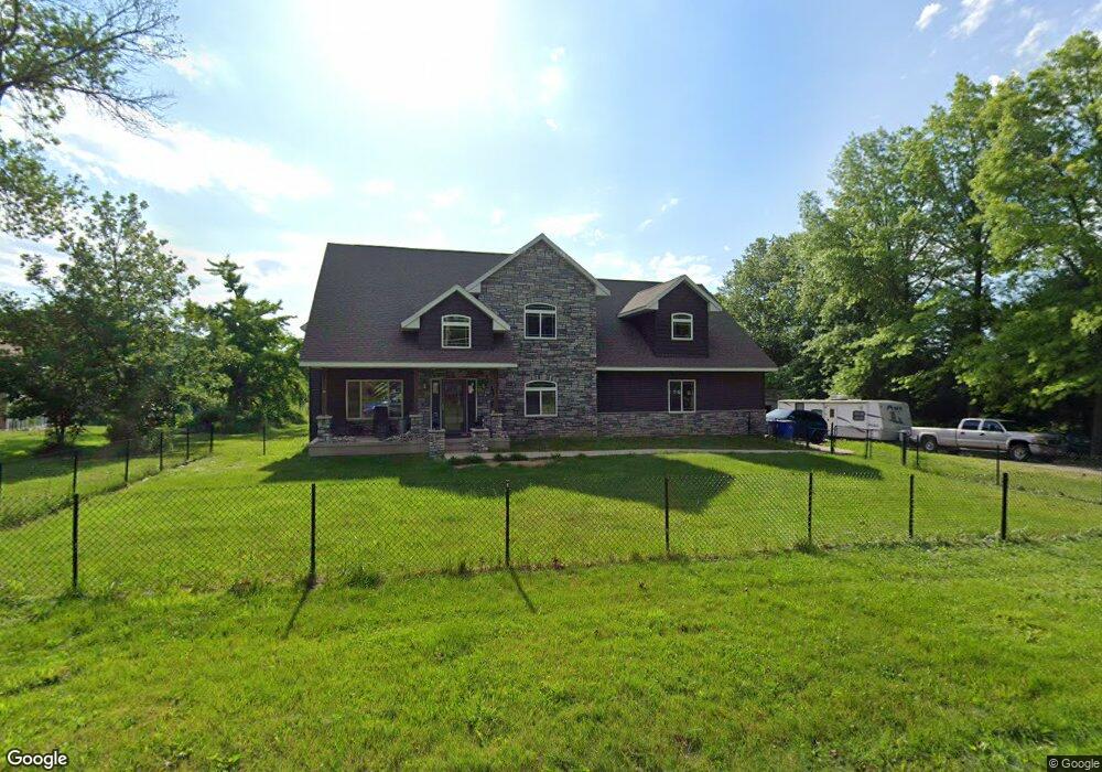
1764 34th St SE Cedar Rapids, IA 52403
Estimated Value: $391,000 - $659,076
3
Beds
3
Baths
4,812
Sq Ft
$103/Sq Ft
Est. Value
About This Home
This home is located at 1764 34th St SE, Cedar Rapids, IA 52403 and is currently estimated at $497,359, approximately $103 per square foot. 1764 34th St SE is a home located in Linn County with nearby schools including Erskine Elementary School, McKinley STEAM Academy, and George Washington High School.
Ownership History
Date
Name
Owned For
Owner Type
Purchase Details
Closed on
Dec 19, 2014
Sold by
Jones Bonnie M and Jones Douglas
Bought by
Lane Robert E
Current Estimated Value
Home Financials for this Owner
Home Financials are based on the most recent Mortgage that was taken out on this home.
Original Mortgage
$85,000
Outstanding Balance
$65,893
Interest Rate
4.25%
Mortgage Type
Adjustable Rate Mortgage/ARM
Estimated Equity
$431,466
Purchase Details
Closed on
Sep 4, 2012
Sold by
Jones Bonnie M and Mcdonough Bonnie M
Bought by
Jones Bonnie M
Purchase Details
Closed on
Jun 4, 2001
Sold by
Lee Mark Kenneth Michael and Lee Mark Susan
Bought by
Jones Douglas F
Purchase Details
Closed on
Aug 19, 1998
Sold by
Barnett Steve and Barnett Lori L
Bought by
Jones D F and Mcdonough Bonnie
Purchase Details
Closed on
Apr 15, 1998
Sold by
Matthiessen Darin J and Matthiessen Jennifer J
Bought by
Jones Douglas F and Mcdonough Bonnie M
Create a Home Valuation Report for This Property
The Home Valuation Report is an in-depth analysis detailing your home's value as well as a comparison with similar homes in the area
Home Values in the Area
Average Home Value in this Area
Purchase History
| Date | Buyer | Sale Price | Title Company |
|---|---|---|---|
| Lane Robert E | $100,000 | None Available | |
| Jones Bonnie M | -- | None Available | |
| Jones Douglas F | $33,500 | -- | |
| Jones D F | -- | -- | |
| Jones Douglas F | $20,500 | -- |
Source: Public Records
Mortgage History
| Date | Status | Borrower | Loan Amount |
|---|---|---|---|
| Open | Lane Robert E | $85,000 |
Source: Public Records
Tax History Compared to Growth
Tax History
| Year | Tax Paid | Tax Assessment Tax Assessment Total Assessment is a certain percentage of the fair market value that is determined by local assessors to be the total taxable value of land and additions on the property. | Land | Improvement |
|---|---|---|---|---|
| 2025 | $9,186 | $593,200 | $83,500 | $509,700 |
| 2024 | $11,166 | $590,400 | $83,600 | $506,800 |
| 2023 | $11,166 | $546,100 | $80,300 | $465,800 |
| 2022 | $10,162 | $554,900 | $69,700 | $485,200 |
| 2021 | $10,394 | $499,500 | $57,300 | $442,200 |
| 2020 | $10,394 | $479,700 | $41,500 | $438,200 |
| 2019 | $8,332 | $395,100 | $41,500 | $353,600 |
| 2018 | $2,680 | $395,100 | $41,500 | $353,600 |
| 2017 | $2,984 | $56,000 | $41,500 | $14,500 |
| 2016 | $2,984 | $140,400 | $41,500 | $98,900 |
| 2015 | $2,831 | $133,086 | $41,525 | $91,561 |
| 2014 | $2,646 | $133,086 | $41,525 | $91,561 |
| 2013 | $2,586 | $133,086 | $41,525 | $91,561 |
Source: Public Records
Map
Nearby Homes
- 3509 Pioneer Ave SE
- 3535 Pioneer Ave SE
- 1635 31st St SE
- 1521 Oak Ridge Ln SE Unit 3
- 1401 Harold Dr SE
- 1331 34th St SE
- 1416 38th St SE
- 1325 36th St SE
- 1333 Harold Dr SE
- 2861 Seely Ave SE
- 1241 38th St SE
- 4121 Windham Woods Ct SE
- 1111 Brockman Dr SE
- Tbd 42nd St SE
- 1310 42nd St SE
- 1310 42nd St SE Unit LotWP001
- 1649 Memorial Dr SE
- Tbd 42nd St SE
- 1013 36th St SE
- 1524 Memorial Dr SE
- 1750 34th St SE
- 1740 34th St SE
- 3210 Wood Ave SE
- 1720 34th St SE
- 3204 Wood Ave SE
- 3200 Wood Ave SE
- 1755 34th St SE
- 1735 34th St SE
- 1640 34th St SE
- 1651 34th St SE Unit 25
- 1651 34th St SE Unit 24
- 1651 34th St SE Unit 23
- 1651 34th St SE Unit 22
- 1651 34th St SE Unit 21
- 1651 34th St SE Unit 20
- 1651 34th St SE Unit 19
- 1651 34th St SE Unit 18
- 1651 34th St SE Unit 17
- 1651 34th St SE Unit 16
- 1651 34th St SE Unit 15