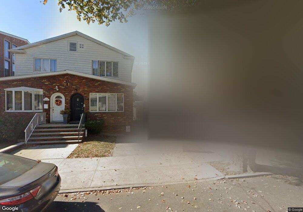
1764 E 2nd St Brooklyn, NY 11223
Gravesend NeighborhoodEstimated Value: $864,303 - $2,313,000
Studio
--
Bath
1,184
Sq Ft
$1,536/Sq Ft
Est. Value
About This Home
This home is located at 1764 E 2nd St, Brooklyn, NY 11223 and is currently estimated at $1,818,826, approximately $1,536 per square foot. 1764 E 2nd St is a home located in Kings County with nearby schools including P.S. 215 Morris H Weiss, Is 228 David A Boody, and James Madison High School.
Ownership History
Date
Name
Owned For
Owner Type
Purchase Details
Closed on
Oct 21, 2021
Sold by
Betesh Abraham and Betesh Fortune
Bought by
Af Brooklyn Llc
Current Estimated Value
Purchase Details
Closed on
Oct 10, 2000
Sold by
Levy Moshe
Bought by
Betesh Abraham and Betesh Fortune
Home Financials for this Owner
Home Financials are based on the most recent Mortgage that was taken out on this home.
Original Mortgage
$300,000
Interest Rate
7.78%
Purchase Details
Closed on
Oct 27, 1997
Sold by
Martin Andrew
Bought by
Levy Moshe and Levy Isaac
Home Financials for this Owner
Home Financials are based on the most recent Mortgage that was taken out on this home.
Original Mortgage
$138,750
Interest Rate
7.87%
Create a Home Valuation Report for This Property
The Home Valuation Report is an in-depth analysis detailing your home's value as well as a comparison with similar homes in the area
Home Values in the Area
Average Home Value in this Area
Purchase History
| Date | Buyer | Sale Price | Title Company |
|---|---|---|---|
| Af Brooklyn Llc | -- | -- | |
| Betesh Abraham | $350,000 | Commonwealth Land Title Ins | |
| Levy Moshe | -- | First American Title Ins Co |
Source: Public Records
Mortgage History
| Date | Status | Borrower | Loan Amount |
|---|---|---|---|
| Previous Owner | Betesh Abraham | $300,000 | |
| Previous Owner | Levy Moshe | $138,750 |
Source: Public Records
Tax History
| Year | Tax Paid | Tax Assessment Tax Assessment Total Assessment is a certain percentage of the fair market value that is determined by local assessors to be the total taxable value of land and additions on the property. | Land | Improvement |
|---|---|---|---|---|
| 2025 | $2,620 | $29,580 | $29,580 | -- |
| 2024 | $2,620 | $28,440 | $28,440 | $0 |
| 2023 | $2,558 | $26,100 | $26,100 | $0 |
| 2022 | $2,245 | $27,180 | $27,180 | $0 |
| 2021 | $2,467 | $23,640 | $23,640 | $0 |
| 2019 | $2,274 | $17,880 | $17,880 | $0 |
| 2018 | $2,139 | $10,494 | $10,494 | $0 |
| 2017 | $2,018 | $9,900 | $9,900 | $0 |
| 2016 | $1,955 | $9,780 | $9,780 | $0 |
| 2015 | $1,311 | $9,603 | $9,603 | $0 |
| 2014 | $1,311 | $9,060 | $9,060 | $0 |
Source: Public Records
Map
Nearby Homes
- 1815 E 3rd St
- 1736 E 2nd St
- 1899 E 3rd St
- 15 Van Sicklen St
- 1730 E 4th St
- 1726 E 4th St
- 1733 E 4th St Unit 1A
- 380 Avenue P
- 1806 McDonald Ave
- 1684 W 2nd St
- 1800 Ocean Pkwy Unit E11
- 411 Avenue P
- 33 Kings Place
- 447 Avenue P Unit 407
- 1802 Ocean Pkwy Unit C9
- 393 Avenue S Unit 5H
- 393 Avenue S Unit 5D
- 393 Avenue S Unit 3G
- 393 Avenue S Unit 3H
- 463 Avenue P
- 1768 E 2nd St
- 1758-1762 E 2nd St
- 1762 E 2nd St
- 1770 E 2nd St
- 1758 E 2nd St
- 1774 E 2nd St
- 1756 E 2nd St
- 1776 E 2nd St
- 1754 E 2nd St
- 1778 E 2nd St
- 1911 McDonald Ave
- 1780 E 2nd St
- 390 Quentin Rd
- 1782 E 2nd St
- 392 Quentin Rd
- 1915 McDonald Ave
- 1767 E 2nd St
- 1765 E 2nd St
- 1905-1907 McDonald Ave
- 394 Quentin Rd
Your Personal Tour Guide
Ask me questions while you tour the home.