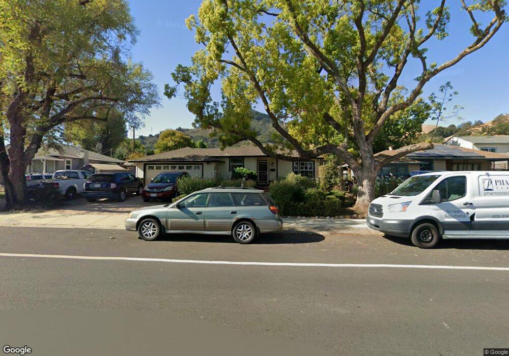
17653 Peak Ave Morgan Hill, CA 95037
Estimated Value: $839,389 - $1,069,000
3
Beds
1
Bath
1,022
Sq Ft
$951/Sq Ft
Est. Value
About This Home
This home is located at 17653 Peak Ave, Morgan Hill, CA 95037 and is currently estimated at $971,597, approximately $950 per square foot. 17653 Peak Ave is a home located in Santa Clara County with nearby schools including P.A. Walsh STEAM Academy, Britton Middle School, and Live Oak High School.
Ownership History
Date
Name
Owned For
Owner Type
Purchase Details
Closed on
Jul 10, 2012
Sold by
Conroy Wayne R and Conroy Barbara A
Bought by
Conroy Wayne R and Conroy Barbara A
Current Estimated Value
Home Financials for this Owner
Home Financials are based on the most recent Mortgage that was taken out on this home.
Original Mortgage
$212,500
Outstanding Balance
$146,408
Interest Rate
3.63%
Mortgage Type
New Conventional
Estimated Equity
$825,189
Purchase Details
Closed on
Dec 5, 1994
Sold by
Simcox Gary A and Simcox Rochelle L
Bought by
Herchkorn Lorrie A
Home Financials for this Owner
Home Financials are based on the most recent Mortgage that was taken out on this home.
Original Mortgage
$103,400
Interest Rate
9.08%
Create a Home Valuation Report for This Property
The Home Valuation Report is an in-depth analysis detailing your home's value as well as a comparison with similar homes in the area
Home Values in the Area
Average Home Value in this Area
Purchase History
| Date | Buyer | Sale Price | Title Company |
|---|---|---|---|
| Conroy Wayne R | -- | None Available | |
| Conroy Wayne R | -- | Chicago Title Company | |
| Herchkorn Lorrie A | $115,000 | Old Republic Title Company |
Source: Public Records
Mortgage History
| Date | Status | Borrower | Loan Amount |
|---|---|---|---|
| Open | Conroy Wayne R | $212,500 | |
| Previous Owner | Herchkorn Lorrie A | $103,400 |
Source: Public Records
Tax History
| Year | Tax Paid | Tax Assessment Tax Assessment Total Assessment is a certain percentage of the fair market value that is determined by local assessors to be the total taxable value of land and additions on the property. | Land | Improvement |
|---|---|---|---|---|
| 2025 | $1,319 | $103,209 | $18,914 | $84,295 |
| 2024 | $1,319 | $101,187 | $18,544 | $82,643 |
| 2023 | $1,302 | $99,204 | $18,181 | $81,023 |
| 2022 | $1,279 | $97,260 | $17,825 | $79,435 |
| 2021 | $1,247 | $95,354 | $17,476 | $77,878 |
| 2020 | $1,141 | $94,377 | $17,297 | $77,080 |
| 2019 | $1,168 | $92,527 | $16,958 | $75,569 |
| 2018 | $1,167 | $90,714 | $16,626 | $74,088 |
| 2017 | $1,154 | $88,936 | $16,300 | $72,636 |
| 2016 | $1,076 | $87,193 | $15,981 | $71,212 |
| 2015 | $1,063 | $85,884 | $15,741 | $70,143 |
| 2014 | $1,052 | $84,202 | $15,433 | $68,769 |
Source: Public Records
Map
Nearby Homes
- 17705 Hale Ave
- 515 W Dunne Ave
- 215 Longview Dr
- 945 Oak Park Dr
- 890 Oak Park Dr
- 915 Oak Park Dr
- 165 Del Monte Ln
- 16761 Dry Creek Ct
- 260 W Dunne Ave Unit 34
- 18013 Hillwood Ln
- 0A Hale Ave
- 640 Sparhawk Dr
- 18060 Monterey Rd
- 1075 Rose Orchard Ct
- 1095 Rose Orchard Ct
- 480 Winter Creek Way
- 17050 Depot St Unit 300
- 17050 Depot St Unit 200
- 18086 Monterey Rd
- 369 Calle Cerro
- 17657 Peak Ave
- 17649 Peak Ave
- 17661 Peak Ave
- 17645 Peak Ave
- 17665 Peak Ave
- 525 Claremont Dr
- 535 Claremont Dr
- 515 Claremont Dr
- 545 Claremont Dr
- 505 Claremont Dr
- 17669 Peak Ave
- 555 Claremont Dr
- 565 Claremont Dr
- 17673 Peak Ave
- 17635 Peak Ave
- 430 Claremont Dr
- 440 Claremont Dr
- 575 Claremont Dr
- 17677 Peak Ave
- 450 Claremont Dr
Your Personal Tour Guide
Ask me questions while you tour the home.