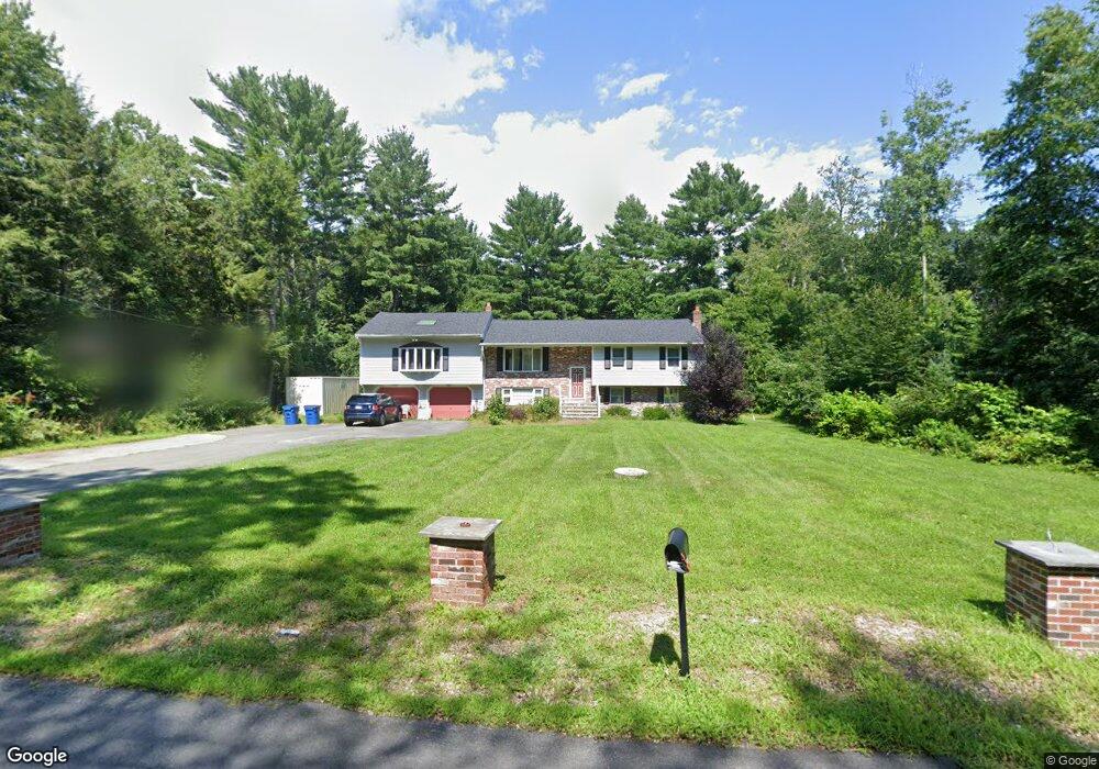
177 Chestnut St North Easton, MA 02356
Estimated Value: $711,723 - $761,000
4
Beds
3
Baths
1,812
Sq Ft
$406/Sq Ft
Est. Value
About This Home
This home is located at 177 Chestnut St, North Easton, MA 02356 and is currently estimated at $736,431, approximately $406 per square foot. 177 Chestnut St is a home located in Bristol County with nearby schools including Easton Middle School, St Mary's Catholic School, and Al-Noor Academy.
Ownership History
Date
Name
Owned For
Owner Type
Purchase Details
Closed on
May 2, 1997
Sold by
Joshua Rt
Bought by
Int Sandra D Geary
Current Estimated Value
Purchase Details
Closed on
Oct 28, 1992
Sold by
Dolloff Donna C and Dolloff Gry W
Bought by
Miranda Miria M
Home Financials for this Owner
Home Financials are based on the most recent Mortgage that was taken out on this home.
Original Mortgage
$141,000
Interest Rate
7.85%
Mortgage Type
Purchase Money Mortgage
Create a Home Valuation Report for This Property
The Home Valuation Report is an in-depth analysis detailing your home's value as well as a comparison with similar homes in the area
Home Values in the Area
Average Home Value in this Area
Purchase History
| Date | Buyer | Sale Price | Title Company |
|---|---|---|---|
| Int Sandra D Geary | $193,000 | -- | |
| Sandra D Geary Int D | $193,000 | -- | |
| Miranda Miria M | $188,000 | -- | |
| Miranda Miria M | $188,000 | -- |
Source: Public Records
Mortgage History
| Date | Status | Borrower | Loan Amount |
|---|---|---|---|
| Previous Owner | Miranda Miria M | $141,000 | |
| Previous Owner | Miranda Miria M | $141,000 |
Source: Public Records
Tax History Compared to Growth
Tax History
| Year | Tax Paid | Tax Assessment Tax Assessment Total Assessment is a certain percentage of the fair market value that is determined by local assessors to be the total taxable value of land and additions on the property. | Land | Improvement |
|---|---|---|---|---|
| 2025 | $7,867 | $630,400 | $374,000 | $256,400 |
| 2024 | $7,469 | $559,500 | $303,600 | $255,900 |
| 2023 | $7,539 | $516,700 | $303,600 | $213,100 |
| 2022 | $7,161 | $465,300 | $259,500 | $205,800 |
| 2021 | $6,943 | $448,500 | $242,700 | $205,800 |
| 2020 | $6,718 | $436,800 | $232,900 | $203,900 |
| 2019 | $6,253 | $391,800 | $218,300 | $173,500 |
| 2018 | $5,891 | $363,400 | $206,600 | $156,800 |
| 2017 | $5,656 | $348,700 | $206,600 | $142,100 |
| 2016 | $5,391 | $333,000 | $199,600 | $133,400 |
| 2015 | $5,138 | $306,200 | $172,800 | $133,400 |
| 2014 | $5,013 | $301,100 | $165,100 | $136,000 |
Source: Public Records
Map
Nearby Homes
- 4 Plantation Rd
- 29 Owl Ridge Rd
- 34 Kevins Way
- 23 Estelle Marsan Dr
- 16 Erick Rd Unit 34
- 98 Massapoag Ave
- 151 Stearns Ave
- 6 Erick Rd Unit 73
- 55 Eastman St
- 89 Massapoag Ave
- 157 Highland St
- 3 Cushing Ln
- 11 Hilltop Ln
- 28 Heidi Rd
- 36 Sierra Dr
- 218 Massapoag Ave
- 6 Pinebrook Ln Unit 6
- 631 East St Unit E203
- 212 Mill St
- 260 Massapoag Ave
- 177 Chestnut St
- 171 Chestnut St
- 181 Chestnut St
- 178 Chestnut St
- 167 Chestnut St
- 186 Chestnut St
- 182 Chestnut St
- 185A Chestnut St
- 174 Chestnut St
- 161 Chestnut St
- 185 Chestnut St
- 170 Chestnut St
- 153 Chestnut St
- 187 Chestnut St
- 164 Chestnut St
- 158 Chestnut St
- 189 Chestnut St
- 141 Chestnut St
- 162 Chestnut St
- 146 Chestnut St