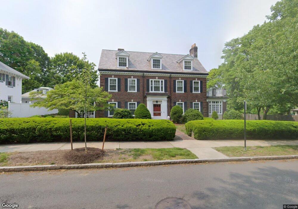
177 Dean Rd Brookline, MA 02445
Cleveland Circle NeighborhoodEstimated Value: $3,468,000 - $4,001,000
8
Beds
6
Baths
5,567
Sq Ft
$668/Sq Ft
Est. Value
About This Home
This home is located at 177 Dean Rd, Brookline, MA 02445 and is currently estimated at $3,717,903, approximately $667 per square foot. 177 Dean Rd is a home located in Norfolk County with nearby schools including John D. Runkle School, Brookline High School, and Torah Academy.
Ownership History
Date
Name
Owned For
Owner Type
Purchase Details
Closed on
Feb 11, 2014
Sold by
Casting Tanes and Casting Clotilde
Bought by
Casting Ret
Current Estimated Value
Purchase Details
Closed on
May 24, 2004
Sold by
Gudas Peter P and Gudas Valerie
Bought by
Casting Clotilde and Casting Tanes
Home Financials for this Owner
Home Financials are based on the most recent Mortgage that was taken out on this home.
Original Mortgage
$1,550,000
Interest Rate
5.75%
Mortgage Type
Purchase Money Mortgage
Create a Home Valuation Report for This Property
The Home Valuation Report is an in-depth analysis detailing your home's value as well as a comparison with similar homes in the area
Home Values in the Area
Average Home Value in this Area
Purchase History
| Date | Buyer | Sale Price | Title Company |
|---|---|---|---|
| Casting Ret | -- | -- | |
| Casting Clotilde | $1,550,000 | -- |
Source: Public Records
Mortgage History
| Date | Status | Borrower | Loan Amount |
|---|---|---|---|
| Previous Owner | Casting Clotilde | $1,550,000 |
Source: Public Records
Tax History
| Year | Tax Paid | Tax Assessment Tax Assessment Total Assessment is a certain percentage of the fair market value that is determined by local assessors to be the total taxable value of land and additions on the property. | Land | Improvement |
|---|---|---|---|---|
| 2025 | $33,098 | $3,353,400 | $1,457,700 | $1,895,700 |
| 2024 | $31,620 | $3,236,400 | $1,401,500 | $1,834,900 |
| 2023 | $27,950 | $2,803,400 | $1,001,300 | $1,802,100 |
| 2022 | $27,207 | $2,670,000 | $953,700 | $1,716,300 |
| 2021 | $25,160 | $2,567,300 | $917,000 | $1,650,300 |
| 2020 | $23,282 | $2,463,700 | $833,600 | $1,630,100 |
| 2019 | $21,986 | $2,346,400 | $793,900 | $1,552,500 |
| 2018 | $22,109 | $2,337,100 | $800,500 | $1,536,600 |
| 2017 | $21,783 | $2,204,800 | $755,200 | $1,449,600 |
| 2016 | $21,471 | $2,060,600 | $705,800 | $1,354,800 |
| 2015 | $20,568 | $1,925,800 | $659,600 | $1,266,200 |
| 2014 | $20,796 | $1,825,800 | $599,700 | $1,226,100 |
Source: Public Records
Map
Nearby Homes
- 401 Clinton Rd
- 43 Druce St
- 282 Buckminster Rd
- 41 Orkney Rd
- 31 Orkney Rd Unit 54
- 2400 Beacon St Unit 102
- 2400 Beacon St Unit 409
- 34 Hyslop Rd
- 6 Sutherland Rd Unit 41
- 0 Kilsyth Rd
- 4 7 Englewood Ave
- 47 Englewood Ave
- 37 Englewood Ave Unit 3
- 2420 Beacon St Unit 401
- 60 Sutherland Rd Unit 4
- 135 Beaconsfield Rd Unit 2
- 1778 Beacon St Unit 302
- 120 Seaver St Unit C-102
- 26 Chiswick Rd Unit 6
- 140 Kilsyth Rd Unit 8
- 185 Dean Rd
- 2 Willard Rd
- 184 Dean Rd
- 18 Willard Rd
- 9 Willard Rd
- 172 Dean Rd
- 163 Dean Rd
- 474 Chestnut Hill Ave
- 474 Chestnut Hill Ave Unit 2N
- 474 Chestnut Hill Ave Unit 3
- 19 Willard Rd
- 25 Willard Rd
- 164 Dean Rd
- 199 Dean Rd
- 357 Buckminster Rd
- 234 Fisher Ave
- 153 Dean Rd
- 355 Buckminster Rd
- 473 Chestnut Hill Ave Unit 3
- 462 Chestnut Hill Ave
Your Personal Tour Guide
Ask me questions while you tour the home.