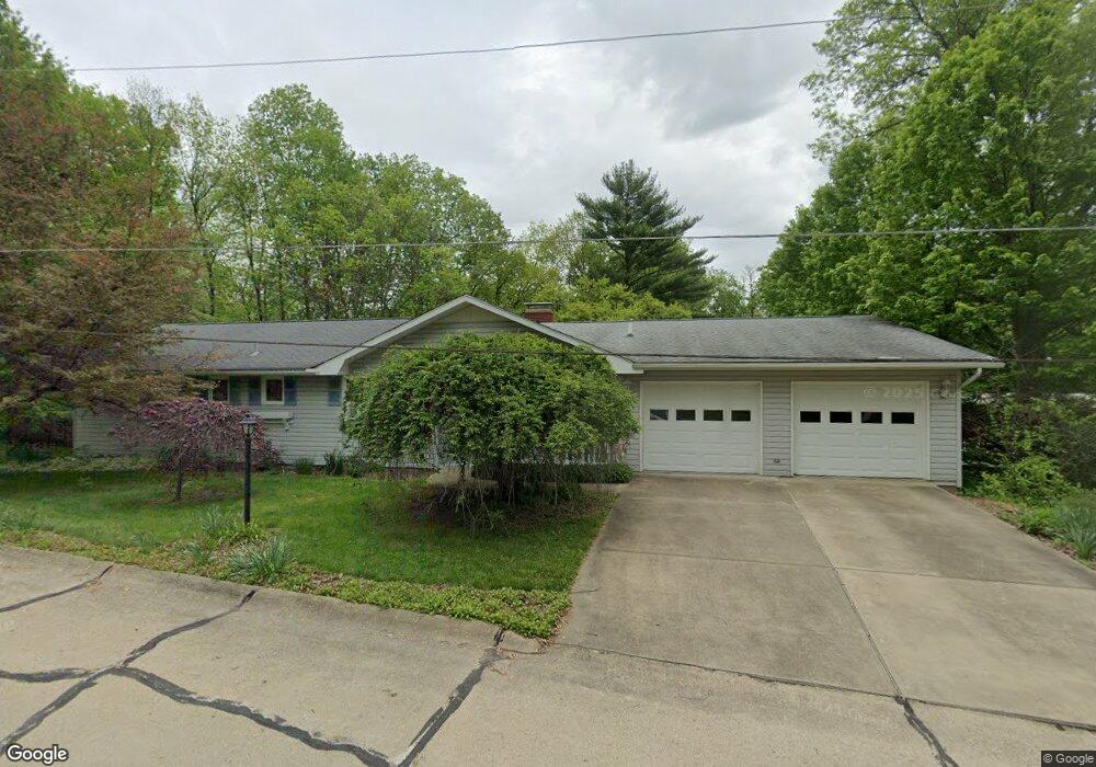
177 Lowery Ln New Concord, OH 43762
Estimated Value: $306,000 - $388,000
3
Beds
3
Baths
2,046
Sq Ft
$173/Sq Ft
Est. Value
About This Home
This home is located at 177 Lowery Ln, New Concord, OH 43762 and is currently estimated at $353,889, approximately $172 per square foot. 177 Lowery Ln is a home located in Muskingum County with nearby schools including New Concord Elementary School, Larry Miller Intermediate Elementary School, and East Muskingum Middle School.
Ownership History
Date
Name
Owned For
Owner Type
Purchase Details
Closed on
May 1, 2018
Sold by
Johnston Laura D
Bought by
Nowakowski Joseph M
Current Estimated Value
Purchase Details
Closed on
Jul 28, 2000
Sold by
Ng Jeannie L
Bought by
Nowakowski Joseph M and Johnston Laura D
Home Financials for this Owner
Home Financials are based on the most recent Mortgage that was taken out on this home.
Original Mortgage
$116,000
Interest Rate
8.27%
Mortgage Type
New Conventional
Create a Home Valuation Report for This Property
The Home Valuation Report is an in-depth analysis detailing your home's value as well as a comparison with similar homes in the area
Home Values in the Area
Average Home Value in this Area
Purchase History
| Date | Buyer | Sale Price | Title Company |
|---|---|---|---|
| Nowakowski Joseph M | -- | None Available | |
| Nowakowski Joseph M | $129,000 | -- |
Source: Public Records
Mortgage History
| Date | Status | Borrower | Loan Amount |
|---|---|---|---|
| Previous Owner | Nowakowski Joseph M | $116,000 |
Source: Public Records
Tax History Compared to Growth
Tax History
| Year | Tax Paid | Tax Assessment Tax Assessment Total Assessment is a certain percentage of the fair market value that is determined by local assessors to be the total taxable value of land and additions on the property. | Land | Improvement |
|---|---|---|---|---|
| 2024 | $3,094 | $88,445 | $12,635 | $75,810 |
| 2023 | $2,659 | $70,280 | $12,635 | $57,645 |
| 2022 | $2,607 | $70,280 | $12,635 | $57,645 |
| 2021 | $2,577 | $70,280 | $12,635 | $57,645 |
| 2020 | $2,644 | $70,280 | $12,635 | $57,645 |
| 2019 | $2,592 | $70,280 | $12,635 | $57,645 |
| 2018 | $2,459 | $70,280 | $12,635 | $57,645 |
| 2017 | $2,240 | $57,155 | $12,635 | $44,520 |
| 2016 | $2,243 | $57,160 | $12,640 | $44,520 |
| 2015 | $2,273 | $57,160 | $12,640 | $44,520 |
| 2013 | $2,424 | $57,160 | $12,640 | $44,520 |
Source: Public Records
Map
Nearby Homes
- 110 Cherry Ln
- 112 Thompson Ave
- 8 E Main St
- 67 E Main St
- 12985 John Glenn School Rd
- 1420 Glenn Hwy
- 0 Maple Ln
- 0 Rix Mills Rd
- 0 Homestead Dr Unit 11611647
- 0 Homestead Dr Unit 5174212
- Lot 18 & 19 Greenbriar Dr
- 61220 Kadon Dr
- 3029 Best Rd
- 60040 Bliss Rd
- 0 Norfield Unit 5174011
- 0 Norfield Unit 5173946
- 135 S Moose Eye Rd
- 3859 Mayfair Ln
- 101 N Sundale Rd
- 3278 Rough & Ready Rd