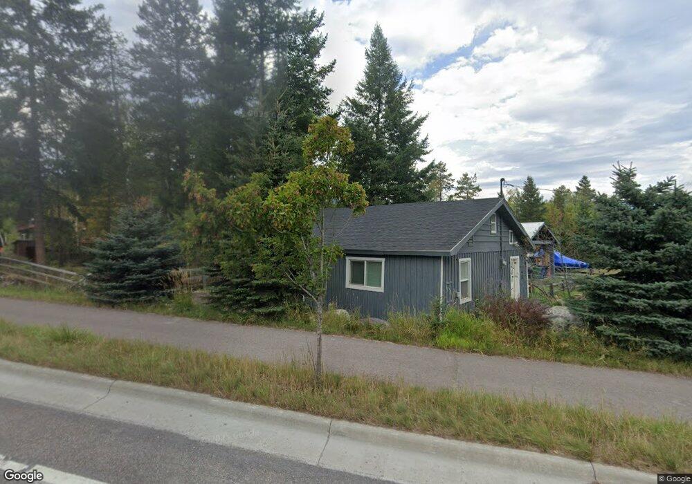
1770 Us Highway 93 W Whitefish, MT 59937
Estimated Value: $575,000 - $751,000
1
Bed
1
Bath
840
Sq Ft
$762/Sq Ft
Est. Value
About This Home
This home is located at 1770 Us Highway 93 W, Whitefish, MT 59937 and is currently estimated at $640,361, approximately $762 per square foot. 1770 Us Highway 93 W is a home located in Flathead County with nearby schools including L.A. Muldown School, Whitefish Middle School, and Whitefish High School.
Ownership History
Date
Name
Owned For
Owner Type
Purchase Details
Closed on
Jan 5, 2017
Sold by
Mitchell Phillip and Mitchell Belina
Bought by
Kepenek Ahmet C and Crabtree Severn G
Current Estimated Value
Home Financials for this Owner
Home Financials are based on the most recent Mortgage that was taken out on this home.
Original Mortgage
$145,350
Outstanding Balance
$119,816
Interest Rate
4.13%
Mortgage Type
New Conventional
Estimated Equity
$520,545
Create a Home Valuation Report for This Property
The Home Valuation Report is an in-depth analysis detailing your home's value as well as a comparison with similar homes in the area
Home Values in the Area
Average Home Value in this Area
Purchase History
| Date | Buyer | Sale Price | Title Company |
|---|---|---|---|
| Kepenek Ahmet C | -- | None Available |
Source: Public Records
Mortgage History
| Date | Status | Borrower | Loan Amount |
|---|---|---|---|
| Open | Kepenek Ahmet C | $145,350 |
Source: Public Records
Tax History Compared to Growth
Tax History
| Year | Tax Paid | Tax Assessment Tax Assessment Total Assessment is a certain percentage of the fair market value that is determined by local assessors to be the total taxable value of land and additions on the property. | Land | Improvement |
|---|---|---|---|---|
| 2025 | $2,073 | $617,900 | $0 | $0 |
| 2024 | $2,225 | $443,400 | $0 | $0 |
| 2023 | $2,831 | $443,400 | $0 | $0 |
| 2022 | $2,296 | $231,500 | $0 | $0 |
| 2021 | $1,915 | $231,500 | $0 | $0 |
| 2020 | $2,216 | $201,800 | $0 | $0 |
| 2019 | $2,345 | $201,800 | $0 | $0 |
| 2018 | $2,387 | $206,300 | $0 | $0 |
| 2017 | $1,671 | $206,300 | $0 | $0 |
| 2016 | $4,454 | $182,700 | $0 | $0 |
| 2015 | $1,483 | $182,700 | $0 | $0 |
| 2014 | $1,499 | $114,692 | $0 | $0 |
Source: Public Records
Map
Nearby Homes
- 327 Rock Ridge Rd
- 1038 Mountain Park Dr Unit B
- 205 Fox Hollow Ln
- 1331 Nelson Ln Unit Cabin I
- 104 Stumptown Loop
- 318 Fairway Dr
- 308 Haugen Heights Rd
- 717 Ice House Rd
- 754 Icehouse Rd
- 270 Lake Park Ln
- 271 Lake Park Ln
- 1030 State Park Rd
- 1028 State Park Rd
- 1130 Birch Point Dr Unit B
- 309 Fairway Dr
- 1320 W Lakeshore Dr
- 314 Fairway Dr
- 713 2nd St W
- 750 & 810 Birch Point Dr
- NHN Tract 2 Wolf Tail Pines Rd
- 1770 Us Highway 93 W
- 1876 Us Highway 93 W
- 2045 Lion Mountain Rd
- 2045 Lion Mountain Loop Rd
- 2035 Lion Mountain Loop Rd
- 1915 Highway 93 W
- 2011 Lion Mountain Loop Rd
- 2011 Lion Mountain Loop Rd
- 1915 Us Highway 93 W
- 2033 Lion Mountain Loop Rd
- 1960 Highway 93 W
- 1960 Us Highway 93 W
- 1960 Bench Mark Ln
- 1735 Us Highway 93 W
- 1735 U S 93
- 2009 &2011 Lion Mountain Rd
- 1960 Benchmark Ln
- 1950 Us Highway 93 W
- 1950 Highway 93 W
- 1765 Us Highway 93 W