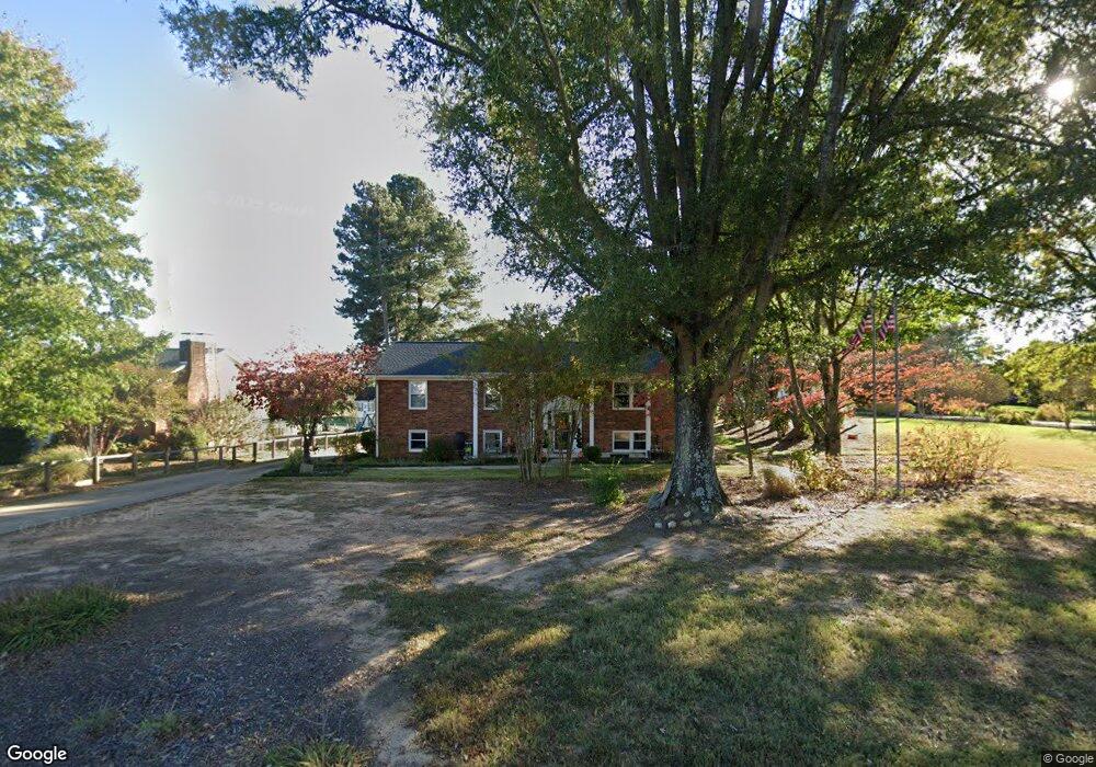
1771 Enterprise Rd Lexington, NC 27295
Estimated Value: $324,000 - $369,000
4
Beds
3
Baths
2,710
Sq Ft
$128/Sq Ft
Est. Value
About This Home
This home is located at 1771 Enterprise Rd, Lexington, NC 27295 and is currently estimated at $347,487, approximately $128 per square foot. 1771 Enterprise Rd is a home located in Davidson County with nearby schools including Northwest Elementary School, North Davidson Middle School, and North Davidson High School.
Ownership History
Date
Name
Owned For
Owner Type
Purchase Details
Closed on
Feb 27, 2007
Sold by
Tusler Judith P
Bought by
Michalak Eddie and Michalak Patricia
Current Estimated Value
Home Financials for this Owner
Home Financials are based on the most recent Mortgage that was taken out on this home.
Original Mortgage
$142,080
Outstanding Balance
$87,773
Interest Rate
6.64%
Mortgage Type
Purchase Money Mortgage
Estimated Equity
$259,714
Purchase Details
Closed on
Oct 30, 2001
Sold by
Horton Marshall R and Horton Susan B
Bought by
Tusler Judith P
Purchase Details
Closed on
Aug 1, 2000
Bought by
Horton Marshall R and Horton Susan B
Purchase Details
Closed on
Mar 1, 1987
Purchase Details
Closed on
Sep 1, 1986
Create a Home Valuation Report for This Property
The Home Valuation Report is an in-depth analysis detailing your home's value as well as a comparison with similar homes in the area
Home Values in the Area
Average Home Value in this Area
Purchase History
| Date | Buyer | Sale Price | Title Company |
|---|---|---|---|
| Michalak Eddie | $178,000 | None Available | |
| Tusler Judith P | $145,000 | -- | |
| Horton Marshall R | $135,000 | -- | |
| -- | $72,000 | -- | |
| -- | $67,500 | -- |
Source: Public Records
Mortgage History
| Date | Status | Borrower | Loan Amount |
|---|---|---|---|
| Open | Michalak Eddie | $142,080 |
Source: Public Records
Tax History Compared to Growth
Tax History
| Year | Tax Paid | Tax Assessment Tax Assessment Total Assessment is a certain percentage of the fair market value that is determined by local assessors to be the total taxable value of land and additions on the property. | Land | Improvement |
|---|---|---|---|---|
| 2025 | $1,234 | $195,770 | $0 | $0 |
| 2024 | $1,234 | $195,770 | $0 | $0 |
| 2023 | $1,234 | $195,770 | $0 | $0 |
| 2022 | $1,234 | $195,770 | $0 | $0 |
| 2021 | $1,234 | $195,770 | $0 | $0 |
| 2020 | $988 | $156,740 | $0 | $0 |
| 2019 | $972 | $156,740 | $0 | $0 |
| 2018 | $971 | $156,560 | $0 | $0 |
| 2017 | $971 | $156,560 | $0 | $0 |
| 2016 | $971 | $156,560 | $0 | $0 |
| 2015 | $971 | $156,560 | $0 | $0 |
| 2014 | $1,101 | $177,530 | $0 | $0 |
Source: Public Records
Map
Nearby Homes
- 910 Berrier Rd
- 266 Hickory Hills Ln
- 259 Hickory Hills Ln
- 100 Burkeview Ct
- 185 Valley Hill Ln
- 182 Doe Crossing
- 172 Crossfield Ct
- 153 Rock Cress Dr
- 486 Yarrow Dr
- 177 Rock Cress Dr
- 470 Yarrow Dr
- 177 Lavender Ln
- 191 Lavender Ln
- 205 Lavender Ln
- 201 Rock Cress Dr
- 120 Lavender Ln
- 217 Lavender Ln
- 213 Rock Cress Dr
- 146 Lavender Ln
- 160 Lavender Ln
- 1753 Enterprise Rd
- 1750 Enterprise Rd
- 1712 Enterprise Rd
- 1848 Enterprise Rd
- 1886 Enterprise Rd
- 1619 Enterprise Rd
- 1940 Enterprise Rd
- 1587 Enterprise Rd
- 1920 Enterprise Rd
- 1600 Enterprise Rd
- 139 Preston Ct
- 1559 Enterprise Rd
- 163 Preston Ct
- 172 Springfield Ct
- 167 Springfield Ct
- 1535 Enterprise Rd
- 1540 Enterprise Rd
- 1982 Enterprise Rd
- 179 Preston Ct
- 350 Burkewood Dr