Estimated Value: $414,237 - $484,000
3
Beds
3
Baths
1,788
Sq Ft
$249/Sq Ft
Est. Value
About This Home
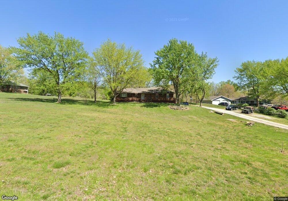
This home is located at 17711 Loop Rd, Holt, MO 64048 and is currently estimated at $445,809, approximately $249 per square foot. 17711 Loop Rd is a home located in Clay County with nearby schools including Kearney Junior High School, Kearney High School, and Northern Hills Christian Academy.
Ownership History
Date
Name
Owned For
Owner Type
Purchase Details
Closed on
Jan 23, 2024
Sold by
Powell Michael V and Powell Amy M
Bought by
Powell Michael V
Current Estimated Value
Home Financials for this Owner
Home Financials are based on the most recent Mortgage that was taken out on this home.
Original Mortgage
$146,250
Outstanding Balance
$143,527
Interest Rate
6.62%
Mortgage Type
New Conventional
Estimated Equity
$302,282
Purchase Details
Closed on
Jun 27, 2002
Sold by
Calhoun Steven L and Calhoun Carol Rae
Bought by
Powell Michael and Powell Amy M
Home Financials for this Owner
Home Financials are based on the most recent Mortgage that was taken out on this home.
Original Mortgage
$134,000
Interest Rate
6.89%
Create a Home Valuation Report for This Property
The Home Valuation Report is an in-depth analysis detailing your home's value as well as a comparison with similar homes in the area
Home Values in the Area
Average Home Value in this Area
Purchase History
| Date | Buyer | Sale Price | Title Company |
|---|---|---|---|
| Powell Michael V | -- | None Listed On Document | |
| Powell Michael V | -- | None Listed On Document | |
| Powell Michael | -- | United Title Company |
Source: Public Records
Mortgage History
| Date | Status | Borrower | Loan Amount |
|---|---|---|---|
| Open | Powell Michael V | $146,250 | |
| Closed | Powell Michael V | $146,250 | |
| Previous Owner | Powell Michael | $134,000 |
Source: Public Records
Tax History
| Year | Tax Paid | Tax Assessment Tax Assessment Total Assessment is a certain percentage of the fair market value that is determined by local assessors to be the total taxable value of land and additions on the property. | Land | Improvement |
|---|---|---|---|---|
| 2025 | $3,176 | $54,320 | -- | -- |
| 2024 | $3,176 | $47,270 | -- | -- |
| 2023 | $3,031 | $47,270 | $0 | $0 |
| 2022 | $2,558 | $39,100 | $0 | $0 |
| 2021 | $2,561 | $39,102 | $5,700 | $33,402 |
| 2020 | $2,542 | $35,950 | $0 | $0 |
| 2019 | $2,551 | $35,950 | $0 | $0 |
Source: Public Records
Map
Nearby Homes
- 17504 State Route 33
- 16816 Landmark Loop
- 0 Lot 5 Arnold Park Lot N A Unit HMS2572371
- 0 Lot 3 Arnold Park Lot N A Unit HMS2572330
- Tract 2 Nation Rd
- Lot 5 Arnold Park
- Tbd Northeast 188th St
- TBD 188th Street N A
- 15420 NE 162nd St
- 19616 NE 190th St
- 1200 W 10th Ave
- 18317 Plattsburg Rd
- 113 E Frank St
- 915 Englewood Dr
- 911 Crestridge Dr
- 102 W Lawrence St
- 19412 Shanks Rd
- 803 Englewood Dr
- 12406 NE 172nd St
- 18703 Plattsburg Rd
- 17705 Loop Rd
- 17725 Loop Rd
- 17712 Loop Rd
- 17722 Loop Rd
- 17704 Loop Rd
- 17804 Loop Rd
- 17811 Loop Rd
- 17720 State Route 33
- 17721 Talon Dr
- 17713 Talon Dr
- 17701 Talon Dr
- 17816 Loop Rd
- 17720 Missouri 33
- 17805 Talon Dr
- 17815 Talon Dr
- 17820 Loop Rd
- 17706 Talon Dr
- 17718 Talon Dr
- 17812 State Route 33
- 17706 State Route 33
Your Personal Tour Guide
Ask me questions while you tour the home.