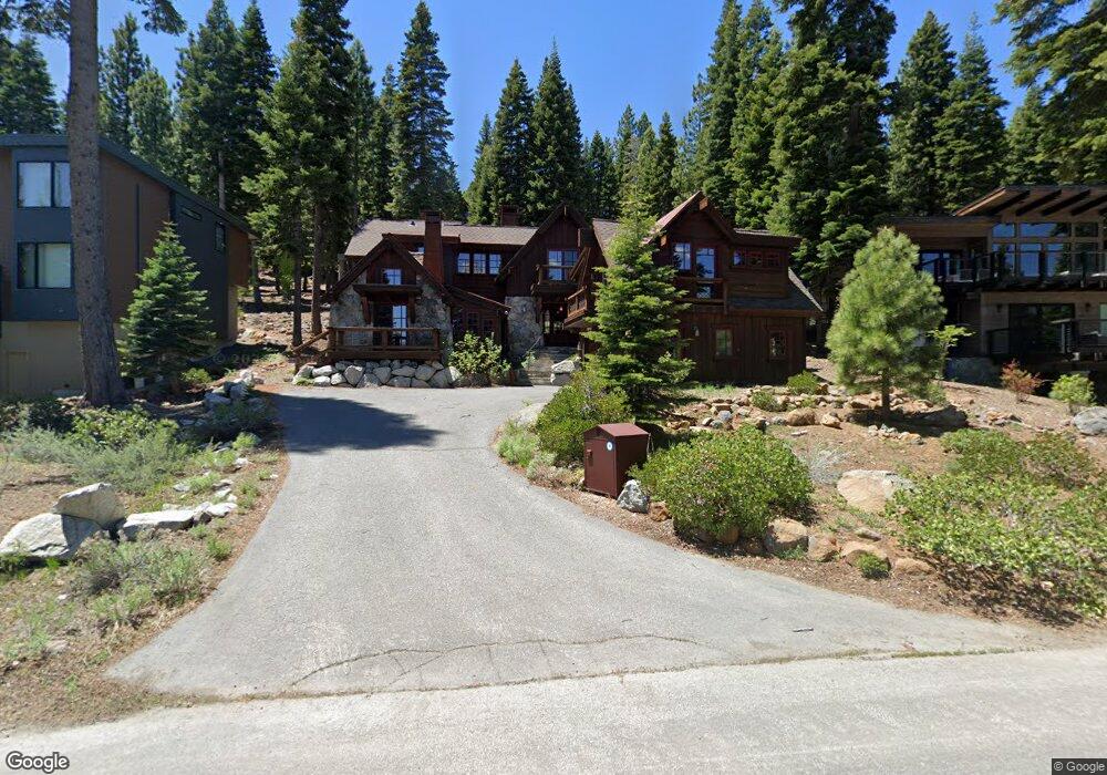
1774 Grouse Ridge Truckee, CA 96161
South Truckee NeighborhoodEstimated Value: $3,303,067 - $4,339,000
4
Beds
5
Baths
3,697
Sq Ft
$1,002/Sq Ft
Est. Value
About This Home
This home is located at 1774 Grouse Ridge, Truckee, CA 96161 and is currently estimated at $3,705,356, approximately $1,002 per square foot. 1774 Grouse Ridge is a home located in Placer County with nearby schools including Truckee Elementary School, Alder Creek Middle School, and Tahoe Truckee High School.
Ownership History
Date
Name
Owned For
Owner Type
Purchase Details
Closed on
Oct 25, 2012
Sold by
Margherita Eugene and Margherita Joellen
Bought by
Kennedy Giles
Current Estimated Value
Home Financials for this Owner
Home Financials are based on the most recent Mortgage that was taken out on this home.
Original Mortgage
$1,556,750
Outstanding Balance
$277,142
Interest Rate
3.43%
Mortgage Type
New Conventional
Estimated Equity
$3,428,214
Purchase Details
Closed on
Oct 9, 2012
Sold by
Ishikawa Naomi Joann
Bought by
Kennedy Giles
Home Financials for this Owner
Home Financials are based on the most recent Mortgage that was taken out on this home.
Original Mortgage
$1,556,750
Outstanding Balance
$277,142
Interest Rate
3.43%
Mortgage Type
New Conventional
Estimated Equity
$3,428,214
Create a Home Valuation Report for This Property
The Home Valuation Report is an in-depth analysis detailing your home's value as well as a comparison with similar homes in the area
Home Values in the Area
Average Home Value in this Area
Purchase History
| Date | Buyer | Sale Price | Title Company |
|---|---|---|---|
| Kennedy Giles | $2,395,000 | Fidelity Title | |
| Kennedy Giles | -- | Fidelity Title |
Source: Public Records
Mortgage History
| Date | Status | Borrower | Loan Amount |
|---|---|---|---|
| Open | Kennedy Giles | $1,556,750 |
Source: Public Records
Tax History Compared to Growth
Tax History
| Year | Tax Paid | Tax Assessment Tax Assessment Total Assessment is a certain percentage of the fair market value that is determined by local assessors to be the total taxable value of land and additions on the property. | Land | Improvement |
|---|---|---|---|---|
| 2025 | $33,181 | $2,949,260 | $800,423 | $2,148,837 |
| 2023 | $33,181 | $2,834,739 | $769,343 | $2,065,396 |
| 2022 | $32,507 | $2,779,157 | $754,258 | $2,024,899 |
| 2021 | $30,890 | $2,724,665 | $739,469 | $1,985,196 |
| 2020 | $31,223 | $2,696,728 | $731,887 | $1,964,841 |
| 2019 | $31,413 | $2,643,852 | $717,537 | $1,926,315 |
| 2018 | $30,291 | $2,592,013 | $703,468 | $1,888,545 |
| 2017 | $29,799 | $2,541,190 | $689,675 | $1,851,515 |
| 2016 | $29,636 | $2,491,363 | $676,152 | $1,815,211 |
| 2015 | $28,921 | $2,453,941 | $665,996 | $1,787,945 |
| 2014 | $28,504 | $2,405,873 | $652,951 | $1,752,922 |
Source: Public Records
Map
Nearby Homes
- 2221 Silver Fox
- 970 Northstar Dr Unit 105
- 970 Northstar Dr Unit 306
- 2203 Silver Fox Unit New Year's Week - Sh
- 4001 Northstar Dr Unit 509
- 4001 Northstar Dr Unit 510
- 1750 Grouse Ridge Rd
- 5001 Northstar Dr Unit 302
- 5001 Northstar Dr Unit 306
- 5001 Northstar Dr Unit 207 March Wk. 1 - Sh
- 3001 Northstar Dr Unit 305
- 3001 Northstar Dr Unit 205
- 7001 Northstar Dr Unit 406
- 7001 Northstar Dr Unit 507
- 7001 Northstar Dr Unit 412
- 2000 N Village Dr Unit 233
- 8001 Northstar Dr Unit 408
- 8001 Northstar Dr Unit 414 - 2ND WK FEB SUP
- 8001 Northstar Dr Unit 207
- 8001 Northstar Dr Unit 214
- 1774 Grouse Ridge Rd
- 1776 Grouse Ridge Rd
- 1778 Grouse Ridge
- 2221 Silver Sox
- 1775 Grouse Ridge
- 1768 Grouse Ridge
- 1777 Grouse Ridge
- 1771 Grouse Ridge
- 1780 Grouse Ridge
- 2223 Silver Fox Ct
- 2215 Silver Fox
- 1779 Grouse Ridge
- 1769 Grouse Ridge
- 1766 Grouse Ridge
- 1767 Grouse Ridge
- 2211 Silver Fox Ct
- 1764 Grouse Ridge
- 2220 Silver Fox
- 2217 Silver Fox
- 2227 Silver Fox