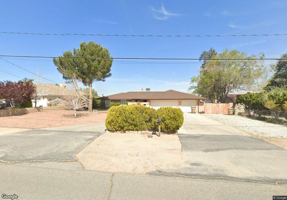
17762 Hinton St Hesperia, CA 92345
The Mesa NeighborhoodEstimated Value: $439,000 - $590,000
3
Beds
3
Baths
2,000
Sq Ft
$242/Sq Ft
Est. Value
About This Home
This home is located at 17762 Hinton St, Hesperia, CA 92345 and is currently estimated at $484,229, approximately $242 per square foot. 17762 Hinton St is a home located in San Bernardino County with nearby schools including Lime Street Elementary School, Ranchero Middle School, and Sultana High School.
Ownership History
Date
Name
Owned For
Owner Type
Purchase Details
Closed on
Feb 6, 1999
Sold by
Taylor Lawrence W and Taylor Joanne S
Bought by
Mourino Robert L and Mourino Linda J
Current Estimated Value
Home Financials for this Owner
Home Financials are based on the most recent Mortgage that was taken out on this home.
Original Mortgage
$118,706
Interest Rate
6.79%
Mortgage Type
FHA
Create a Home Valuation Report for This Property
The Home Valuation Report is an in-depth analysis detailing your home's value as well as a comparison with similar homes in the area
Home Values in the Area
Average Home Value in this Area
Purchase History
| Date | Buyer | Sale Price | Title Company |
|---|---|---|---|
| Mourino Robert L | $119,500 | First American Title Ins Co |
Source: Public Records
Mortgage History
| Date | Status | Borrower | Loan Amount |
|---|---|---|---|
| Previous Owner | Mourino Robert L | $118,706 |
Source: Public Records
Tax History
| Year | Tax Paid | Tax Assessment Tax Assessment Total Assessment is a certain percentage of the fair market value that is determined by local assessors to be the total taxable value of land and additions on the property. | Land | Improvement |
|---|---|---|---|---|
| 2025 | $2,042 | $187,341 | $31,846 | $155,495 |
| 2024 | $1,995 | $183,668 | $31,222 | $152,446 |
| 2023 | $1,972 | $180,067 | $30,610 | $149,457 |
| 2022 | $1,925 | $176,536 | $30,010 | $146,526 |
| 2021 | $1,890 | $173,075 | $29,422 | $143,653 |
| 2020 | $1,867 | $171,300 | $29,120 | $142,180 |
| 2019 | $1,827 | $167,941 | $28,549 | $139,392 |
| 2018 | $1,791 | $164,648 | $27,989 | $136,659 |
| 2017 | $1,759 | $161,419 | $27,440 | $133,979 |
| 2016 | $1,720 | $158,254 | $26,902 | $131,352 |
| 2015 | $1,698 | $155,877 | $26,498 | $129,379 |
| 2014 | $1,674 | $152,824 | $25,979 | $126,845 |
Source: Public Records
Map
Nearby Homes
- 17850 Bangor Ave
- 17936 Westlawn St
- 17986 Westlawn St
- 8732 Pico Ave
- 18090 Hinton St
- 17788 Buckthorn Ave
- 17454 Buckthorn Ave
- 17405 Adobe St
- 17487 Aspen St
- 17314 Aspen St
- 17340 Buckthorn Ave
- 18186 Bangor Ave
- 18250 Preston St
- 17775 Sultana St
- 8960 Buckthorn Ave
- 17600 Orange St
- 18146 Orange St
- 8323 Peach Ave
- 17185 Fremontia St Unit A
- 8411 Buckthorn Ave
- 17758 Hinton St
- 17776 Hinton St
- 17780 Hinton St
- 17744 Hinton St
- 17709 Bangor Ave
- 17717 Bangor Ave
- 17775 Hinton St
- 17759 Hinton St
- 17725 Bangor Ave
- 17796 Hinton St
- 17785 Hinton St
- 17691 Bangor Ave
- 17741 Hinton St
- 17737 Bangor Ave
- 17732 Hinton St
- 17810 Hinton St
- 17801 Hinton St
- 17836 Hinton St
- 17814 Westlawn St
- 17751 Bangor Ave
Your Personal Tour Guide
Ask me questions while you tour the home.