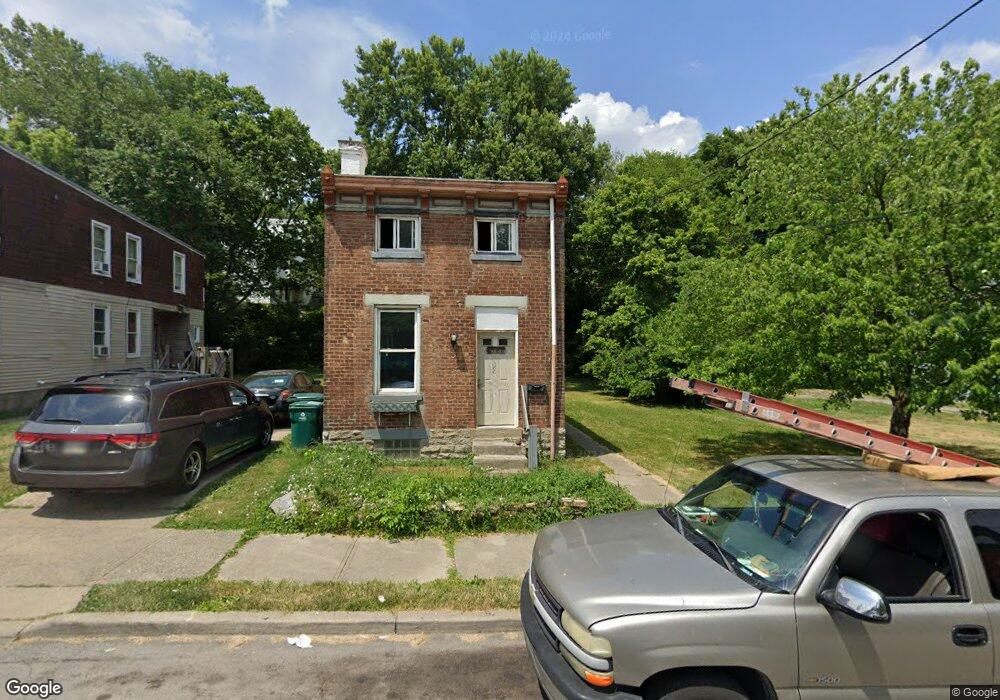
1778 Carll St Cincinnati, OH 45225
North Fairmount NeighborhoodEstimated Value: $96,335 - $104,000
2
Beds
1
Bath
1,527
Sq Ft
$65/Sq Ft
Est. Value
About This Home
This home is located at 1778 Carll St, Cincinnati, OH 45225 and is currently estimated at $99,445, approximately $65 per square foot. 1778 Carll St is a home located in Hamilton County with nearby schools including Ethel M. Taylor Academy, Robert A. Taft Information Technology High School, and Western Hills High School.
Ownership History
Date
Name
Owned For
Owner Type
Purchase Details
Closed on
Dec 30, 2009
Sold by
Hake Richard and Hake Dawn
Bought by
A Cut Above Plumbing Llc
Current Estimated Value
Purchase Details
Closed on
Feb 15, 2007
Sold by
Harris Johnny
Bought by
Hake Richard and Hake Dawn
Purchase Details
Closed on
Mar 23, 1995
Sold by
North Fairmount Community Center Inc
Bought by
Harris Johnny
Home Financials for this Owner
Home Financials are based on the most recent Mortgage that was taken out on this home.
Original Mortgage
$36,100
Interest Rate
8.82%
Create a Home Valuation Report for This Property
The Home Valuation Report is an in-depth analysis detailing your home's value as well as a comparison with similar homes in the area
Home Values in the Area
Average Home Value in this Area
Purchase History
| Date | Buyer | Sale Price | Title Company |
|---|---|---|---|
| A Cut Above Plumbing Llc | $12,000 | Attorney | |
| Hake Richard | $18,000 | Attorney | |
| Harris Johnny | -- | -- |
Source: Public Records
Mortgage History
| Date | Status | Borrower | Loan Amount |
|---|---|---|---|
| Previous Owner | Harris Johnny | $36,100 |
Source: Public Records
Tax History Compared to Growth
Tax History
| Year | Tax Paid | Tax Assessment Tax Assessment Total Assessment is a certain percentage of the fair market value that is determined by local assessors to be the total taxable value of land and additions on the property. | Land | Improvement |
|---|---|---|---|---|
| 2024 | $821 | $12,870 | $1,229 | $11,641 |
| 2023 | $823 | $12,870 | $1,229 | $11,641 |
| 2022 | $615 | $8,632 | $1,243 | $7,389 |
| 2021 | $603 | $8,632 | $1,243 | $7,389 |
| 2020 | $604 | $8,632 | $1,243 | $7,389 |
| 2019 | $604 | $7,848 | $1,131 | $6,717 |
| 2018 | $604 | $7,848 | $1,131 | $6,717 |
| 2017 | $582 | $7,848 | $1,131 | $6,717 |
| 2016 | $312 | $4,068 | $1,411 | $2,657 |
| 2015 | $279 | $4,068 | $1,411 | $2,657 |
| 2014 | $280 | $4,068 | $1,411 | $2,657 |
| 2013 | $282 | $4,026 | $1,397 | $2,629 |
Source: Public Records
Map
Nearby Homes
- 1770 Carll St
- 1797 Denham St
- 1756 Carll St
- 1808 Carll St
- 1854 Carll St
- 2568 Trevor Place
- 1721 Sutter Ave
- 1859 Baltimore Ave
- 1704 Pulte St
- 1674 Baltimore Ave
- 1646 Pulte St
- 1642 Sutter Ave
- 1623 Sutter Ave
- 2911 Moosewood Ct
- 2521 Seegar Ave
- 2652 Linden St
- 2650 Linden St
- 2654 Linden St
- 2658 Linden St
- 2656 Linden St
- 1782 Carll St
- 1774 Carll St
- 1772 Carll St
- 1772 Carll St Unit 1774
- 1779 Denham St
- 1781 Denham St
- 1768 Carll St
- 1773 Denham St
- 1785 Denham St
- 1777 Denham St
- 1777 Denham St
- 1771 Denham St
- 1766 Carll St
- 1787 Denham St
- 1769 Carll St
- 1788 Carll St
- 1767 Denham St
- 1765 Denham St
- 1793 Denham St Unit 1791
- 1793 Denham St