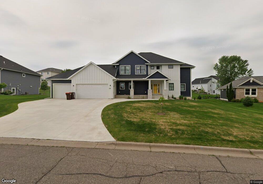
1778 Greystone Rd Hastings, MN 55033
Hastings-Marshan Township NeighborhoodEstimated Value: $627,000 - $943,000
6
Beds
5
Baths
2,990
Sq Ft
$258/Sq Ft
Est. Value
About This Home
This home is located at 1778 Greystone Rd, Hastings, MN 55033 and is currently estimated at $772,274, approximately $258 per square foot. 1778 Greystone Rd is a home located in Dakota County with nearby schools including Christa Mcauliffe Elementary School, Hastings Middle School, and Hastings High School.
Ownership History
Date
Name
Owned For
Owner Type
Purchase Details
Closed on
Dec 17, 2020
Sold by
Duane R Wallin And Winston R Wallin Lllp
Bought by
Mclean Molly and Mclean Christopher
Current Estimated Value
Home Financials for this Owner
Home Financials are based on the most recent Mortgage that was taken out on this home.
Original Mortgage
$45,000
Outstanding Balance
$40,063
Interest Rate
2.7%
Mortgage Type
Future Advance Clause Open End Mortgage
Estimated Equity
$732,211
Create a Home Valuation Report for This Property
The Home Valuation Report is an in-depth analysis detailing your home's value as well as a comparison with similar homes in the area
Home Values in the Area
Average Home Value in this Area
Purchase History
| Date | Buyer | Sale Price | Title Company |
|---|---|---|---|
| Mclean Molly | $90,000 | Chicago Title Insurance Co | |
| Mclean Molly Molly | $90,000 | -- |
Source: Public Records
Mortgage History
| Date | Status | Borrower | Loan Amount |
|---|---|---|---|
| Open | Mclean Molly | $45,000 | |
| Closed | Mclean Molly Molly | $45,000 |
Source: Public Records
Tax History Compared to Growth
Tax History
| Year | Tax Paid | Tax Assessment Tax Assessment Total Assessment is a certain percentage of the fair market value that is determined by local assessors to be the total taxable value of land and additions on the property. | Land | Improvement |
|---|---|---|---|---|
| 2024 | $1,790 | $492,200 | $121,000 | $371,200 |
| 2023 | $1,790 | $128,700 | $121,200 | $7,500 |
| 2022 | $1,406 | $108,900 | $108,900 | $0 |
| 2021 | $1,672 | $94,700 | $94,700 | $0 |
| 2020 | $1,646 | $112,000 | $112,000 | $0 |
| 2019 | $1,650 | $106,700 | $106,700 | $0 |
| 2018 | $1,091 | $101,600 | $101,600 | $0 |
| 2017 | $506 | $96,800 | $96,800 | $0 |
| 2016 | $262 | $90,400 | $90,400 | $0 |
| 2015 | -- | $15,000 | $15,000 | $0 |
| 2014 | -- | $0 | $0 | $0 |
Source: Public Records
Map
Nearby Homes
- 1797 Cobblestone Ct
- 1757 Brandlewood Ct
- 1796 Cobblestone Ct
- 1765 Brandlewood Ct
- Alley Plan at Heritage Ridge
- Alley Plan at Heritage Ridge - Villas
- Kenny Plan at Heritage Ridge - Villas
- Sully Plan at Heritage Ridge - Villas
- Henry Plan at Heritage Ridge - Villas
- Riley Plan at Heritage Ridge - Villas
- Victoria Plan at Heritage Ridge - Villas
- Hudson Plan at Heritage Ridge - Villas
- Ashlyn Plan at Heritage Ridge - Villas
- Arlow Plan at Heritage Ridge - Villas
- Hudson Plan at Heritage Ridge
- Ashlyn Plan at Heritage Ridge
- Nora Plan at Heritage Ridge
- Arlow Plan at Heritage Ridge
- 1821 Fallbrooke Dr
- 1824 Fallbrooke Dr
- 1786 Greystone Rd
- 1770 Greystone Rd
- 1781 Cobblestone Ct
- 1789 Cobblestone Ct
- 1773 Cobblestone Ct
- 1773 Greystone Rd
- 1779 Greystone Rd
- 1771 Greystone Rd
- 1787 Greystone Rd
- 1769 Cobblestone Ct
- 1795 Greystone Rd
- 1788 Cobblestone Ct
- 1780 Cobblestone Ct
- 1741 Greystone Rd
- xxx Greystone Dr
- 1764 Greystone Rd
- 1764 Cobblestone Ct
- 1766 Brandlewood Ct W
- 1772 Cobblestone Ct
- 1663 Fallbrooke Dr