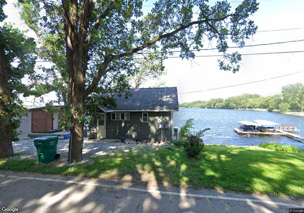
1779 Park Cir Clarion, IA 50525
Estimated Value: $224,185 - $335,000
1
Bed
1
Bath
352
Sq Ft
$757/Sq Ft
Est. Value
About This Home
This home is located at 1779 Park Cir, Clarion, IA 50525 and is currently estimated at $266,296, approximately $756 per square foot. 1779 Park Cir is a home located in Wright County with nearby schools including Clarion-Goldfield-Dows Elementary School, Clarion-Goldfield-Dows Middle School, and Clarion-Goldfield-Dows High School.
Ownership History
Date
Name
Owned For
Owner Type
Purchase Details
Closed on
Oct 25, 2017
Sold by
Krog Douglas A and Krog Karla J
Bought by
Plagge Landon and Plagge Anne
Current Estimated Value
Home Financials for this Owner
Home Financials are based on the most recent Mortgage that was taken out on this home.
Original Mortgage
$160,000
Outstanding Balance
$86,975
Interest Rate
3.83%
Mortgage Type
New Conventional
Estimated Equity
$179,321
Create a Home Valuation Report for This Property
The Home Valuation Report is an in-depth analysis detailing your home's value as well as a comparison with similar homes in the area
Home Values in the Area
Average Home Value in this Area
Purchase History
| Date | Buyer | Sale Price | Title Company |
|---|---|---|---|
| Plagge Landon | $202,500 | None Available |
Source: Public Records
Mortgage History
| Date | Status | Borrower | Loan Amount |
|---|---|---|---|
| Open | Plagge Landon | $160,000 |
Source: Public Records
Tax History Compared to Growth
Tax History
| Year | Tax Paid | Tax Assessment Tax Assessment Total Assessment is a certain percentage of the fair market value that is determined by local assessors to be the total taxable value of land and additions on the property. | Land | Improvement |
|---|---|---|---|---|
| 2025 | $1,940 | $149,900 | $83,200 | $66,700 |
| 2024 | $1,940 | $149,300 | $83,200 | $66,100 |
| 2023 | $1,939 | $149,300 | $83,200 | $66,100 |
| 2022 | $1,896 | $128,300 | $83,200 | $45,100 |
| 2021 | $1,896 | $128,400 | $83,200 | $45,200 |
| 2020 | $1,894 | $128,400 | $83,200 | $45,200 |
| 2019 | $1,937 | $131,100 | $0 | $0 |
| 2018 | $1,976 | $131,100 | $0 | $0 |
| 2017 | $1,932 | $131,100 | $0 | $0 |
| 2016 | $1,866 | $131,100 | $0 | $0 |
| 2015 | $1,838 | $131,100 | $0 | $0 |
| 2014 | $1,838 | $90,700 | $0 | $0 |
Source: Public Records
Map
Nearby Homes
- 1831 Page Ave
- 1881 Cornelia Dr
- 1884 Obrien Ave
- 2405 186th St Unit 2
- 2405 186th St Unit 1
- 620 Maple Ln
- 310 White Fox Dr
- 306 White Fox Dr
- 508 Maple Ln
- 519 6th St NE
- 1003 2nd Ave NE
- 903 2nd Ave NE
- 220 5th Ave NE
- 421 2nd Ave NE
- 617 1st Ave NE
- 603 1st Ave NE
- 909 1st Ave SE
- 212 3rd Ave NE
- 213 8th St SE
- 314 1st St NW