
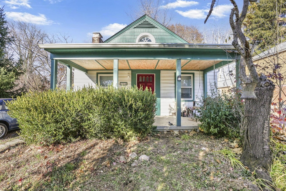
178 Hiawatha Ave Westerville, OH 43081
Estimated payment $1,396/month
2
Beds
1
Bath
932
Sq Ft
$268
Price per Sq Ft
Highlights
- Midcentury Modern Architecture
- Deck
- No HOA
- Whittier Elementary School Rated A-
- Sun or Florida Room
- Screened Porch
About This Home
Prime Uptown Westerville Investment Opportunity, sitting on two parcels!
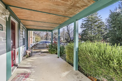
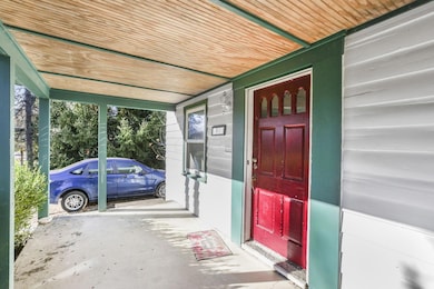
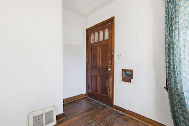
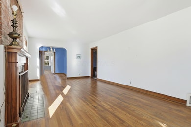
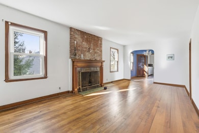
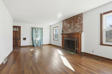
Located just steps from everything that makes Uptown Westerville iconic, this 2-bedroom, 1-bath ranch is the perfect canvas for your next project. Investors, flippers, or anyone craving location over lipstick, this one's calling your name. You're minutes from Otterbein University and a quick stroll to Uptown's boutiques, coffee shops, restaurants, and year-round events: 4th Fridays, the Independence Day Parade, Pumpkin Glow, and the beloved Tree Lighting & Parade of Lights. Buy now and you can close in time to enjoy the season's biggest celebrations right from your neighborhood. The bones, the lot, and the location make this home an unbelievable opportunity. Downstairs, you'll find a basement with a professionally installed egress window, as the space was previously used as a third bedroom. A perfect opportunity to finish the basement and instantly add functional square footage, whether you want to create a true third bedroom, rec room or office. Opportunities like this don't come up often in this pocket of Westerville, don't miss it.
Home Details
Home Type
- Single Family
Est. Annual Taxes
- $900
Year Built
- Built in 1939
Parking
- No Garage
Home Design
- Midcentury Modern Architecture
- Block Foundation
- Wood Siding
Interior Spaces
- 932 Sq Ft Home
- 1-Story Property
- Insulated Windows
- Sun or Florida Room
- Screened Porch
- Basement Fills Entire Space Under The House
Bedrooms and Bathrooms
- 2 Main Level Bedrooms
- 1 Full Bathroom
Utilities
- Forced Air Heating and Cooling System
- Heating System Uses Gas
Additional Features
- Deck
- 3,920 Sq Ft Lot
Community Details
- No Home Owners Association
Listing and Financial Details
- Assessor Parcel Number 080-000495
Map
Create a Home Valuation Report for This Property
The Home Valuation Report is an in-depth analysis detailing your home's value as well as a comparison with similar homes in the area
Home Values in the Area
Average Home Value in this Area
Tax History
| Year | Tax Paid | Tax Assessment Tax Assessment Total Assessment is a certain percentage of the fair market value that is determined by local assessors to be the total taxable value of land and additions on the property. | Land | Improvement |
|---|---|---|---|---|
| 2024 | $900 | $15,470 | $15,470 | -- |
| 2023 | $881 | $15,470 | $15,470 | $0 |
| 2022 | $716 | $9,590 | $9,590 | $0 |
| 2021 | $722 | $9,590 | $9,590 | $0 |
| 2020 | $720 | $9,590 | $9,590 | $0 |
| 2019 | $636 | $7,980 | $7,980 | $0 |
| 2018 | $590 | $7,980 | $7,980 | $0 |
| 2017 | $599 | $7,980 | $7,980 | $0 |
| 2016 | $573 | $6,650 | $6,650 | $0 |
| 2015 | $555 | $6,650 | $6,650 | $0 |
| 2014 | $556 | $6,650 | $6,650 | $0 |
| 2013 | $265 | $6,335 | $6,335 | $0 |
Source: Public Records
Property History
| Date | Event | Price | List to Sale | Price per Sq Ft |
|---|---|---|---|---|
| 11/23/2025 11/23/25 | Pending | -- | -- | -- |
| 11/20/2025 11/20/25 | For Sale | $250,000 | -- | $268 / Sq Ft |
Source: Columbus and Central Ohio Regional MLS
About the Listing Agent
I'm an expert real estate agent with KW Classic Properties Realty in Columbus, OH and the nearby area, providing home-buyers and sellers with professional, responsive and attentive real estate services. Want an agent who'll really listen to what you want in a home? Need an agent who knows how to effectively market your home so it sells? Give me a call! I'm eager to help and would love to talk to you.
Lauren's Other Listings
Source: Columbus and Central Ohio Regional MLS
MLS Number: 225043697
APN: 080-000495
Disclaimer: Certain information contained herein is derived from information provided by parties other than Homes.com. All information provided is deemed reliable, but is not guaranteed to be accurate and should be independently verified.
![]() IDX information is provided exclusively for personal, non-commercial use, and may not be used for any purpose other than to identify prospective properties consumers may be interested in purchasing.
IDX information is provided exclusively for personal, non-commercial use, and may not be used for any purpose other than to identify prospective properties consumers may be interested in purchasing.
Information is deemed reliable but not guaranteed.
Nearby Homes
- 35 Hiawatha Ave
- 502 Foxtrail Cir E Unit 502
- 206 Charring Cross Dr S Unit 2206
- 53 W College Ave
- 63 N West St
- 133 Illinois Ave
- 465 W Schrock Rd
- 92 N Vine St
- 125 Steffan Ct
- 559 Allview Ct
- 89 Lancelot Ln Unit 89
- 274 Storington Rd
- 25 King Arthur Blvd
- 92 Kennebec Place E
- 368 E College Ave
- 437 Potawatomi Dr
- 385 Hockberry Ave Unit Lot 1603
- 322 Pinnate Ln Unit Lot 1201
- 324 Pinnate Ln Unit Lot 1202
- 321 Pinnate Ln Unit Lot 1504