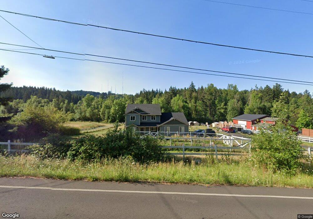
1780 Lorane Hwy Eugene, OR 97405
Estimated Value: $713,000 - $925,000
4
Beds
3
Baths
2,792
Sq Ft
$287/Sq Ft
Est. Value
About This Home
This home is located at 1780 Lorane Hwy, Eugene, OR 97405 and is currently estimated at $801,090, approximately $286 per square foot. 1780 Lorane Hwy is a home with nearby schools including Adams Elementary School, Arts And Technology Academy At Jefferson, and Churchill High School.
Ownership History
Date
Name
Owned For
Owner Type
Purchase Details
Closed on
Dec 30, 2020
Sold by
Forrest R Scott R and Forrest Cecelia L
Bought by
Rogers George C and Rogers Kathryn A
Current Estimated Value
Home Financials for this Owner
Home Financials are based on the most recent Mortgage that was taken out on this home.
Original Mortgage
$168,750
Outstanding Balance
$149,891
Interest Rate
2.7%
Mortgage Type
Commercial
Estimated Equity
$651,199
Purchase Details
Closed on
Oct 21, 2014
Sold by
Forrest Richard S and Forrest Cecelia L
Bought by
Forrest Joint Trust
Purchase Details
Closed on
Sep 19, 2008
Sold by
Curson Rick and Curson Stacey
Bought by
Forrest Richard Scott and Forrest Cecelia L
Create a Home Valuation Report for This Property
The Home Valuation Report is an in-depth analysis detailing your home's value as well as a comparison with similar homes in the area
Purchase History
| Date | Buyer | Sale Price | Title Company |
|---|---|---|---|
| Rogers George C | $225,000 | Fidelity National Title | |
| Forrest Joint Trust | -- | None Available | |
| Forrest Richard Scott | $175,350 | First American |
Source: Public Records
Mortgage History
| Date | Status | Borrower | Loan Amount |
|---|---|---|---|
| Open | Rogers George C | $168,750 |
Source: Public Records
Tax History
| Year | Tax Paid | Tax Assessment Tax Assessment Total Assessment is a certain percentage of the fair market value that is determined by local assessors to be the total taxable value of land and additions on the property. | Land | Improvement |
|---|---|---|---|---|
| 2025 | $4,201 | $307,658 | -- | -- |
| 2024 | $4,173 | $298,698 | -- | -- |
| 2023 | $4,173 | $289,999 | $0 | $0 |
| 2022 | $2,253 | $159,526 | $0 | $0 |
| 2021 | $745 | $55,559 | $0 | $0 |
| 2020 | $756 | $53,941 | $0 | $0 |
| 2019 | $728 | $52,370 | $0 | $0 |
| 2018 | $673 | $49,364 | $0 | $0 |
| 2017 | $648 | $49,364 | $0 | $0 |
| 2016 | $630 | $47,926 | $0 | $0 |
| 2015 | $615 | $46,530 | $0 | $0 |
| 2014 | $605 | $45,175 | $0 | $0 |
Source: Public Records
Map
Nearby Homes
- 2030 W 34th Ave
- 0 Mclean Blvd Unit 24671448
- 0 Mclean Blvd Unit 697374759
- 1783 Graham Dr
- 3023 Ashley Loop
- 0 W 40th Ave Unit 3 545854116
- 0 W 40th Ave Unit 3 639571582
- 3087 Whitbeck Blvd
- 3093 Soloman Loop
- 3160 Whitten Dr
- 2850 Garfield St
- 4040 Southpointe Dr
- 1 Storey Blvd
- 2 Storey Blvd
- 2673 Garfield St
- 806 Sundance St
- 3854 Monroe St
- 2225 W 28th Ave
- 2455 W 29th Ave
- 0 Hidden Meadows
- 1890 Lorane Hwy
- 1760 Lorane Hwy
- 1765 Lorane Hwy
- 1775 Lorane Hwy
- 1755 Lorane Hwy
- 1785 Lorane Hwy
- 1928 Lorane Hwy
- 1745 Lorane Hwy
- 1795 Lorane Hwy
- 1762 W 34th Place
- 1950 Lorane Hwy
- 1752 W 34th Place
- 1772 W 34th Place
- 1725 Lorane Hwy
- 1742 W 34th Place
- 1792 W 34th Place
- 3480 Chambers St
- 1703 Lorane Hwy
- 1728 W 34th Place
- 1702 Lorane Hwy
Your Personal Tour Guide
Ask me questions while you tour the home.