Estimated Value: $286,000 - $328,000
4
Beds
2
Baths
1,557
Sq Ft
$203/Sq Ft
Est. Value
About This Home
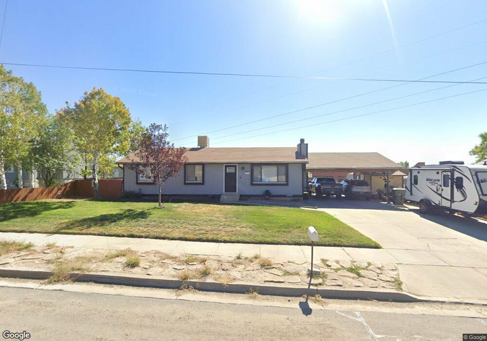
This home is located at 1782 E 800 N, Price, UT 84501 and is currently estimated at $315,351, approximately $202 per square foot. 1782 E 800 N is a home located in Carbon County with nearby schools including Castle Heights School, Mont Harmon Junior High School, and Carbon High School.
Ownership History
Date
Name
Owned For
Owner Type
Purchase Details
Closed on
Aug 10, 2023
Sold by
Elb Holdings Llc
Bought by
Marvidikis Nathan
Current Estimated Value
Home Financials for this Owner
Home Financials are based on the most recent Mortgage that was taken out on this home.
Original Mortgage
$16,584
Outstanding Balance
$16,182
Interest Rate
6.71%
Estimated Equity
$299,169
Purchase Details
Closed on
Oct 21, 2022
Sold by
Bailey Lana
Bought by
Elb Holdings Llc
Home Financials for this Owner
Home Financials are based on the most recent Mortgage that was taken out on this home.
Original Mortgage
$214,900
Interest Rate
5.63%
Mortgage Type
New Conventional
Create a Home Valuation Report for This Property
The Home Valuation Report is an in-depth analysis detailing your home's value as well as a comparison with similar homes in the area
Purchase History
| Date | Buyer | Sale Price | Title Company |
|---|---|---|---|
| Marvidikis Nathan | -- | Professional Title Services | |
| Elb Holdings Llc | -- | Inwest Title | |
| Bailey Lana | -- | Inwest Title |
Source: Public Records
Mortgage History
| Date | Status | Borrower | Loan Amount |
|---|---|---|---|
| Open | Marvidikis Nathan | $16,584 | |
| Open | Marvidikis Nathan | $276,400 | |
| Previous Owner | Bailey Lana | $214,900 |
Source: Public Records
Tax History
| Year | Tax Paid | Tax Assessment Tax Assessment Total Assessment is a certain percentage of the fair market value that is determined by local assessors to be the total taxable value of land and additions on the property. | Land | Improvement |
|---|---|---|---|---|
| 2025 | $1,933 | $159,067 | $13,634 | $145,433 |
| 2024 | $1,762 | $146,677 | $12,788 | $133,889 |
| 2023 | $1,647 | $146,227 | $12,014 | $134,213 |
| 2022 | $1,722 | $249,453 | $18,162 | $231,291 |
| 2021 | $1,479 | $182,864 | $15,262 | $167,602 |
| 2020 | $1,451 | $89,996 | $0 | $0 |
| 2019 | $1,290 | $83,910 | $0 | $0 |
| 2018 | $1,133 | $75,213 | $0 | $0 |
| 2017 | $1,119 | $75,213 | $0 | $0 |
| 2016 | $1,010 | $75,213 | $0 | $0 |
| 2015 | $1,010 | $75,213 | $0 | $0 |
| 2014 | $1,003 | $75,213 | $0 | $0 |
| 2013 | $1,065 | $79,101 | $0 | $0 |
Source: Public Records
Map
Nearby Homes
- 831 N 1820 E Unit 66
- 1830 E 840 N Unit 80
- 1841 E 8th N Unit 78
- 1840 E 840 N Unit 81
- 1829 E 840 N Unit 87
- 1855 E 8th N Unit 77
- 1858 E 840 N Unit 82
- 1843 E 840 N Unit 86
- 1857 E 840 N Unit 85
- 1871 E 840 N Unit 84
- 838 N 1880 E Unit 73
- 854 N 1880 E Unit 72
- 868 N 1880 E Unit 71
- 835 Essex Cir
- 1875 E 880 N
- 1535 Sagewood Rd
- 546 Windsor Rd
- 688 Birch Cir
- 1348 Sagewood Rd
- 883 N 1000 E
- 1780 E 800 N
- 1796 E 800 N
- 1778 E 800 N
- 1785 E 800 N
- 1785 E 800 N
- 1785 E 800 N
- 1816 E 800 N
- 1777 E 800 N
- 1744 E 800 N
- 835 Castle Heights Dr
- 816 Castle Heights Dr
- 828 Blarney Cir
- 832 Castle Heights Dr
- 825 Blarney Cir
- 1716 E 800 N
- 845 Castle Heights Dr
- 838 Blarney Cir
- 844 Castle Heights Dr
- 829 N 1820 E
- 835 Blarney Cir
Your Personal Tour Guide
Ask me questions while you tour the home.