

1785 Hodgson Rd Whitefish, MT 59937
Estimated payment $4,976/month
Highlights
- Horses Allowed On Property
- 1.28 Acre Lot
- 2 Fireplaces
- Whitefish Middle School Rated A
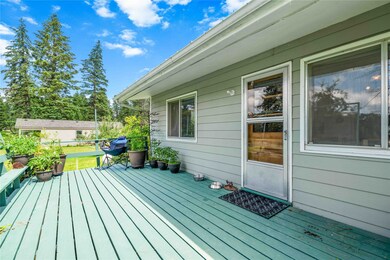
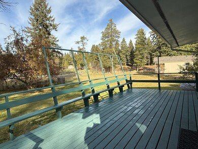
- Deck
- No HOA
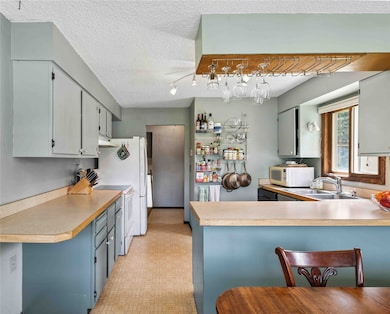
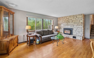
About This Home
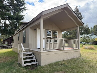
Two Homes on a 1.28-Acre Property. Enjoy the perfect blend of country living and city convenience. This versatile property features two homes, a fully fenced yard for horses and dogs, a hay barn, fruit-bearing apple trees, and a 40' x 35' x 8' garden ready for your green thumb. Located just minutes from Whitefish, the property also offers close access to 480 acres of nearby state land—perfect for running, walking, biking, or exercising pets. The offset two-story main home offers original hardwood floors, a travertine rock fireplace with propane stove, and solid “loved-in” bones, ideal for updates or renovation. Recent upgrades include a new roof, upgraded septTHic system, and freshly painted exterior and deck, providing peace of mind. The 756 sq ft guest house with an 8' covered front deck adds flexibility for a home office, rental potential, or extra living space. Additional features include a fire pit and covered carport. With two homes on one property, this is a unique opportunity for a multi-generational retreat, rental income, or a homestead, all while staying close to city amenities and outdoor recreation.
Listing Agent
Century 21 Deaton and Company Real Estate License #RRE-BRO-LIC-31639 Listed on: 07/28/2025

Home Details
Home Type
- Single Family
Est. Annual Taxes
- $2,906
Year Built
- Built in 1973
Lot Details
- 1.28 Acre Lot
- Split Rail Fence
- Wire Fence
- Landscaped
- Level Lot
- Back and Front Yard
Parking
- 2 Carport Spaces
Home Design
- Poured Concrete
Interior Spaces
- 3,172 Sq Ft Home
- Property has 2 Levels
- Living Quarters
- 2 Fireplaces
Kitchen
- Oven or Range
- Dishwasher
Bedrooms and Bathrooms
- 6 Bedrooms
Finished Basement
- Basement Fills Entire Space Under The House
- Natural lighting in basement
Outdoor Features
- Deck
- Shed
- Porch
Horse Facilities and Amenities
- Horses Allowed On Property
Utilities
- Radiant Ceiling
- Heating System Uses Propane
- Baseboard Heating
- Propane
- Septic Tank
- Private Sewer
- High Speed Internet
Community Details
- No Home Owners Association
Listing and Financial Details
- Exclusions: window a/c, bar fridge, W/D
- Assessor Parcel Number 07418529223010000
Map
Home Values in the Area
Average Home Value in this Area
Tax History
| Year | Tax Paid | Tax Assessment Tax Assessment Total Assessment is a certain percentage of the fair market value that is determined by local assessors to be the total taxable value of land and additions on the property. | Land | Improvement |
|---|---|---|---|---|
| 2025 | $2,167 | $698,000 | $0 | $0 |
| 2024 | $2,509 | $547,300 | $0 | $0 |
| 2023 | $2,720 | $547,300 | $0 | $0 |
| 2022 | $2,013 | $326,500 | $0 | $0 |
| 2021 | $2,186 | $326,500 | $0 | $0 |
| 2020 | $2,399 | $317,000 | $0 | $0 |
| 2019 | $2,556 | $317,000 | $0 | $0 |
| 2018 | $2,335 | $280,600 | $0 | $0 |
| 2017 | $2,192 | $280,600 | $0 | $0 |
| 2016 | $2,018 | $251,400 | $0 | $0 |
| 2015 | $1,993 | $251,400 | $0 | $0 |
| 2014 | $1,944 | $150,520 | $0 | $0 |
Property History
| Date | Event | Price | List to Sale | Price per Sq Ft |
|---|---|---|---|---|
| 10/17/2025 10/17/25 | For Sale | $899,000 | 0.0% | $283 / Sq Ft |
| 10/15/2025 10/15/25 | Off Market | -- | -- | -- |
| 10/06/2025 10/06/25 | Price Changed | $899,000 | -4.9% | $283 / Sq Ft |
| 09/22/2025 09/22/25 | Price Changed | $945,000 | -5.0% | $298 / Sq Ft |
| 07/28/2025 07/28/25 | For Sale | $995,000 | -- | $314 / Sq Ft |
Purchase History
| Date | Type | Sale Price | Title Company |
|---|---|---|---|
| Warranty Deed | -- | Alliance Title |
Mortgage History
| Date | Status | Loan Amount | Loan Type |
|---|---|---|---|
| Open | $275,975 | New Conventional |
Source: Montana Regional MLS
MLS Number: 30054700
APN: 07-4185-29-2-23-01-0000
Disclaimer: Certain information contained herein is derived from information provided by parties other than Homes.com. All information provided is deemed reliable, but is not guaranteed to be accurate and should be independently verified.
![]() IDX information is provided exclusively for personal, non-commercial use, and may not be used for any purpose other than to identify prospective properties consumers may be interested in purchasing. Information is deemed reliable but not guaranteed.
IDX information is provided exclusively for personal, non-commercial use, and may not be used for any purpose other than to identify prospective properties consumers may be interested in purchasing. Information is deemed reliable but not guaranteed.
- 115 Autumn Ct
- 128 Mallard Loop
- 257 Fawn Trail
- 227 Goat Trail
- 181 Mallard Loop
- 429 Bear Trail
- 321 Cougar Trail
- 109 Lidstrom Rd
- 105 Antelope Trail
- 56 Wagon Wheel Rd
- 4830 U S 93
- 125 Wagon Wheel Rd
- 5092 U S 93
- 35 Stagecoach Dr
- 306 Plantation Dr
- 4870 US Highway 93 S Unit 38
- 182 Rosewood Ln Unit Lot 15
- 142 Rosewood Ln Unit Lot 18
- 185 Rosewood Ln Unit Lot 14
- 161 Rosewood Unit Lot 10
- 254 Goat Trail
- 328 Cougar Trail
- 6300 Locarno Dr Unit K
- 6005 St Moritz Dr Unit B
- 6002 St Moritz Dr Unit G
- 6008 St Moritz Dr Unit L
- 60 Elderberry Loop
- 275 C Blackberry Loop
- 269 Blackberry Loop
- 57 Hickory Loop
- 15 Sagebrush Ct Unit B
- 2119 Wintercrest Dr
- 875 Birch Grove Rd
- 150 Daylilly Dr
- 800 Harvest Vw Ln
- 3431 Goldenrod Ln
- 1047 Columbia Ave
- 1010 Baker Ave Unit 302
- 901 Kalispell Ave
- 1005 Creekview Dr