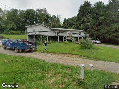
17899 State Route 374 Rockbridge, OH 43149
Estimated Value: $254,655 - $972,000
--
Bed
1
Bath
2,592
Sq Ft
$186/Sq Ft
Est. Value
About This Home
This home is located at 17899 State Route 374, Rockbridge, OH 43149 and is currently estimated at $482,914, approximately $186 per square foot. 17899 State Route 374 is a home located in Hocking County with nearby schools including Hocking Hills Elementary School.
Create a Home Valuation Report for This Property
The Home Valuation Report is an in-depth analysis detailing your home's value as well as a comparison with similar homes in the area
Home Values in the Area
Average Home Value in this Area
Mortgage History
| Date | Status | Borrower | Loan Amount |
|---|---|---|---|
| Closed | Fortner Curtis A | $104,500 |
Source: Public Records
Tax History Compared to Growth
Tax History
| Year | Tax Paid | Tax Assessment Tax Assessment Total Assessment is a certain percentage of the fair market value that is determined by local assessors to be the total taxable value of land and additions on the property. | Land | Improvement |
|---|---|---|---|---|
| 2024 | $1,558 | $41,360 | $13,740 | $27,620 |
| 2023 | $1,558 | $41,360 | $13,740 | $27,620 |
| 2022 | $1,561 | $41,360 | $13,740 | $27,620 |
| 2021 | $1,348 | $33,450 | $9,680 | $23,770 |
| 2020 | $1,348 | $33,450 | $9,680 | $23,770 |
| 2019 | $1,349 | $33,450 | $9,680 | $23,770 |
| 2018 | $1,254 | $31,750 | $7,980 | $23,770 |
| 2017 | $1,231 | $31,750 | $7,980 | $23,770 |
| 2016 | $1,222 | $31,750 | $7,980 | $23,770 |
| 2015 | $1,788 | $44,870 | $8,490 | $36,380 |
| 2014 | $1,788 | $44,870 | $8,490 | $36,380 |
| 2013 | $1,796 | $44,870 | $8,490 | $36,380 |
Source: Public Records
Map
Nearby Homes
- 17441 Keister Rd
- 16332 Kreashbaum Rd
- 22037 Ohio 180
- 0 Culp Rd Unit Lot D 225005132
- 15138 Ohio 678
- 14635 Little Cola Rd
- 19990 Sowers Rd
- 15971 Rocky Fork Rd
- 14650 State Route 678
- 21626 Chilcote Rd
- 13427 Ohio 374
- 23402 Bigham Rd
- 0 Unger Rd Unit Lot E 225013045
- 0 Unger Rd Unit Lot C 225007804
- 0 Unger Rd Unit Lot A 225006816
- 14485 Jack Run Rd
- 0 Blackjack Rd
- 19402 Kalklosch Rd
- 15586 Stump Run
- 24235 State Route 56
- 17899 State Route 374
- 17835 State Route 374
- 17864 State Route 374
- 18013 State Route 374
- 17727 State Route 374
- 18035 State Route 374
- 18038 State Route 374
- 18127 State Route 374
- 18221 State Route 374
- 17541 State Route 374
- 17515 State Route 374
- 18261 State Route 374
- 17630 State Route 374
- 17402 State Route 374
- 17634 State Route 374
- 17419 State Route 374
- 18331 State Route 374
- 18417 State Route 374
- 17268 State Route 374
- 17638 State Route 374