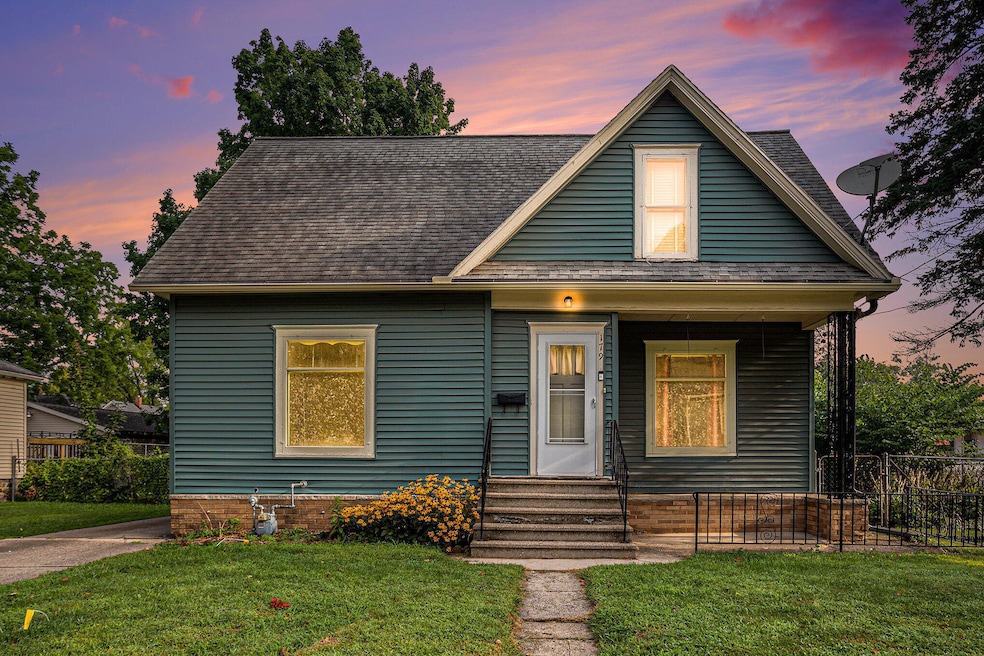


179 Bryant St Battle Creek, MI 49017
Northeast Battle Creek NeighborhoodEstimated payment $756/month
Highlights
- Deck
- No HOA
- Dehumidifier
- Traditional Architecture
- 1 Car Detached Garage
- Living Room
About This Home
* Back on the market at no fault of the sellers* Welcome to this adorable home that perfectly blends character and comfort! Featuring 3 bedrooms and 1.5 baths, this home offers a warm and inviting atmosphere from the moment you step inside. The spacious living room is filled with natural light, while the kitchen provides plenty of cabinet space and room to cook your favorite meals. Upstairs, you'll find 2 bedrooms and a full bath. The primary is a generous size with a walk in closet. Enjoy morning coffee on the front porch or entertain in the backyard. A detached garage adds convenience and extra storage. With its great curb appeal and functional layout, this home is ready for its next chapter! Come see it today!

Home Details
Home Type
- Single Family
Est. Annual Taxes
- $1,477
Year Built
- Built in 1907
Lot Details
- 7,623 Sq Ft Lot
- Lot Dimensions are 57.70 x 132
- Level Lot
- Garden
- Back Yard Fenced
Parking
- 1 Car Detached Garage
Home Design
- Traditional Architecture
- Composition Roof
- Vinyl Siding
Interior Spaces
- 1,101 Sq Ft Home
- 2-Story Property
- Ceiling Fan
- Living Room
Kitchen
- Oven
- Range
Flooring
- Carpet
- Linoleum
- Laminate
Bedrooms and Bathrooms
- 3 Bedrooms | 1 Main Level Bedroom
Laundry
- Dryer
- Washer
Basement
- Basement Fills Entire Space Under The House
- Laundry in Basement
Outdoor Features
- Deck
Utilities
- Dehumidifier
- Window Unit Cooling System
- Forced Air Heating System
- Heating System Uses Natural Gas
- Window Unit Heating System
- Private Water Source
- High Speed Internet
- Cable TV Available
Community Details
- No Home Owners Association
Map
Home Values in the Area
Average Home Value in this Area
Tax History
| Year | Tax Paid | Tax Assessment Tax Assessment Total Assessment is a certain percentage of the fair market value that is determined by local assessors to be the total taxable value of land and additions on the property. | Land | Improvement |
|---|---|---|---|---|
| 2025 | -- | $43,100 | $0 | $0 |
| 2024 | $1,071 | $38,958 | $0 | $0 |
| 2023 | $1,224 | $33,213 | $0 | $0 |
| 2022 | $967 | $29,462 | $0 | $0 |
| 2021 | $1,155 | $25,918 | $0 | $0 |
| 2020 | $996 | $25,468 | $0 | $0 |
| 2019 | $992 | $23,923 | $0 | $0 |
| 2018 | $992 | $26,648 | $1,010 | $25,638 |
| 2017 | $961 | $27,457 | $0 | $0 |
| 2016 | $960 | $23,603 | $0 | $0 |
| 2015 | $940 | $22,275 | $2,784 | $19,491 |
| 2014 | $940 | $22,679 | $2,784 | $19,895 |
Property History
| Date | Event | Price | Change | Sq Ft Price |
|---|---|---|---|---|
| 09/18/2025 09/18/25 | Pending | -- | -- | -- |
| 09/14/2025 09/14/25 | For Sale | $119,900 | 0.0% | $109 / Sq Ft |
| 09/01/2025 09/01/25 | Pending | -- | -- | -- |
| 08/28/2025 08/28/25 | Price Changed | $119,900 | -4.1% | $109 / Sq Ft |
| 08/14/2025 08/14/25 | For Sale | $125,000 | -- | $114 / Sq Ft |
Purchase History
| Date | Type | Sale Price | Title Company |
|---|---|---|---|
| Warranty Deed | $45,000 | Transnation Title Agency |
Mortgage History
| Date | Status | Loan Amount | Loan Type |
|---|---|---|---|
| Open | $42,750 | New Conventional | |
| Previous Owner | $55,214 | New Conventional | |
| Previous Owner | $62,400 | Unknown | |
| Previous Owner | $58,500 | Fannie Mae Freddie Mac |
Source: Southwestern Michigan Association of REALTORS®
MLS Number: 25041210
APN: 5760-00-057-0
Disclaimer: Certain information contained herein is derived from information provided by parties other than Homes.com. All information provided is deemed reliable, but is not guaranteed to be accurate and should be independently verified.
![]() Information is deemed reliable but not guaranteed.
Information is deemed reliable but not guaranteed.
Copyright 2025 MichRIC, LLC. All rights reserved.