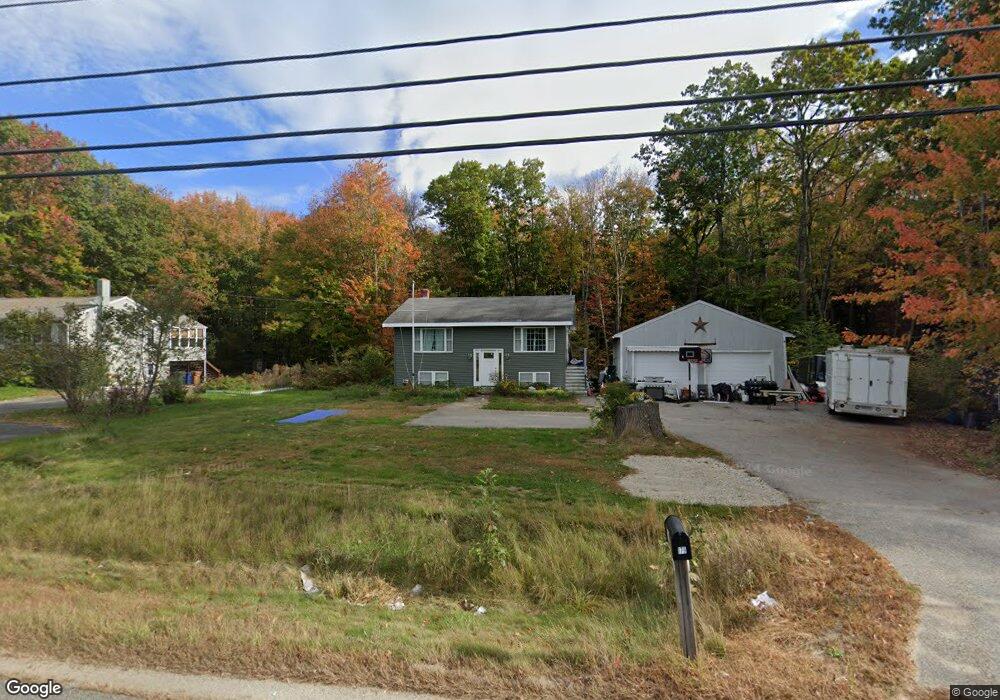
179 Buxton Rd Unit RD Saco, ME 04072
North Saco NeighborhoodEstimated Value: $410,000 - $463,000
3
Beds
1
Bath
1,416
Sq Ft
$306/Sq Ft
Est. Value
About This Home
This home is located at 179 Buxton Rd Unit RD, Saco, ME 04072 and is currently estimated at $433,469, approximately $306 per square foot. 179 Buxton Rd Unit RD is a home located in York County with nearby schools including C K Burns School, Saco Middle School, and Saint James School.
Ownership History
Date
Name
Owned For
Owner Type
Purchase Details
Closed on
May 2, 2012
Sold by
Stanwich Mtg Loan T
Bought by
Gower Lindsey
Current Estimated Value
Home Financials for this Owner
Home Financials are based on the most recent Mortgage that was taken out on this home.
Original Mortgage
$133,300
Outstanding Balance
$93,133
Interest Rate
4.08%
Mortgage Type
Unknown
Estimated Equity
$340,336
Purchase Details
Closed on
Feb 21, 2012
Sold by
Stanwich Mtg Loan T
Bought by
Stanwich Mtg Loan T and Wells Fargo Bank Na Tr
Purchase Details
Closed on
Aug 29, 2005
Sold by
Brouillard Kimberly A and Lemay Robert J
Bought by
Norris Jeremy and Thornton Allyson
Home Financials for this Owner
Home Financials are based on the most recent Mortgage that was taken out on this home.
Original Mortgage
$170,320
Interest Rate
6%
Mortgage Type
Adjustable Rate Mortgage/ARM
Create a Home Valuation Report for This Property
The Home Valuation Report is an in-depth analysis detailing your home's value as well as a comparison with similar homes in the area
Home Values in the Area
Average Home Value in this Area
Purchase History
| Date | Buyer | Sale Price | Title Company |
|---|---|---|---|
| Gower Lindsey | $135,000 | -- | |
| Stanwich Mtg Loan T | -- | -- | |
| Norris Jeremy | -- | -- |
Source: Public Records
Mortgage History
| Date | Status | Borrower | Loan Amount |
|---|---|---|---|
| Open | Gower Lindsey | $133,300 | |
| Previous Owner | Norris Jeremy | $170,320 | |
| Previous Owner | Norris Jeremy | $42,580 |
Source: Public Records
Tax History Compared to Growth
Tax History
| Year | Tax Paid | Tax Assessment Tax Assessment Total Assessment is a certain percentage of the fair market value that is determined by local assessors to be the total taxable value of land and additions on the property. | Land | Improvement |
|---|---|---|---|---|
| 2024 | $4,573 | $325,500 | $149,300 | $176,200 |
| 2023 | $4,801 | $325,500 | $149,300 | $176,200 |
| 2022 | $4,410 | $240,600 | $113,600 | $127,000 |
| 2021 | $4,261 | $225,700 | $102,300 | $123,400 |
| 2020 | $5,420 | $204,300 | $90,200 | $114,100 |
| 2019 | $3,959 | $204,300 | $90,200 | $114,100 |
| 2018 | $3,769 | $194,500 | $81,900 | $112,600 |
| 2017 | $3,610 | $186,300 | $74,900 | $111,400 |
| 2016 | $4,766 | $160,700 | $58,600 | $102,100 |
| 2015 | $3,068 | $159,600 | $58,600 | $101,000 |
| 2014 | $2,972 | $159,600 | $58,600 | $101,000 |
| 2013 | $2,965 | $159,600 | $58,600 | $101,000 |
Source: Public Records
Map
Nearby Homes
- Lot 2 TBD Bobby Ave
- 295 Buxton Rd
- 224 New County Rd
- 10 Jeffrey Ave
- 37 Douglas Ave
- 4 Spool St Unit 101
- 436 Flag Pond Rd
- 48 Hillview Ave
- lot 2 June Dr
- lot 3 June Dr
- 43 New County Rd
- 9 Jada Dr
- 8 Nottingham Dr
- 48 Garfield St Unit 9
- 4 Smutty Ln
- 5 Marguerite Rd
- TBD Cribble Cove Rd
- 12 Shadagee Rd
- 7 Hubbard St
- 11 Brentwood Cir